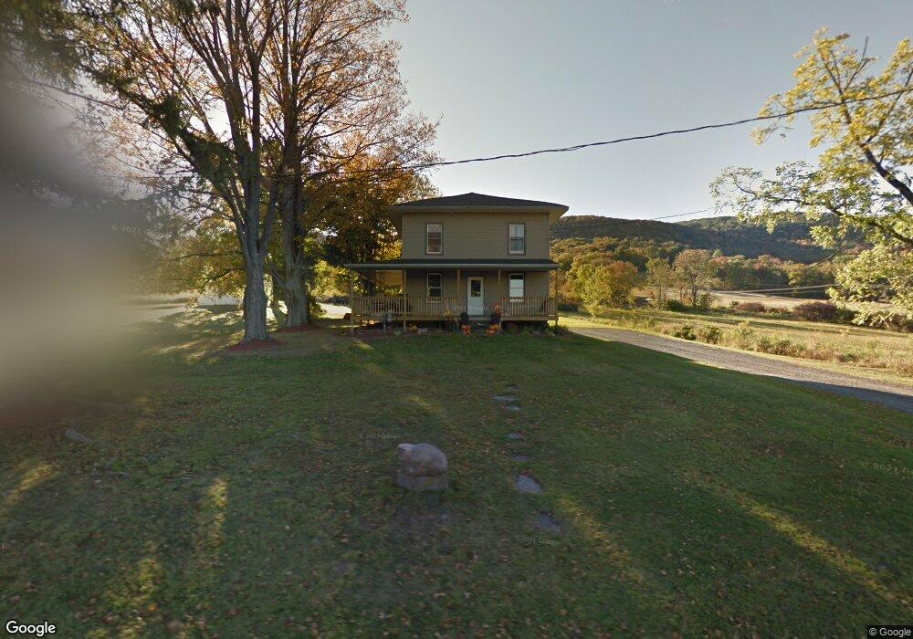
417 Newell Rd Canton, PA 17724
Estimated Value: $151,386 - $256,000
3
Beds
4
Baths
--
Sq Ft
1.5
Acres
About This Home
This home is located at 417 Newell Rd, Canton, PA 17724 and is currently estimated at $208,097. 417 Newell Rd is a home located in Bradford County with nearby schools including Canton Area Elementary School and Canton Junior/Senior High School.
Ownership History
Date
Name
Owned For
Owner Type
Purchase Details
Closed on
Feb 16, 2017
Sold by
Rockwell Matthew J and Rockwell Amanda J
Bought by
Rockwell Matthew J and Rockwell Amanda J
Current Estimated Value
Home Financials for this Owner
Home Financials are based on the most recent Mortgage that was taken out on this home.
Original Mortgage
$112,500
Outstanding Balance
$56,617
Interest Rate
4.09%
Mortgage Type
New Conventional
Estimated Equity
$151,480
Purchase Details
Closed on
Nov 10, 2007
Sold by
Sennert Judy A
Bought by
Rockwell Matthew J
Home Financials for this Owner
Home Financials are based on the most recent Mortgage that was taken out on this home.
Original Mortgage
$47,000
Interest Rate
6.48%
Mortgage Type
New Conventional
Create a Home Valuation Report for This Property
The Home Valuation Report is an in-depth analysis detailing your home's value as well as a comparison with similar homes in the area
Home Values in the Area
Average Home Value in this Area
Purchase History
| Date | Buyer | Sale Price | Title Company |
|---|---|---|---|
| Rockwell Matthew J | -- | None Available | |
| Rockwell Matthew J | $50,000 | None Available |
Source: Public Records
Mortgage History
| Date | Status | Borrower | Loan Amount |
|---|---|---|---|
| Open | Rockwell Matthew J | $112,500 | |
| Closed | Rockwell Matthew J | $47,000 |
Source: Public Records
Tax History Compared to Growth
Tax History
| Year | Tax Paid | Tax Assessment Tax Assessment Total Assessment is a certain percentage of the fair market value that is determined by local assessors to be the total taxable value of land and additions on the property. | Land | Improvement |
|---|---|---|---|---|
| 2025 | $1,809 | $32,600 | $0 | $0 |
| 2024 | $1,738 | $32,600 | $0 | $0 |
| 2023 | $1,738 | $32,600 | $0 | $0 |
| 2022 | $1,719 | $32,600 | $0 | $0 |
| 2021 | $1,719 | $32,600 | $0 | $0 |
| 2020 | $1,700 | $32,600 | $0 | $0 |
| 2019 | $1,698 | $32,600 | $0 | $0 |
| 2018 | $1,625 | $32,600 | $0 | $0 |
| 2017 | $1,603 | $32,600 | $0 | $0 |
| 2016 | -- | $32,600 | $0 | $0 |
| 2015 | -- | $32,600 | $0 | $0 |
| 2014 | $679 | $32,600 | $0 | $0 |
Source: Public Records
Map
Nearby Homes
- Upper Mountain Rd Lot Unit WP001
- 0 Upper Mountain Rd
- 19 Lovell Ln
- 386 Troy St
- 290 Troy St
- 85 N Minnequa Ave
- 127 Troy St
- 94 N Center St
- 55 Clinton St
- 63 Brann St
- 14751 Route 14
- 108 S Washington St
- 49-51 T-329
- 374 S Minnequa Ave
- 118 E South Ave
- 417 Furman Rd
- 1616 W Union Rd
- 1616 W Union St
- 1751 Douglas Rd
- 2004 Fall Brook Rd