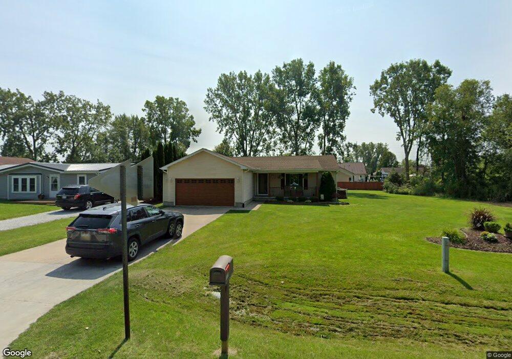
4171 Neuman Rd Saint Clair, MI 48079
Estimated Value: $383,000 - $456,000
3
Beds
3
Baths
1,754
Sq Ft
$243/Sq Ft
Est. Value
About This Home
This home is located at 4171 Neuman Rd, Saint Clair, MI 48079 and is currently estimated at $425,503, approximately $242 per square foot. 4171 Neuman Rd is a home located in St. Clair County with nearby schools including Gearing Elementary School, St. Clair Middle School, and St. Clair High School.
Ownership History
Date
Name
Owned For
Owner Type
Purchase Details
Closed on
Apr 28, 2025
Sold by
Malec Delmar M and Malec Rosemary M
Bought by
Malec Delmar M and Malec Rosemary M
Current Estimated Value
Purchase Details
Closed on
Aug 6, 2013
Sold by
Lc3 Development Llc
Bought by
Malec Delmar and Malec Rosemary
Purchase Details
Closed on
Sep 21, 2011
Sold by
Vansingel David and Vansingel Kelly
Bought by
Lc3 Development Llc
Create a Home Valuation Report for This Property
The Home Valuation Report is an in-depth analysis detailing your home's value as well as a comparison with similar homes in the area
Home Values in the Area
Average Home Value in this Area
Purchase History
We collect this data history from publicly available records. To have your information removed, we recommend requesting removal directly through your county’s website.
| Date | Buyer | Sale Price | Title Company |
|---|---|---|---|
| Malec Delmar M | -- | None Listed On Document | |
| Malec Delmar M | -- | None Listed On Document | |
| Malec Delmar | $184,000 | Attorneys Title Agency Llc | |
| Lc3 Development Llc | -- | None Available |
Source: Public Records
Tax History
| Year | Tax Paid | Tax Assessment Tax Assessment Total Assessment is a certain percentage of the fair market value that is determined by local assessors to be the total taxable value of land and additions on the property. | Land | Improvement |
|---|---|---|---|---|
| 2025 | $2,496 | $233,100 | $0 | $0 |
| 2024 | $2,421 | $202,700 | $0 | $0 |
| 2023 | $2,225 | $182,700 | $0 | $0 |
| 2022 | $2,311 | $152,900 | $0 | $0 |
| 2020 | $867 | $164,900 | $164,900 | $0 |
| 2019 | $857 | $125,500 | $0 | $0 |
| 2018 | $2,959 | $125,500 | $0 | $0 |
| 2017 | $2,888 | $124,000 | $0 | $0 |
| 2016 | $2,069 | $124,000 | $0 | $0 |
| 2015 | -- | $119,500 | $119,500 | $0 |
| 2014 | -- | $112,100 | $112,100 | $0 |
| 2013 | -- | $91,000 | $0 | $0 |
Source: Public Records
Map
Nearby Homes
- 50 Golfside Dr
- 1715 River #76 Rd Unit 76
- 2118 N River Rd
- 1715 River #44 Rd Unit 44
- 1715 River Rd 39 Rd Unit 39
- 1715 River Rd Unit 41
- 1715 River Rd Unit 22
- 308 Fairway Ct
- 1931 Pug Rd
- 1 Golfside Dr Unit 4
- 3072 Regatta Ln
- 3143 Regatta Ln
- 3071 Regatta Ln
- 3059 Regatta Ln
- 3108 Regatta Ln
- 4296 Scott B Dr
- 2376 Joseph Tamron Dr W
- 2516 River Rd
- 50 Mack Ave Unit 71
- 1856 S Allen Rd
- 4171 Neuman Rd
- 4165 Neuman Rd
- 4161 Neuman Rd
- 4164 Violet Ave
- 4174 Violet Ave
- 4155 Neuman Rd
- 4185 Neuman Rd
- 4160 Violet Ave
- 4180 Violet Ave
- V/L Neuman
- 4154 Violet Ave
- 4170 Neuman Rd
- 4184 Violet Ave
- 4151 Neuman Rd
- 4191 Neuman Rd
- 4150 Violet Ave
- 4190 Violet Ave
- 4192 Neuman Rd
- 4141 Neuman Rd
- 4201 Neuman Rd
Your Personal Tour Guide
Ask me questions while you tour the home.