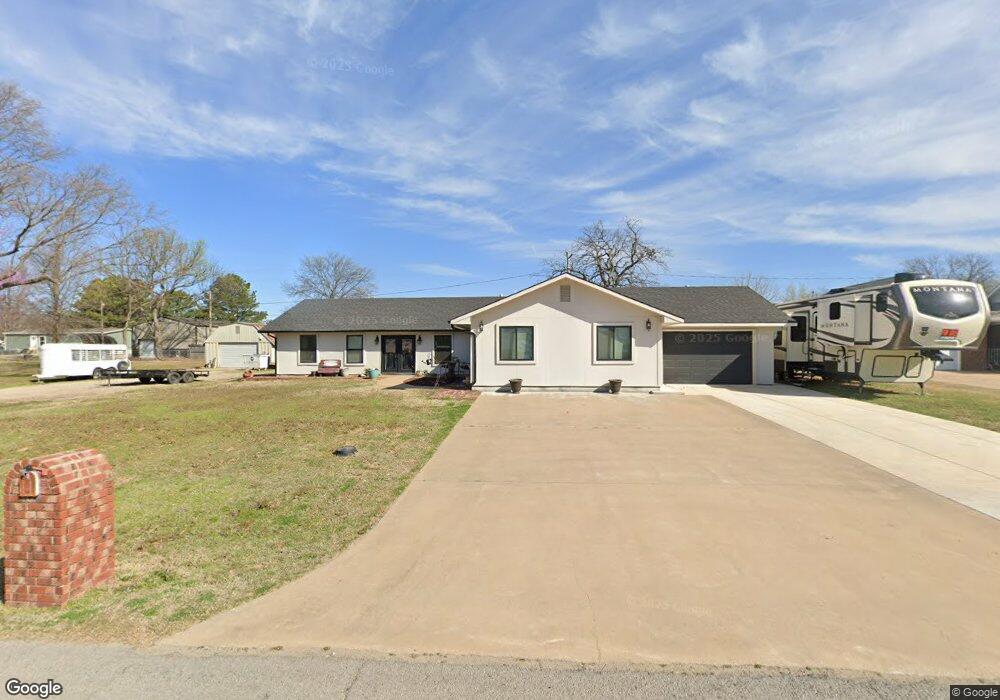
417553 Bridgeport Rd Eufaula, OK 74432
Estimated Value: $220,080 - $350,000
3
Beds
2
Baths
1,366
Sq Ft
$216/Sq Ft
Est. Value
About This Home
This home is located at 417553 Bridgeport Rd, Eufaula, OK 74432 and is currently estimated at $295,520, approximately $216 per square foot. 417553 Bridgeport Rd is a home located in McIntosh County with nearby schools including Eufaula Elementary School, Eufaula Middle School, and Eufaula High School.
Ownership History
Date
Name
Owned For
Owner Type
Purchase Details
Closed on
Jan 25, 2022
Sold by
Thompson and Sheryl
Bought by
Bichsel Ronnie Lynn and Bichsel Beverly Jean
Current Estimated Value
Purchase Details
Closed on
Dec 14, 2007
Sold by
Mann Jamison B
Bought by
Thompson Terrence and Thompson Sheryl
Home Financials for this Owner
Home Financials are based on the most recent Mortgage that was taken out on this home.
Original Mortgage
$50,000
Interest Rate
6.3%
Mortgage Type
New Conventional
Purchase Details
Closed on
May 29, 1999
Sold by
Meyer
Bought by
Nixon and Garner
Create a Home Valuation Report for This Property
The Home Valuation Report is an in-depth analysis detailing your home's value as well as a comparison with similar homes in the area
Home Values in the Area
Average Home Value in this Area
Purchase History
| Date | Buyer | Sale Price | Title Company |
|---|---|---|---|
| Bichsel Ronnie Lynn | $115,000 | None Listed On Document | |
| Thompson Terrence | $122,500 | None Available | |
| Nixon | $85,000 | -- |
Source: Public Records
Mortgage History
| Date | Status | Borrower | Loan Amount |
|---|---|---|---|
| Previous Owner | Thompson Terrence | $50,000 |
Source: Public Records
Tax History Compared to Growth
Tax History
| Year | Tax Paid | Tax Assessment Tax Assessment Total Assessment is a certain percentage of the fair market value that is determined by local assessors to be the total taxable value of land and additions on the property. | Land | Improvement |
|---|---|---|---|---|
| 2025 | $2,322 | $27,520 | $1,954 | $25,566 |
| 2024 | $2,247 | $27,521 | $1,898 | $25,623 |
| 2023 | $2,247 | $25,941 | $1,898 | $24,043 |
| 2022 | $1,058 | $13,754 | $1,898 | $11,856 |
| 2021 | $1,154 | $13,754 | $1,898 | $11,856 |
| 2020 | $1,155 | $13,754 | $1,898 | $11,856 |
| 2019 | $1,165 | $13,754 | $1,898 | $11,856 |
| 2018 | $1,093 | $13,754 | $1,898 | $11,856 |
| 2017 | $1,042 | $12,504 | $1,898 | $10,606 |
| 2016 | $1,042 | $12,450 | $1,898 | $10,552 |
| 2015 | $979 | $11,857 | $1,898 | $9,959 |
| 2014 | $990 | $12,062 | $1,898 | $10,164 |
Source: Public Records
Map
Nearby Homes
- 114516 Portside Dr
- 34 E 1145 Rd
- 417601 E 1145 Rd
- 417717 E 1145 Rd
- 417394 E 1145
- 417308 Bridgeport Rd
- 417292 E 1145 Rd
- 114583 S 4172 Cir Unit 119
- 419036 E 1144 Rd
- 419124 E 1144 Rd
- 417082 E 1143
- 114245 S 4172 Cir
- 1 E Lakeview Dr
- 114399 Oak Rd
- 114276 S 4170 Rd
- 20 Lake View Rd
- 00 Whippoorwill St
- 04 Meadowood
- 00 Flamingo St
- 0 4189 Rd Unit 2532341
- Box 16 Rr 6
- Rt 6, Box 353 Rr 6
- 114182 S 4179 Rd
- 417529 Bridgeport Rd
- 417558 Bridgeport Rd
- 417532 E 1145 Rd
- 417493 Bridgeport Rd
- 114591 Beachview Cir
- 114546 Beachview Cir
- 114579 Beachview Cir
- 0 1145 Rd Unit 2314480
- 0 1145 Rd Unit 2111856
- 0 1145 Rd Unit 2212528
- 114569 Portside Dr
- 417478 E 1145 Rd
- 1301 SW 122nd St
- 384 Rr 6
- 114563 Driftwood Ln
- 114585 Driftwood Ln
- 0 Driftwood Ln