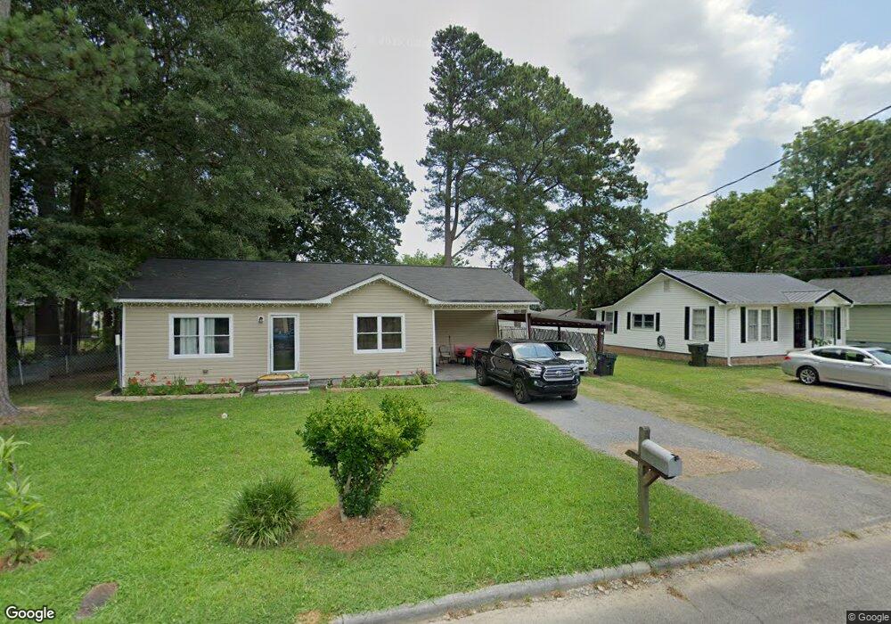
418 Anderson Ave Dalton, GA 30721
Estimated Value: $171,467 - $215,000
3
Beds
1
Bath
1,044
Sq Ft
$189/Sq Ft
Est. Value
About This Home
This home is located at 418 Anderson Ave, Dalton, GA 30721 and is currently estimated at $197,617, approximately $189 per square foot. 418 Anderson Ave is a home located in Whitfield County with nearby schools including Roan Elementary School, Dalton Middle School, and Dalton High School.
Ownership History
Date
Name
Owned For
Owner Type
Purchase Details
Closed on
Jan 10, 2006
Sold by
Martinez Maria
Bought by
Celestino Nereo
Current Estimated Value
Home Financials for this Owner
Home Financials are based on the most recent Mortgage that was taken out on this home.
Original Mortgage
$101,500
Outstanding Balance
$56,848
Interest Rate
6.21%
Mortgage Type
New Conventional
Estimated Equity
$140,769
Purchase Details
Closed on
Jan 23, 2004
Sold by
Chaney Michael Lamar Etal
Bought by
Martinez Maria
Purchase Details
Closed on
Sep 1, 1994
Bought by
Chaney William T
Create a Home Valuation Report for This Property
The Home Valuation Report is an in-depth analysis detailing your home's value as well as a comparison with similar homes in the area
Home Values in the Area
Average Home Value in this Area
Purchase History
| Date | Buyer | Sale Price | Title Company |
|---|---|---|---|
| Celestino Nereo | $101,500 | -- | |
| Martinez Maria | $83,500 | -- | |
| Martinez Maria | -- | -- | |
| Chaney William T | $40,000 | -- |
Source: Public Records
Mortgage History
| Date | Status | Borrower | Loan Amount |
|---|---|---|---|
| Open | Celestino Nereo | $101,500 |
Source: Public Records
Tax History Compared to Growth
Tax History
| Year | Tax Paid | Tax Assessment Tax Assessment Total Assessment is a certain percentage of the fair market value that is determined by local assessors to be the total taxable value of land and additions on the property. | Land | Improvement |
|---|---|---|---|---|
| 2024 | $1,231 | $69,017 | $8,400 | $60,617 |
| 2023 | $1,231 | $43,598 | $5,400 | $38,198 |
| 2022 | $1,010 | $36,703 | $5,400 | $31,303 |
| 2021 | $1,011 | $36,703 | $5,400 | $31,303 |
| 2020 | $1,011 | $35,930 | $7,020 | $28,910 |
| 2019 | $1,039 | $35,930 | $7,020 | $28,910 |
| 2018 | $927 | $32,682 | $7,020 | $25,662 |
| 2017 | $886 | $32,682 | $7,020 | $25,662 |
| 2016 | $698 | $27,434 | $4,095 | $23,339 |
| 2014 | $677 | $27,434 | $4,095 | $23,339 |
| 2013 | -- | $27,434 | $4,095 | $23,339 |
Source: Public Records
Map
Nearby Homes
- 301B Fields Ave
- 825 Martin Luther King jr Blvd
- 502 E Woodland Dr
- 606 Virginia Ave
- 204 N Bogle St
- 533 Underwood St
- 311 Shady Ln
- 540 Stillwood Dr
- 303 Janice St
- 1118 Dozier St
- 601 Stillwood Dr
- 404 Paige St
- 916 Avenue E
- 0 Underwood St Unit 129860
- 519 Abigail St
- 928 Avenue C
- 711 E Morris St
- 940 Avenue E
- 0 Robinwood Dr
- 230 Henderson St
- 420 Anderson Ave
- 412 Anderson Ave
- 410 Anderson Ave
- 500 Anderson Ave
- 505 Anderson St
- 411 Dantzler Ave
- 501 Dantzler Ave
- 505 Dantzler Ave
- 417 Anderson Ave Unit 27-29
- 417 Anderson Ave
- 411 Anderson Ave
- 419 Anderson Ave
- 409 Dantzler Ave
- 502 Anderson Ave
- 402 Anderson Ave
- 402 Anderson Ave
- 421 Anderson Ave
- 409 Anderson Ave
- 507 Dantzler Ave
- 503 Anderson Ave