
Seller's Agent in 2017
Jackie Dixon
1 Key Realty LLC
(229) 344-5966
142 Total Sales
Estimated Value: $62,014 - $133,000
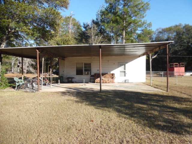
Perfect small cottage especially if you like/work at Kitty's Flea Market! 2 full lots fully chain link fenced. 1 Bedroom, open kitchen/living, three closets of hallway for linens, clothes and stuff. Shower unit only - no tub. 10' ceilings in kitchen/living. Front carport doubles as a covered patio. Old double wide front porch still onsite. Barn in back gives lots of storage. 2 window units - one NEW. Appliances stay. Laundry hook-up in utility room accessed on the side of the building.
Last Agent to Sell the Property
1 Key Realty LLC Brokerage Phone: 2298836155 License #163499 Listed on: 03/03/2017
Last Buyer's Agent
1 Key Realty LLC Brokerage Phone: 2298836155 License #163499 Listed on: 03/03/2017
| Date | Buyer | Sale Price | Title Company |
|---|---|---|---|
| Booth Donald J | $60,000 | -- | |
| Collier Donald W | $15,000 | -- | |
| Johnson June C | $15,400 | -- | |
| Collier Donald W | $23,000 | -- | |
| Rhodes Stephen B | $7,800 | -- | |
| Collier Donald W | -- | -- |
| Date | Event | Price | List to Sale | Price per Sq Ft |
|---|---|---|---|---|
| 03/07/2017 03/07/17 | Sold | $13,000 | -- | $18 / Sq Ft |
| 03/03/2017 03/03/17 | Pending | -- | -- | -- |
| Year | Tax Paid | Tax Assessment Tax Assessment Total Assessment is a certain percentage of the fair market value that is determined by local assessors to be the total taxable value of land and additions on the property. | Land | Improvement |
|---|---|---|---|---|
| 2024 | $721 | $15,600 | $5,040 | $10,560 |
| 2023 | $0 | $15,600 | $5,040 | $10,560 |
| 2022 | $485 | $15,600 | $5,040 | $10,560 |
| 2021 | $438 | $15,600 | $5,040 | $10,560 |
| 2020 | $439 | $15,600 | $5,040 | $10,560 |
| 2019 | $439 | $15,600 | $5,040 | $10,560 |
| 2018 | $49 | $15,600 | $5,040 | $10,560 |
| 2017 | $627 | $15,600 | $5,040 | $10,560 |
| 2016 | $356 | $15,600 | $5,040 | $10,560 |
| 2015 | $356 | $15,600 | $5,040 | $10,560 |
| 2014 | $349 | $15,600 | $5,040 | $10,560 |
Seller's Agent in 2017
Jackie Dixon
1 Key Realty LLC
(229) 344-5966
142 Total Sales
Source: Albany Board of REALTORS®
MLS Number: 137577
APN: 00138-00003-011