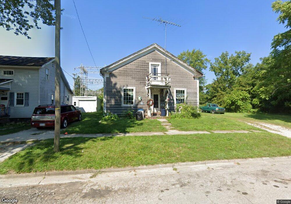
419 N Walnut St Bucyrus, OH 44820
Estimated Value: $86,000 - $187,000
3
Beds
2
Baths
1,312
Sq Ft
$91/Sq Ft
Est. Value
About This Home
This home is located at 419 N Walnut St, Bucyrus, OH 44820 and is currently estimated at $119,204, approximately $90 per square foot. 419 N Walnut St is a home located in Crawford County with nearby schools including Bucyrus Elementary School, Bucyrus Secondary School, and Holy Trinity School.
Ownership History
Date
Name
Owned For
Owner Type
Purchase Details
Closed on
Nov 29, 2010
Sold by
Brause Wayne E
Bought by
Kalb Andrew D
Current Estimated Value
Purchase Details
Closed on
May 29, 2009
Sold by
Miller Richard L and Miller Clara J
Bought by
Wayne E Bruase And Clara J Brause Family
Purchase Details
Closed on
Jul 9, 2008
Sold by
First Federal Community Bank Of Bucyrus and Gerber Phillip W
Bought by
Brause Wayne E and Brause Clara J
Purchase Details
Closed on
Oct 7, 2004
Bought by
First Federal Community
Create a Home Valuation Report for This Property
The Home Valuation Report is an in-depth analysis detailing your home's value as well as a comparison with similar homes in the area
Home Values in the Area
Average Home Value in this Area
Purchase History
| Date | Buyer | Sale Price | Title Company |
|---|---|---|---|
| Kalb Andrew D | $8,000 | -- | |
| Wayne E Bruase And Clara J Brause Family | -- | -- | |
| Brause Wayne E | $32,000 | -- | |
| First Federal Community | $5,300 | -- |
Source: Public Records
Tax History Compared to Growth
Tax History
| Year | Tax Paid | Tax Assessment Tax Assessment Total Assessment is a certain percentage of the fair market value that is determined by local assessors to be the total taxable value of land and additions on the property. | Land | Improvement |
|---|---|---|---|---|
| 2024 | $342 | $7,790 | $4,260 | $3,530 |
| 2023 | $342 | $2,910 | $2,080 | $830 |
| 2022 | $151 | $2,910 | $2,080 | $830 |
| 2021 | $151 | $2,910 | $2,080 | $830 |
| 2020 | $271 | $2,800 | $2,080 | $720 |
| 2019 | $314 | $2,800 | $2,080 | $720 |
| 2018 | $156 | $2,800 | $2,080 | $720 |
| 2017 | $161 | $2,800 | $2,080 | $720 |
| 2016 | $156 | $2,800 | $2,080 | $720 |
| 2015 | $154 | $2,800 | $2,080 | $720 |
| 2014 | $154 | $2,800 | $2,080 | $720 |
| 2013 | $154 | $2,800 | $2,080 | $720 |
Source: Public Records
Map
Nearby Homes
- 124 N Spring St
- 303 W Galen St
- 407 E Mansfield St
- 412 E Rensselaer St
- 511 Plymouth St
- 316 W Warren St
- 450 Sears St
- 517 Plymouth St
- 520 E Warren St
- 317 S Spring St
- 1221 N Sandusky Ave
- 444 Woodlawn Ave
- 711 Plymouth St
- 508 W Charles St
- 531 S Poplar St
- 550 S Walnut St
- 1018 Tiffin St
- 319 Sheckler St
- 346 Hopley Ave
- 325 W Liberty St
- 415 N Walnut St
- 429 N Walnut St
- 405 N Walnut St
- 124 E Perry St
- 124 E Perry St
- 416 N Walnut St
- 401 N Walnut St
- 430 N Walnut St
- 418 N Walnut St
- 424 N Walnut St
- 414 N Walnut St
- 426 N Walnut St
- 410 N Walnut St
- 0 E Perry St
- 406 N Walnut St
- 400 N Walnut St
- 404 N Walnut St
- 117 E Perry St
- 5066 Street
- 0 Brookside Dr Unit Lot 3 210018458