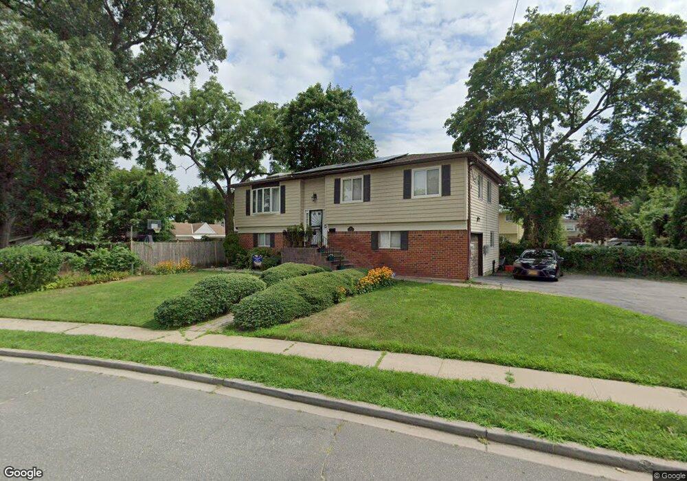
419 Rose Ave West Hempstead, NY 11552
Estimated Value: $746,000 - $821,606
4
Beds
3
Baths
2,057
Sq Ft
$381/Sq Ft
Est. Value
About This Home
This home is located at 419 Rose Ave, West Hempstead, NY 11552 and is currently estimated at $783,803, approximately $381 per square foot. 419 Rose Ave is a home located in Nassau County with nearby schools including Davison Avenue Intermediate School, Maurice W. Downing Primary K-2 School, and Howard T Herber Middle School.
Ownership History
Date
Name
Owned For
Owner Type
Purchase Details
Closed on
Dec 14, 2018
Sold by
Harehood Trust
Bought by
Demosthenes Schnahider and Demosthenes Aisha C
Current Estimated Value
Home Financials for this Owner
Home Financials are based on the most recent Mortgage that was taken out on this home.
Original Mortgage
$459,197
Outstanding Balance
$405,370
Interest Rate
4.9%
Mortgage Type
VA
Estimated Equity
$378,433
Purchase Details
Closed on
Jan 29, 2014
Sold by
Harewood Jean and Harewood Percival
Bought by
The Jean Harewood Irrevocable Trust
Create a Home Valuation Report for This Property
The Home Valuation Report is an in-depth analysis detailing your home's value as well as a comparison with similar homes in the area
Home Values in the Area
Average Home Value in this Area
Purchase History
| Date | Buyer | Sale Price | Title Company |
|---|---|---|---|
| Demosthenes Schnahider | $485,000 | None Available | |
| The Jean Harewood Irrevocable Trust | -- | Abstract Incorporated |
Source: Public Records
Mortgage History
| Date | Status | Borrower | Loan Amount |
|---|---|---|---|
| Open | Demosthenes Schnahider | $459,197 |
Source: Public Records
Tax History Compared to Growth
Tax History
| Year | Tax Paid | Tax Assessment Tax Assessment Total Assessment is a certain percentage of the fair market value that is determined by local assessors to be the total taxable value of land and additions on the property. | Land | Improvement |
|---|---|---|---|---|
| 2025 | $14,760 | $507 | $187 | $320 |
| 2024 | $5,000 | $507 | $187 | $320 |
| 2023 | $14,363 | $507 | $187 | $320 |
| 2022 | $14,363 | $507 | $187 | $320 |
| 2021 | $19,495 | $462 | $193 | $269 |
| 2020 | $15,261 | $752 | $468 | $284 |
| 2019 | $4,662 | $752 | $391 | $361 |
| 2018 | $5,279 | $901 | $0 | $0 |
| 2017 | $9,900 | $901 | $468 | $433 |
| 2016 | $14,970 | $901 | $468 | $433 |
| 2015 | $4,732 | $901 | $468 | $433 |
| 2014 | $4,732 | $901 | $468 | $433 |
| 2013 | $4,457 | $901 | $468 | $433 |
Source: Public Records
Map
Nearby Homes
- 450 Rhodes Ln
- 0 Rhodes Ln
- 841 Woodfield Rd
- 55 Melvin Ave
- 312 Coventry Rd S
- 301 Coventry Rd N
- 815 Sunshine Ave
- 486 Champlain Ave
- 924 Otsego Ct
- 853 Arthur St
- 899 Cleveland St
- 49 Carol St
- 5 Juliette Rd
- 1024 Mahopac Rd
- 7 Hopatcong Ave
- 919 Pinelake Dr
- 394 Pinebrook Ave
- 10 Pinebrook Ave
- 1070 Mahopac Rd
- 1025 Ontario Rd