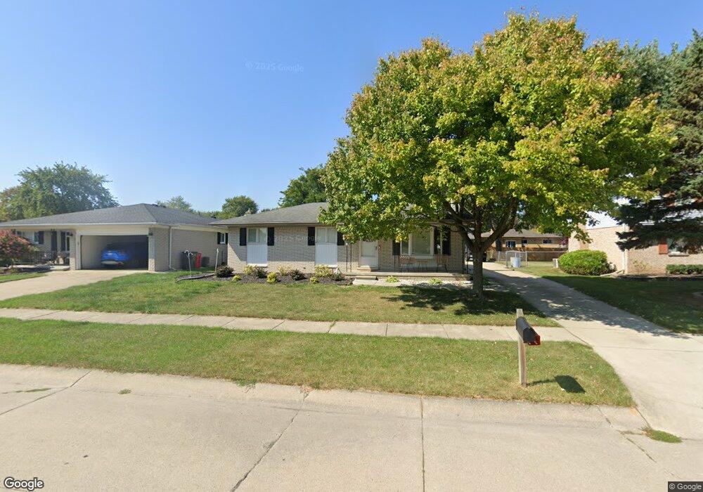
41977 Merrimac Cir Clinton Township, MI 48038
Estimated Value: $258,551 - $321,000
--
Bed
--
Bath
1,302
Sq Ft
$230/Sq Ft
Est. Value
About This Home
This home is located at 41977 Merrimac Cir, Clinton Township, MI 48038 and is currently estimated at $299,388, approximately $229 per square foot. 41977 Merrimac Cir is a home located in Macomb County with nearby schools including Erie Elementary School, Algonquin Middle School, and Chippewa Valley High School.
Ownership History
Date
Name
Owned For
Owner Type
Purchase Details
Closed on
Nov 7, 2024
Sold by
Martin Bernard
Bought by
Tappo Megan
Current Estimated Value
Purchase Details
Closed on
Jun 22, 2023
Sold by
Martin Bernard
Bought by
Martin Bernard and Needham Megan C
Home Financials for this Owner
Home Financials are based on the most recent Mortgage that was taken out on this home.
Original Mortgage
$176,600
Interest Rate
6.69%
Mortgage Type
New Conventional
Purchase Details
Closed on
Jun 12, 2023
Sold by
Bernard F Martin Sr And Rita T Martin Re
Bought by
Martin Bernard
Home Financials for this Owner
Home Financials are based on the most recent Mortgage that was taken out on this home.
Original Mortgage
$176,600
Interest Rate
6.69%
Mortgage Type
New Conventional
Purchase Details
Closed on
May 28, 1998
Sold by
Martin Bernard F and Martin Rita T
Bought by
Martin Bernard F and Martin Rita T
Create a Home Valuation Report for This Property
The Home Valuation Report is an in-depth analysis detailing your home's value as well as a comparison with similar homes in the area
Home Values in the Area
Average Home Value in this Area
Purchase History
| Date | Buyer | Sale Price | Title Company |
|---|---|---|---|
| Tappo Megan | -- | None Listed On Document | |
| Martin Bernard | -- | None Listed On Document | |
| Martin Bernard | -- | None Listed On Document | |
| Martin Bernard F | -- | -- |
Source: Public Records
Mortgage History
| Date | Status | Borrower | Loan Amount |
|---|---|---|---|
| Previous Owner | Martin Bernard | $176,600 |
Source: Public Records
Tax History Compared to Growth
Tax History
| Year | Tax Paid | Tax Assessment Tax Assessment Total Assessment is a certain percentage of the fair market value that is determined by local assessors to be the total taxable value of land and additions on the property. | Land | Improvement |
|---|---|---|---|---|
| 2025 | $3,276 | $136,200 | $0 | $0 |
| 2024 | $3,352 | $125,400 | $0 | $0 |
| 2023 | $1,851 | $109,200 | $0 | $0 |
| 2022 | $2,968 | $101,700 | $0 | $0 |
| 2021 | $2,887 | $96,400 | $0 | $0 |
| 2020 | $1,699 | $92,600 | $0 | $0 |
| 2019 | $2,689 | $87,200 | $0 | $0 |
| 2018 | $2,642 | $85,100 | $0 | $0 |
| 2017 | $2,610 | $79,900 | $16,200 | $63,700 |
| 2016 | $2,594 | $79,900 | $0 | $0 |
| 2015 | -- | $74,400 | $0 | $0 |
| 2014 | -- | $66,700 | $0 | $0 |
| 2011 | -- | $62,100 | $16,800 | $45,300 |
Source: Public Records
Map
Nearby Homes
- 42002 Coulon Dr
- 41992 Merrimac Cir
- 18960 Sandhurst Dr
- 41321 Chestnut Dr
- 41985 Dorchester Ct
- 20140 Shoals Ct Unit 16
- 42680 Chippewa Dr Unit 28
- 41704 Clinton Pines Dr
- 19790 Westchester Dr Unit 11
- 41217 Fortuna Dr E
- 19821 Woodview Dr
- 41201 Whispering Oaks Dr Unit 17
- 20330 Rambling Dr
- 42266 Brookview Ln Unit 1
- 42407 Creekside Dr Unit 165
- 42328 Sheridan Ct
- 40772 Michael St
- 0 Clinton River Rd Unit 20251013874
- 42109 Hidden Brook Dr Unit 52
- 42201 Hidden Brook Dr Unit 68
- 41991 Merrimac Cir
- 41963 Merrimac Cir
- 41884 Coulon Dr
- 42005 Merrimac Cir
- 41949 Merrimac Cir
- 41898 Coulon Dr
- 41870 Coulon Dr
- 41978 Merrimac Cir
- 41856 Coulon Dr
- 41964 Merrimac Cir Unit Bldg-Unit
- 41964 Merrimac Cir
- 42021 Merrimac Cir
- 41935 Merrimac Cir
- 41952 Merrimac Cir
- 41842 Coulon Dr
- 42006 Merrimac Cir Unit Bldg-Unit
- 42006 Merrimac Cir
- 42014 Coulon Dr
- 41938 Merrimac Cir
- 42039 Merrimac Cir