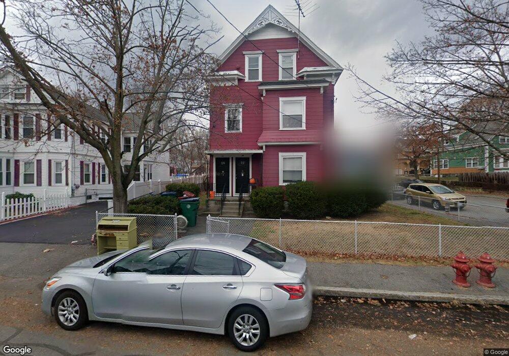
42 3rd Ave Lowell, MA 01854
Pawtucketville NeighborhoodEstimated Value: $715,000 - $770,000
8
Beds
3
Baths
3,056
Sq Ft
$246/Sq Ft
Est. Value
About This Home
This home is located at 42 3rd Ave, Lowell, MA 01854 and is currently estimated at $751,333, approximately $245 per square foot. 42 3rd Ave is a home located in Middlesex County with nearby schools including Joseph McAvinnue Elementary School, Charlotte M. Murkland Elementary School, and Charles W. Morey Elementary School.
Ownership History
Date
Name
Owned For
Owner Type
Purchase Details
Closed on
Jan 11, 2018
Sold by
King Elisa B
Bought by
Elisa B King Irt and King
Current Estimated Value
Purchase Details
Closed on
Feb 22, 2010
Sold by
Murphy Kevin and King John J
Bought by
King Elisa B
Purchase Details
Closed on
Dec 29, 1983
Bought by
King Elisa B
Create a Home Valuation Report for This Property
The Home Valuation Report is an in-depth analysis detailing your home's value as well as a comparison with similar homes in the area
Home Values in the Area
Average Home Value in this Area
Purchase History
| Date | Buyer | Sale Price | Title Company |
|---|---|---|---|
| Elisa B King Irt | -- | -- | |
| Elisa B King Irt | -- | -- | |
| King Elisa B | -- | -- | |
| King Elisa B | -- | -- | |
| King Elisa B | $64,000 | -- |
Source: Public Records
Tax History
| Year | Tax Paid | Tax Assessment Tax Assessment Total Assessment is a certain percentage of the fair market value that is determined by local assessors to be the total taxable value of land and additions on the property. | Land | Improvement |
|---|---|---|---|---|
| 2025 | $7,438 | $647,900 | $164,900 | $483,000 |
| 2024 | $6,979 | $586,000 | $143,800 | $442,200 |
| 2023 | $6,737 | $542,400 | $119,500 | $422,900 |
| 2022 | $6,255 | $492,900 | $108,600 | $384,300 |
| 2021 | $5,434 | $403,700 | $94,500 | $309,200 |
| 2020 | $4,938 | $369,600 | $88,300 | $281,300 |
| 2019 | $4,795 | $341,500 | $81,700 | $259,800 |
| 2018 | $4,396 | $305,500 | $77,900 | $227,600 |
| 2017 | $4,164 | $279,100 | $70,800 | $208,300 |
| 2016 | $3,464 | $228,500 | $59,300 | $169,200 |
| 2015 | $3,322 | $214,600 | $60,700 | $153,900 |
| 2013 | $3,035 | $202,200 | $74,900 | $127,300 |
Source: Public Records
Map
Nearby Homes
- 89 Mammoth Rd
- 30 4th Ave
- 81 4th Ave
- 104 Woodward Ave
- 38 Starbird St
- 105 Columbia Rd
- 187 Varnum Ave
- 101 Dracut St
- 113 School St Unit 12
- 39 Phoebe Ave
- 100 W Meadow Rd
- 19 Oliver St
- 169 Salem St
- 116 Walker St
- 1720 Skyline Dr Unit 15
- 2200 Skyline Dr Unit 4
- 70 Austin St Unit 15
- 15 Barbara St
- 94 Hampson St
- 129 Cabot St
Your Personal Tour Guide
Ask me questions while you tour the home.