Estimated Value: $825,202 - $1,002,000
4
Beds
3
Baths
2,194
Sq Ft
$409/Sq Ft
Est. Value
About This Home
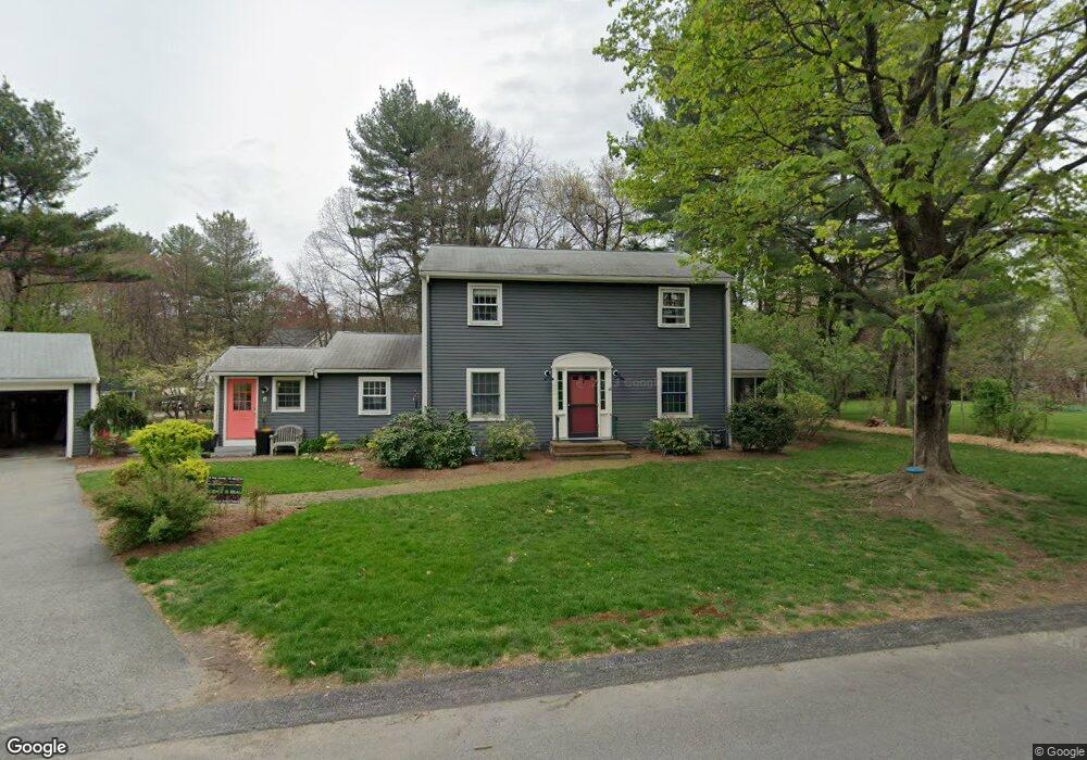
This home is located at 42 Agawam Rd, Acton, MA 01720 and is currently estimated at $898,051, approximately $409 per square foot. 42 Agawam Rd is a home located in Middlesex County with nearby schools including Acton-Boxborough Regional High School.
Ownership History
Date
Name
Owned For
Owner Type
Purchase Details
Closed on
Dec 12, 2014
Sold by
Tveskov Michael and Lux Virginia A
Bought by
Richmond 4Th Warren H and Richmond Emily G
Current Estimated Value
Home Financials for this Owner
Home Financials are based on the most recent Mortgage that was taken out on this home.
Original Mortgage
$424,000
Outstanding Balance
$330,480
Interest Rate
3.98%
Mortgage Type
New Conventional
Estimated Equity
$567,571
Purchase Details
Closed on
Aug 6, 2003
Sold by
Harris Craig S
Bought by
Apple Valley Homes Inc
Purchase Details
Closed on
Sep 18, 2002
Sold by
Tveskov Michael and Lux Virginia A
Bought by
Harris Craig S
Purchase Details
Closed on
Apr 26, 1996
Sold by
Flaherty Elaine G
Bought by
Tveskov Michael and Lux Virginia A
Create a Home Valuation Report for This Property
The Home Valuation Report is an in-depth analysis detailing your home's value as well as a comparison with similar homes in the area
Home Values in the Area
Average Home Value in this Area
Purchase History
| Date | Buyer | Sale Price | Title Company |
|---|---|---|---|
| Richmond 4Th Warren H | $530,000 | -- | |
| Apple Valley Homes Inc | $216,000 | -- | |
| Harris Craig S | $25,000 | -- | |
| Tveskov Michael | $245,000 | -- |
Source: Public Records
Mortgage History
| Date | Status | Borrower | Loan Amount |
|---|---|---|---|
| Open | Richmond 4Th Warren H | $424,000 | |
| Previous Owner | Tveskov Michael | $181,000 | |
| Previous Owner | Tveskov Michael | $30,000 | |
| Previous Owner | Tveskov Michael | $159,500 |
Source: Public Records
Tax History Compared to Growth
Tax History
| Year | Tax Paid | Tax Assessment Tax Assessment Total Assessment is a certain percentage of the fair market value that is determined by local assessors to be the total taxable value of land and additions on the property. | Land | Improvement |
|---|---|---|---|---|
| 2025 | $12,098 | $705,400 | $320,900 | $384,500 |
| 2024 | $11,356 | $681,200 | $320,900 | $360,300 |
| 2023 | $11,056 | $629,600 | $291,700 | $337,900 |
| 2022 | $10,659 | $548,000 | $253,600 | $294,400 |
| 2021 | $10,394 | $513,800 | $234,800 | $279,000 |
| 2020 | $9,803 | $509,500 | $234,800 | $274,700 |
| 2019 | $9,334 | $481,900 | $234,800 | $247,100 |
| 2018 | $9,192 | $474,300 | $234,800 | $239,500 |
| 2017 | $8,966 | $470,400 | $234,800 | $235,600 |
| 2016 | $8,827 | $459,000 | $234,800 | $224,200 |
| 2015 | $8,679 | $455,600 | $234,800 | $220,800 |
| 2014 | $8,451 | $434,500 | $234,800 | $199,700 |
Source: Public Records
Map
Nearby Homes
- 5 Elm St Unit 1
- 285 Central St Unit 285
- 4 Huron Rd
- 116 Windsor Ave
- 246 Main St Unit 2
- 4,7,8 Crestwood Ln
- 92 Willow St Unit 3
- 92 Willow St Unit 2
- 90 Willow St Unit 1
- 7 Kelley Rd
- 11 Braebrook
- 46 Taylor Rd
- 19 Railroad St Unit D2
- 19 Railroad St Unit C2
- 129 Main St Unit 129
- 131 Main St
- 33 Meadowbrook Rd
- 491 Main St
- 4 Omega Way
- 40 High St