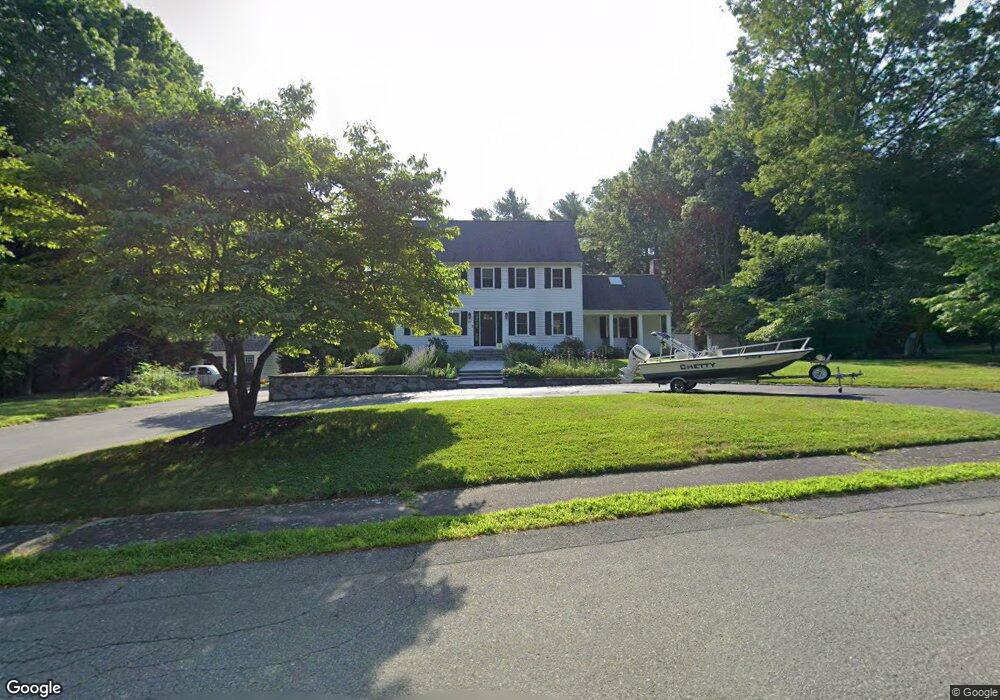
42 Benjamins Path Pembroke, MA 02359
Estimated Value: $870,594 - $900,000
4
Beds
3
Baths
2,484
Sq Ft
$356/Sq Ft
Est. Value
About This Home
This home is located at 42 Benjamins Path, Pembroke, MA 02359 and is currently estimated at $884,399, approximately $356 per square foot. 42 Benjamins Path is a home located in Plymouth County with nearby schools including Pembroke High School, Cadence Academy Preschool - Hanover, and Cardinal Cushing Centers.
Ownership History
Date
Name
Owned For
Owner Type
Purchase Details
Closed on
Nov 21, 2012
Sold by
Souretis Joseph A and Souretis Christina M
Bought by
Souretis Ft and Souretis Joseph A
Current Estimated Value
Purchase Details
Closed on
May 30, 2008
Sold by
Dougherty Kevin P
Bought by
Souretis Joseph A and Souretis Christina M
Purchase Details
Closed on
Mar 15, 1996
Sold by
Spath Phillip and Spath Celeste
Bought by
Dougherty Kevin P
Purchase Details
Closed on
Jun 29, 1990
Sold by
Riker Douglas M
Bought by
Spath Phillip
Purchase Details
Closed on
May 1, 1987
Sold by
Anderson Nancy
Bought by
Riker Douglas M
Create a Home Valuation Report for This Property
The Home Valuation Report is an in-depth analysis detailing your home's value as well as a comparison with similar homes in the area
Home Values in the Area
Average Home Value in this Area
Purchase History
| Date | Buyer | Sale Price | Title Company |
|---|---|---|---|
| Souretis Ft | -- | -- | |
| Souretis Joseph A | $400,000 | -- | |
| Dougherty Kevin P | $239,000 | -- | |
| Spath Phillip | $257,000 | -- | |
| Riker Douglas M | $269,000 | -- |
Source: Public Records
Mortgage History
| Date | Status | Borrower | Loan Amount |
|---|---|---|---|
| Previous Owner | Riker Douglas M | $355,500 |
Source: Public Records
Tax History Compared to Growth
Tax History
| Year | Tax Paid | Tax Assessment Tax Assessment Total Assessment is a certain percentage of the fair market value that is determined by local assessors to be the total taxable value of land and additions on the property. | Land | Improvement |
|---|---|---|---|---|
| 2025 | $8,807 | $732,700 | $325,600 | $407,100 |
| 2024 | $8,711 | $724,100 | $320,400 | $403,700 |
| 2023 | $8,277 | $650,700 | $295,600 | $355,100 |
| 2022 | $7,822 | $552,800 | $235,500 | $317,300 |
| 2021 | $7,761 | $532,300 | $230,300 | $302,000 |
| 2020 | $7,586 | $523,500 | $230,300 | $293,200 |
| 2019 | $7,290 | $499,300 | $220,300 | $279,000 |
| 2018 | $7,162 | $481,000 | $220,300 | $260,700 |
| 2017 | $7,009 | $464,200 | $205,500 | $258,700 |
| 2016 | $6,881 | $450,900 | $195,500 | $255,400 |
| 2015 | $6,040 | $409,800 | $185,500 | $224,300 |
Source: Public Records
Map
Nearby Homes
- 330 Pleasant St
- 387 North St
- 33 Barker Square Dr Unit 33
- 40 Brisan Way
- 61 North St
- 30 Old Washington St Unit 9
- 261 Washington St
- 218 Schoosett St
- 100 Fairwood Dr
- 5 Royal Dane Dr Unit 46
- 5 Royal Dane Dr Unit 45
- 99 Old Washington St
- 451 School St Unit 5-2
- 451 School St Unit 3-4
- 21 Union St
- 14 Red Pony Path
- 2 Proprietors Dr Unit 23
- 19 Hayloft Ln
- 2 Secret Pond Way Unit 35
- 1 Secret Pond Way Unit 36