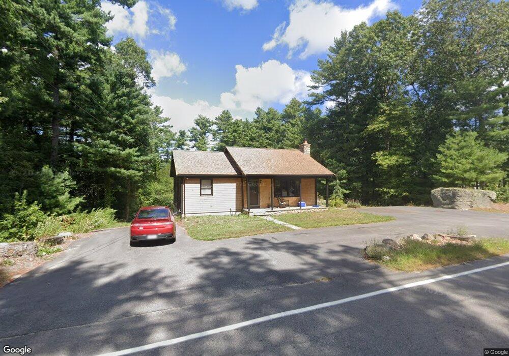
42 Chace Rd East Freetown, MA 02717
Estimated Value: $503,389 - $531,000
2
Beds
2
Baths
864
Sq Ft
$598/Sq Ft
Est. Value
About This Home
This home is located at 42 Chace Rd, East Freetown, MA 02717 and is currently estimated at $516,597, approximately $597 per square foot. 42 Chace Rd is a home located in Bristol County with nearby schools including Freetown Elementary School, George R Austin Intermediate School, and Freetown-Lakeville Middle School.
Ownership History
Date
Name
Owned For
Owner Type
Purchase Details
Closed on
Feb 21, 2008
Sold by
Hagar David M
Bought by
Pelletier Thomas M
Current Estimated Value
Home Financials for this Owner
Home Financials are based on the most recent Mortgage that was taken out on this home.
Original Mortgage
$233,157
Interest Rate
5.9%
Mortgage Type
Purchase Money Mortgage
Purchase Details
Closed on
Feb 16, 1999
Sold by
Loranger Ronald A
Bought by
Hagar David M
Home Financials for this Owner
Home Financials are based on the most recent Mortgage that was taken out on this home.
Original Mortgage
$124,200
Interest Rate
6.78%
Mortgage Type
Purchase Money Mortgage
Purchase Details
Closed on
Sep 28, 1994
Sold by
Whitehead Gladys
Bought by
Loranger Ronald A
Home Financials for this Owner
Home Financials are based on the most recent Mortgage that was taken out on this home.
Original Mortgage
$99,750
Interest Rate
8.5%
Mortgage Type
Purchase Money Mortgage
Create a Home Valuation Report for This Property
The Home Valuation Report is an in-depth analysis detailing your home's value as well as a comparison with similar homes in the area
Home Values in the Area
Average Home Value in this Area
Purchase History
| Date | Buyer | Sale Price | Title Company |
|---|---|---|---|
| Pelletier Thomas M | $235,000 | -- | |
| Hagar David M | $123,000 | -- | |
| Loranger Ronald A | $105,000 | -- |
Source: Public Records
Mortgage History
| Date | Status | Borrower | Loan Amount |
|---|---|---|---|
| Open | Loranger Ronald A | $216,971 | |
| Closed | Pelletier Thomas M | $233,157 | |
| Previous Owner | Loranger Ronald A | $10,000 | |
| Previous Owner | Loranger Ronald A | $124,200 | |
| Previous Owner | Loranger Ronald A | $99,750 |
Source: Public Records
Tax History Compared to Growth
Tax History
| Year | Tax Paid | Tax Assessment Tax Assessment Total Assessment is a certain percentage of the fair market value that is determined by local assessors to be the total taxable value of land and additions on the property. | Land | Improvement |
|---|---|---|---|---|
| 2025 | $3,728 | $376,200 | $156,900 | $219,300 |
| 2024 | $3,705 | $355,200 | $148,000 | $207,200 |
| 2023 | $3,605 | $336,600 | $133,300 | $203,300 |
| 2022 | $3,455 | $286,500 | $112,900 | $173,600 |
| 2021 | $3,360 | $264,600 | $102,700 | $161,900 |
| 2020 | $3,329 | $255,700 | $98,800 | $156,900 |
| 2019 | $3,164 | $240,600 | $94,000 | $146,600 |
| 2018 | $3,048 | $229,000 | $94,000 | $135,000 |
| 2017 | $2,974 | $223,300 | $94,000 | $129,300 |
| 2016 | $2,818 | $215,300 | $91,300 | $124,000 |
| 2015 | $2,571 | $199,300 | $91,300 | $108,000 |
| 2014 | $2,417 | $191,700 | $89,500 | $102,200 |
Source: Public Records
Map
Nearby Homes
- 0 Costa Dr
- 144 Chace Rd
- 9 Paul Ave
- 24 Bells Brook Rd
- 4597 Acushnet Ave
- 1475 Braley Rd Unit 17
- 599 Quanapoag Rd
- 195 Slab Bridge Rd
- 5 Freetown St
- 269 Middleboro Rd
- 13 Luscomb Ln
- 16 Swallow St
- 1069 Cherokee St
- 319 Northwest St
- 3 Abraham Ave
- 15 Morrison Way
- 120 Hackett Ave
- 150 Quanapoag Rd
- 64 Blaze Rd
- 60 Lakeside Ave