$196,000

42 Dwelly Point Rd Franklin, ME 04634

Estimated payment $1,245/month

Total Views 2,670
3.31 Acres
$59,215 Price per Acre
144,184 Sq Ft Lot

Highlights

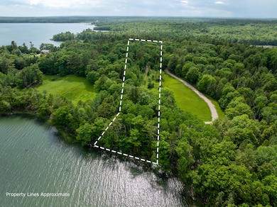
  • 217 Feet of Waterfront
  • Wooded Lot
  • Open Lot
  • Access to Tidal Water
  • Pasture

About This Lot

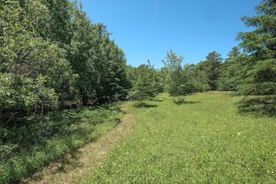
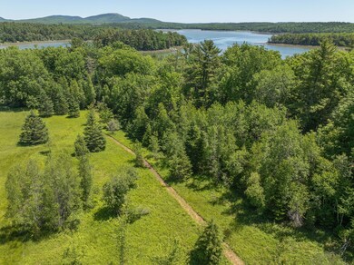
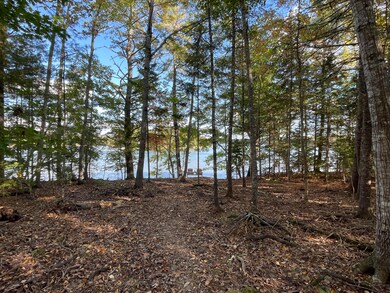
Discover Franklin's Dwelly Point, a quiet and private peninsula jutting out into scenic Taunton Bay. Each of the lots on Dwelly Point are designed to create space and privacy between neighbors. These 3.3 Acres feature open meadow, mixed hardwood and coniferous trees and over 200' of shoreline with sea grasses, granite stones and mature oaks. Recent work has opened up the view to the bay while keeping the character and diversity of the trees. Launch a kayak or paddleboard from your shorefront or from the common area at the tip of the peninsula available to the residents of Dwelly Point. Here you'll find a boat launch, sitting areas and a kayak storage rack. While rural and tranquil, Ellsworth is only 18 minutes away, Bar Harbor 45 min., Bangor Intl Airport 1hr 30 mins. With a driveway and leach field already in place, take the next steps to create your home on this beautiful land.

Last Listed By

David Olsen

The Island Agency Listed on: 04/15/2025

Property Details

Property Type

  • Land

Est. Annual Taxes

  • $1,503

Lot Details

  • 3.31 Acre Lot
  • 217 Feet of Waterfront
  • Ocean Front
  • Property Fronts a Bay or Harbor
  • Street terminates at a dead end
  • Rural Setting
  • Open Lot
  • Wooded Lot
  • Property is zoned Shoreland

HOA Fees

  • $25 Monthly HOA Fees

Property Views

  • Water
  • Scenic Vista
  • Woods

Farming

  • Pasture

Utilities

  • Electricity Not Available
  • Natural Gas Not Available
  • Water Not Available
  • Septic Tank
  • Septic Design Available

Listing and Financial Details

  • Tax Lot 25
  • Assessor Parcel Number FRKL-000015-000000-000025

Community Details

Overview

  • The community has rules related to deed restrictions

Recreation

  • Access to Tidal Water

Property Details

Property Type

Land

Est. Annual Taxes

$1,503

Lot Details

0

HOA Fees

$25 per month

Listing Details

  • Prop. Type: Land
  • Lot Size Acres: 3.31
  • Road Frontage Type: Private Road
  • Road Surface Type: Paved
  • Water Body Name: Mt Desert Narrows
  • MLS Status: Active
  • Subdivision Name: Yes
  • Directions: From High Street in Ellsworth take Route 1 4.7 mi. East toward Hancock. Turn Left on Route 182 to Franklin. Continue 5.5 mi. to Dwelley Point Road on the right. A sign is on the property 0.4 mi down the road on the left.
  • Property Information:Lot Size Acres -: 3.31
  • Site:Open: Yes
  • Water Info:Water Frontage2: Yes
  • Water Info:Water View2: Yes
  • Location Information:Association Fee: 300.0
  • Location Information:Fee Frequency Paid: Annually
  • Gas:No Gas: Yes
  • Property Information:Short Sale Continue to Show: No
  • Recreational Water:Oceanfront: Yes
  • Location:Rural: Yes
  • Roads:Dead End: Yes
  • Water Info:Waterfront Amount -: 217.0
  • Water Info:Water Frontage Owned -: 217.0
  • Site:Wooded: Yes
  • View:TreesWoods: Yes
  • Property Information:Deed Restrictions: Yes
  • Property Information:Bank Owned REO: No
  • Sewer:Septic Design Available: Yes
  • View:Scenic: Yes
  • Property Information:Mobile Homes Allowed: No
  • View:Fields: Yes
  • Electric:No Electric: Yes
  • Recreational Water:Waterfront Tidal: Yes
  • Site:PastureField: Yes
  • Water Info:Island3: No
  • Special Features: None
  • Property Sub Type: LotsLands

Exterior Features

  • Lot Features: Pasture/Field, Open, Wooded, Neighborhood, Rural, Subdivided
  • View: Fields, Scenic, Trees/Woods
  • Waterfront Features: Bay
  • Waterfront: Yes

Garage/Parking

  • Parking Features: 1 - 4 Spaces, Other

Utilities

  • Electric: No Electric
  • Sewer: Septic Tank, Septic Design Available
  • Water Source: None

Condo/Co-op/Association

  • Association Fee: 300.0
  • Association Fee Frequency: Annually
  • Association: Yes
  • Pets Allowed: Other Restrictions

Schools

  • Junior High Dist: RSU 24

Lot Info

  • Lot Size Sq Ft: 144183.6
  • Parcel #: FRKL-000015-000000-000025
  • Zoning: Shoreland

Tax Info

  • Tax Annual Amount: 1503.0
  • Tax Book Number: 7094
  • Tax Lot: 25
  • Tax Map Number: 15
  • Tax Year: 2024

Map

Range of Values:

Collateral Analytics

Collateral Analytics Collateral Analytics AVMs (Automated Valuation Model) employ a number of statistical approaches combined with neighborhood-specific comparable selection guarantees the most up-to-date and precise valuations.

Not Available

Collateral Analytics does not have data for the current month. Please view the chart for historical values.

ICE

ICE Mortgage Technology ICE Mortgage Technology’s AVM (Automated Valuation Model) is a state-of-the-art online residential property valuation tool that provides a quick and accurate estimate of the value of almost any home in the U.S.

Not Available

ICE Mortgage Technology does not have data for the current month. Please view the chart for historical values.

First American

First American First American Data & Analytics’ next-generation AVM combines unrivaled data assets with a blended ensemble of valuation models to produce highly accurate, reliable valuations you can trust.

Not Available

First American does not have data for the current month. Please view the chart for historical values.

Quantarium

Quantarium Quantarium’s valuation service, repeatedly proven the industry’s most accurate and comprehensive, is supercharged with a self-learning and auto-tuning AI engine that continually becomes smarter and more accurate as it processes daily inputs from the industry’s leading RE data lake.

Not Available

Quantarium does not have data for the current month. Please view the chart for historical values.

Average Value
Not Available
List Price
Sold Price
Create a Home Valuation Report for This Property
The Home Valuation Report is an in-depth analysis detailing your home's value as well as a comparison with similar homes in the area

Home Values in the Area

Source: Public Records

Average Home Value in this Area


Source: Public Records

Tax History

Year Tax Paid Tax Assessment Tax Assessment Total Assessment is a certain percentage of the fair market value that is determined by local assessors to be the total taxable value of land and additions on the property. Land Improvement
2024 $1,503 $115,600 $115,600 $0
2023 $1,503 $115,600 $115,600 $0
2022 $1,480 $115,600 $115,600 $0
2021 $1,367 $99,090 $99,090 $0
2020 $1,358 $99,090 $99,090 $0
2019 $1,358 $99,090 $99,090 $0
2018 $1,358 $99,090 $99,090 $0
2017 $1,338 $99,090 $99,090 $0
2016 $1,189 $99,090 $99,090 $0
2015 $1,011 $99,090 $99,090 $0
2014 $941 $99,100 $99,100 $0
2013 $961 $99,100 $99,100 $0
Source: Public Records

Property History

Date Event Price Change Sq Ft Price
04/15/2025 04/15/25 For Sale $196,000 -- --
Source: Maine Listings

Source: Maine Listings

MLS Number: 1619078

Maine Listings