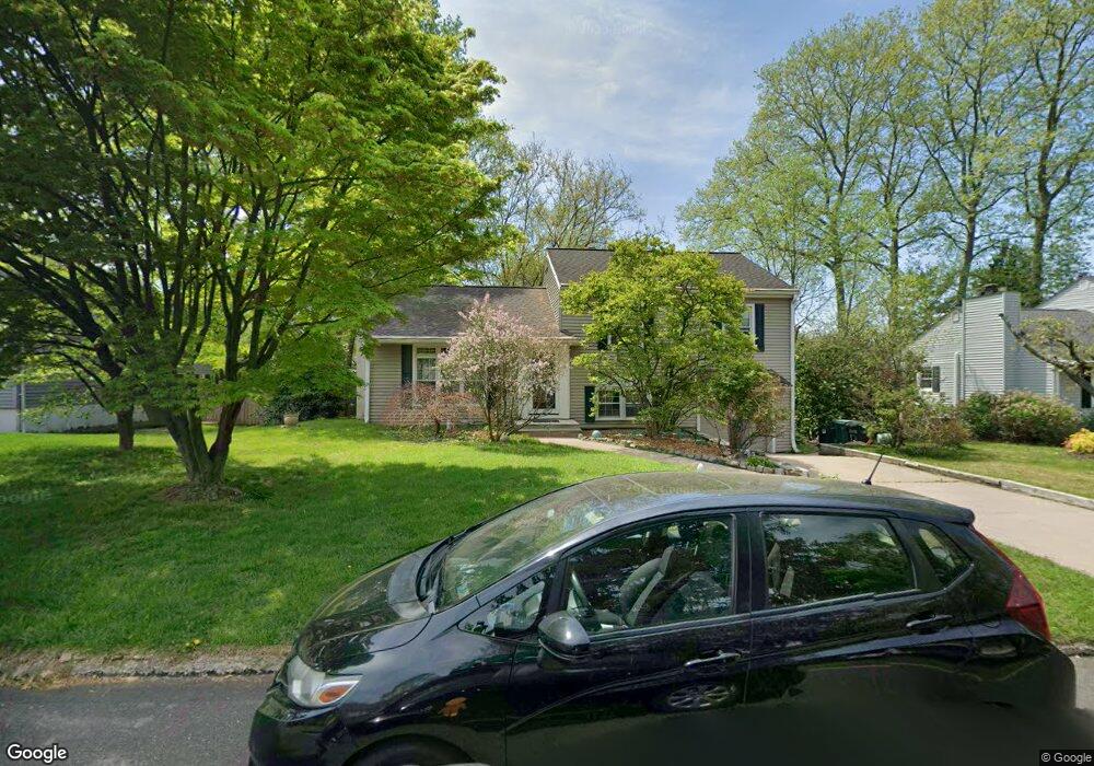
42 Laubert Rd Conshohocken, PA 19428
Estimated Value: $482,928 - $530,000
3
Beds
2
Baths
1,482
Sq Ft
$341/Sq Ft
Est. Value
About This Home
This home is located at 42 Laubert Rd, Conshohocken, PA 19428 and is currently estimated at $505,232, approximately $340 per square foot. 42 Laubert Rd is a home located in Montgomery County with nearby schools including Ridge Park Elementary School, Colonial Elementary School, and Colonial Middle School.
Ownership History
Date
Name
Owned For
Owner Type
Purchase Details
Closed on
Apr 5, 2016
Sold by
Lavalley Brett and Lavalley Kiely Hall
Bought by
Lavalley Brett and Lavalley Kiely Hall
Current Estimated Value
Home Financials for this Owner
Home Financials are based on the most recent Mortgage that was taken out on this home.
Original Mortgage
$239,000
Outstanding Balance
$189,871
Interest Rate
3.68%
Mortgage Type
New Conventional
Estimated Equity
$315,361
Purchase Details
Closed on
Feb 9, 2007
Sold by
Fancher Roderick M
Bought by
Lavalley Brett and Hall Kiely
Home Financials for this Owner
Home Financials are based on the most recent Mortgage that was taken out on this home.
Original Mortgage
$262,400
Interest Rate
6.27%
Create a Home Valuation Report for This Property
The Home Valuation Report is an in-depth analysis detailing your home's value as well as a comparison with similar homes in the area
Home Values in the Area
Average Home Value in this Area
Purchase History
| Date | Buyer | Sale Price | Title Company |
|---|---|---|---|
| Lavalley Brett | -- | Quality Abstract Services | |
| Lavalley Brett | $328,000 | None Available |
Source: Public Records
Mortgage History
| Date | Status | Borrower | Loan Amount |
|---|---|---|---|
| Open | Lavalley Brett | $239,000 | |
| Previous Owner | Lavalley Brett | $262,400 |
Source: Public Records
Tax History Compared to Growth
Tax History
| Year | Tax Paid | Tax Assessment Tax Assessment Total Assessment is a certain percentage of the fair market value that is determined by local assessors to be the total taxable value of land and additions on the property. | Land | Improvement |
|---|---|---|---|---|
| 2025 | $4,184 | $128,500 | $48,160 | $80,340 |
| 2024 | $4,184 | $128,500 | $48,160 | $80,340 |
| 2023 | $4,033 | $128,500 | $48,160 | $80,340 |
| 2022 | $3,941 | $128,500 | $48,160 | $80,340 |
| 2021 | $3,823 | $128,500 | $48,160 | $80,340 |
| 2020 | $3,683 | $128,500 | $48,160 | $80,340 |
| 2019 | $3,573 | $128,500 | $48,160 | $80,340 |
| 2018 | $996 | $128,500 | $48,160 | $80,340 |
| 2017 | $3,450 | $128,500 | $48,160 | $80,340 |
| 2016 | $3,400 | $128,500 | $48,160 | $80,340 |
| 2015 | $3,342 | $128,500 | $48,160 | $80,340 |
| 2014 | $3,251 | $128,500 | $48,160 | $80,340 |
Source: Public Records
Map
Nearby Homes
- 2017 Spring Mill Rd
- 117 Karrs Ln
- 10 Maple Dr
- 1705 Harmon Rd
- 2150 Julia Dr
- 264 Roberts Ave Unit 10
- 1975 West Ave
- 35 White Pine Ct
- 2134 Birch Dr
- 7 Plum Ct
- 1410 Butler Pike
- 1408 Butler Pike
- 411 Roberts Ave
- 10 Gum Tree Rd
- 25 E Germantown Pike
- 4004 School House Ln
- 1004 Aspen Ct
- 121 Scarlet Dr
- 140 W 11th Ave
- 253 E 10th Ave