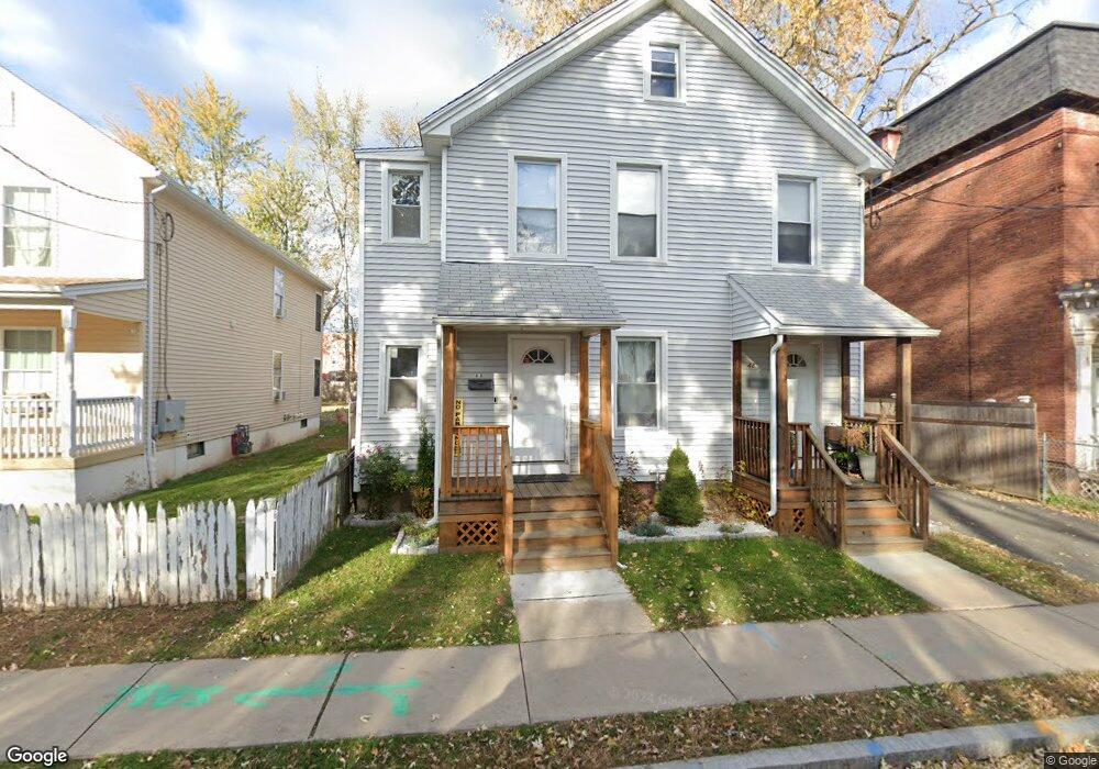
42 Liberty St Hartford, CT 06120
Clay Arsenal NeighborhoodEstimated Value: $187,000 - $280,000
6
Beds
2
Baths
2,431
Sq Ft
$99/Sq Ft
Est. Value
About This Home
This home is located at 42 Liberty St, Hartford, CT 06120 and is currently estimated at $241,817, approximately $99 per square foot. 42 Liberty St is a home located in Hartford County with nearby schools including Capital Preparatory Magnet School, Perry Elementary School, and Ib Global Communications Academy.
Ownership History
Date
Name
Owned For
Owner Type
Purchase Details
Closed on
Apr 12, 2023
Sold by
Byrum Michelle L
Bought by
Henry Harold
Current Estimated Value
Purchase Details
Closed on
Oct 22, 2008
Sold by
Us Bank Na
Bought by
Byrum Michelle
Purchase Details
Closed on
Dec 21, 1987
Sold by
Sugulleh Hassan A
Bought by
Compass Warren
Create a Home Valuation Report for This Property
The Home Valuation Report is an in-depth analysis detailing your home's value as well as a comparison with similar homes in the area
Home Values in the Area
Average Home Value in this Area
Purchase History
| Date | Buyer | Sale Price | Title Company |
|---|---|---|---|
| Henry Harold | $60,000 | None Available | |
| Byrum Michelle | $31,500 | -- | |
| Compass Warren | $104,000 | -- |
Source: Public Records
Mortgage History
| Date | Status | Borrower | Loan Amount |
|---|---|---|---|
| Previous Owner | Compass Warren | $25,000 | |
| Previous Owner | Compass Warren | $133,450 | |
| Previous Owner | Compass Warren | $78,750 |
Source: Public Records
Tax History Compared to Growth
Tax History
| Year | Tax Paid | Tax Assessment Tax Assessment Total Assessment is a certain percentage of the fair market value that is determined by local assessors to be the total taxable value of land and additions on the property. | Land | Improvement |
|---|---|---|---|---|
| 2025 | $4,237 | $61,446 | $3,675 | $57,771 |
| 2024 | $4,237 | $61,446 | $3,675 | $57,771 |
| 2023 | $4,237 | $61,446 | $3,675 | $57,771 |
| 2022 | $4,237 | $61,446 | $3,675 | $57,771 |
| 2021 | $3,926 | $52,850 | $3,290 | $49,560 |
| 2020 | $3,926 | $52,850 | $3,290 | $49,560 |
| 2019 | $3,926 | $52,850 | $3,290 | $49,560 |
| 2018 | $3,794 | $51,068 | $3,179 | $47,889 |
| 2016 | $3,515 | $47,316 | $3,027 | $44,289 |
| 2015 | $3,348 | $45,069 | $2,884 | $42,185 |
| 2014 | $3,266 | $43,967 | $2,813 | $41,154 |
Source: Public Records
Map
Nearby Homes
- 300 Garden St
- 33 Sargeant St
- 6 Magnolia St
- 116 Fairmount St
- 59 Magnolia St
- 10 Burton St Unit 12
- 96 Sargeant St Unit 98
- 5 Winter St
- 62 Burton St
- 410 Garden St
- 152 Brook St
- 47 Seyms St
- 134 Magnolia St Unit 136
- 66 Edgewood St Unit 68
- 183 Brook St Unit 185
- 186 Brook St Unit 188
- 25 May St
- 78-80 Cabot St
- 68 Enfield St Unit 70
- 251 Collins St
- 40 Liberty St
- 44 Liberty St Unit 46
- 48 Liberty St
- 38 Liberty St
- 36 Liberty St
- 50 Liberty St
- 15 Brook St Unit 17
- 52 Liberty St
- 43 Liberty St
- 22 Bedford St
- 19 Brook St Unit 21
- 29-31 Liberty St
- 33 Liberty St
- 49 Liberty St
- 26 Bedford St
- 26 Liberty St
- 23 Brook St
- 16 Bedford St Unit 1
- 16 Bedford St
- 29 Liberty St Unit 31