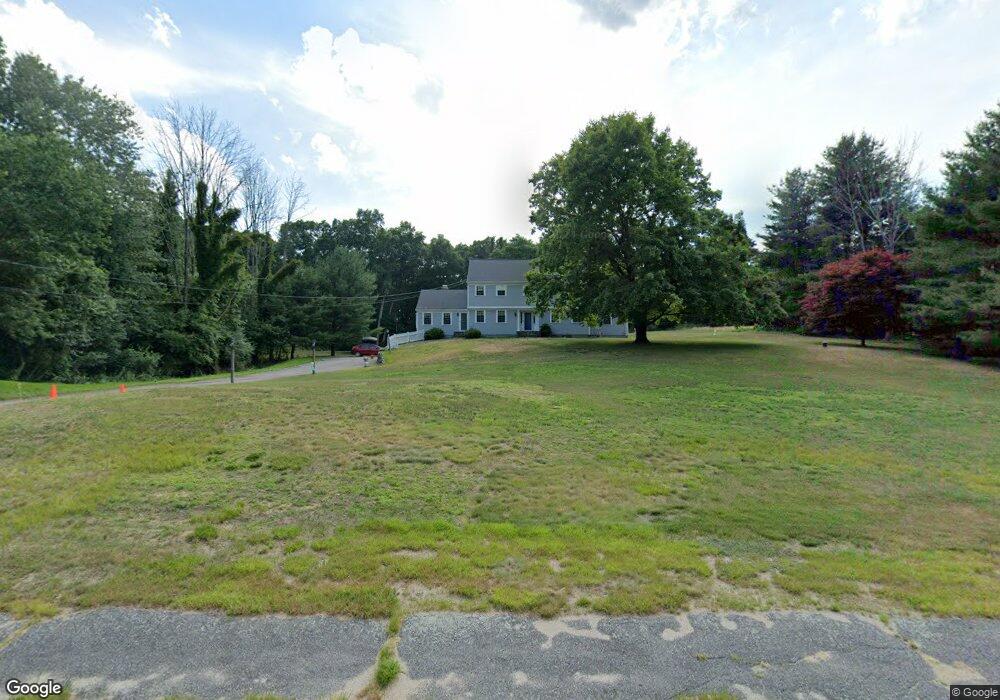
42 Oldfield Dr Sherborn, MA 01770
Estimated Value: $1,297,329 - $1,539,000
4
Beds
3
Baths
3,026
Sq Ft
$462/Sq Ft
Est. Value
About This Home
This home is located at 42 Oldfield Dr, Sherborn, MA 01770 and is currently estimated at $1,397,582, approximately $461 per square foot. 42 Oldfield Dr is a home located in Middlesex County with nearby schools including Pine Hill Elementary School, Dover-Sherborn Regional Middle School, and Dover-Sherborn Regional High School.
Ownership History
Date
Name
Owned For
Owner Type
Purchase Details
Closed on
Apr 4, 2011
Sold by
Donnellan Barbara J and Saletan Timothy L
Bought by
Paton Stephen G and Paton Karen S
Current Estimated Value
Home Financials for this Owner
Home Financials are based on the most recent Mortgage that was taken out on this home.
Original Mortgage
$375,000
Outstanding Balance
$261,599
Interest Rate
5.04%
Mortgage Type
Purchase Money Mortgage
Estimated Equity
$1,135,983
Purchase Details
Closed on
May 29, 1991
Sold by
Barlow Engineering
Bought by
Donnellan Barbara J and Saletan Timothy L
Purchase Details
Closed on
Dec 30, 1988
Sold by
Barlow Norman M
Bought by
Barlow Engineering
Create a Home Valuation Report for This Property
The Home Valuation Report is an in-depth analysis detailing your home's value as well as a comparison with similar homes in the area
Home Values in the Area
Average Home Value in this Area
Purchase History
| Date | Buyer | Sale Price | Title Company |
|---|---|---|---|
| Paton Stephen G | $688,000 | -- | |
| Donnellan Barbara J | $340,000 | -- | |
| Barlow Engineering | $465,000 | -- |
Source: Public Records
Mortgage History
| Date | Status | Borrower | Loan Amount |
|---|---|---|---|
| Open | Barlow Engineering | $50,000 | |
| Open | Paton Stephen G | $375,000 | |
| Previous Owner | Barlow Engineering | $455,000 | |
| Previous Owner | Barlow Engineering | $25,000 |
Source: Public Records
Tax History Compared to Growth
Tax History
| Year | Tax Paid | Tax Assessment Tax Assessment Total Assessment is a certain percentage of the fair market value that is determined by local assessors to be the total taxable value of land and additions on the property. | Land | Improvement |
|---|---|---|---|---|
| 2025 | $18,543 | $1,118,400 | $470,700 | $647,700 |
| 2024 | $17,223 | $1,016,100 | $462,000 | $554,100 |
| 2023 | $15,645 | $868,700 | $462,000 | $406,700 |
| 2022 | $15,096 | $793,300 | $450,400 | $342,900 |
| 2021 | $4,577 | $765,200 | $450,400 | $314,800 |
| 2020 | $14,891 | $765,200 | $450,400 | $314,800 |
| 2019 | $14,929 | $760,900 | $450,400 | $310,500 |
| 2018 | $14,475 | $750,000 | $450,400 | $299,600 |
| 2017 | $3,949 | $710,100 | $444,600 | $265,500 |
| 2016 | $13,877 | $674,600 | $415,800 | $258,800 |
| 2015 | $13,612 | $669,900 | $404,200 | $265,700 |
| 2014 | $13,146 | $646,300 | $392,700 | $253,600 |
Source: Public Records
Map
Nearby Homes
- 18 Wildwood Dr
- 81 Brush Hill Rd
- 4 Green Ln
- 1 Adams Rd
- 9 Adams Rd
- 2 Adams Rd Unit 2
- 11 Weld St Unit 37
- 151 Mohawk Path
- 6 Brook St
- 7 Weld St Unit 50
- 7 Weld St Unit 35
- 2 Universal St Unit A
- 15 Bates Rd
- 84 E Bluff Rd
- 306 Trailside Way
- 72 Pond St
- 67 Spyglass Hill Dr
- 2 Surrey Ln
- 105 N Main St
- 45 Half Crown Cir
- 46 Oldfield Dr
- 34 Oldfield Dr
- 24 Oldfield Dr
- 41 Oldfield Dr
- 12 Oldfield Dr
- 37 Oldfield Dr
- 45 Oldfield Dr
- 50 Oldfield Dr
- 4 Mcgregor Dr
- 49 Oldfield Dr
- 31 Oldfield Dr
- 61 Harrington Ridge Rd
- 53 Oldfield Dr
- 57 Harrington Ridge Rd
- 77 Harrington Ridge Rd
- 58 Oldfield Dr
- 27 Oldfield Dr
- 65 Harrington Ridge Rd
- 5 Mcgregor Dr
- 11 Oldfield Dr