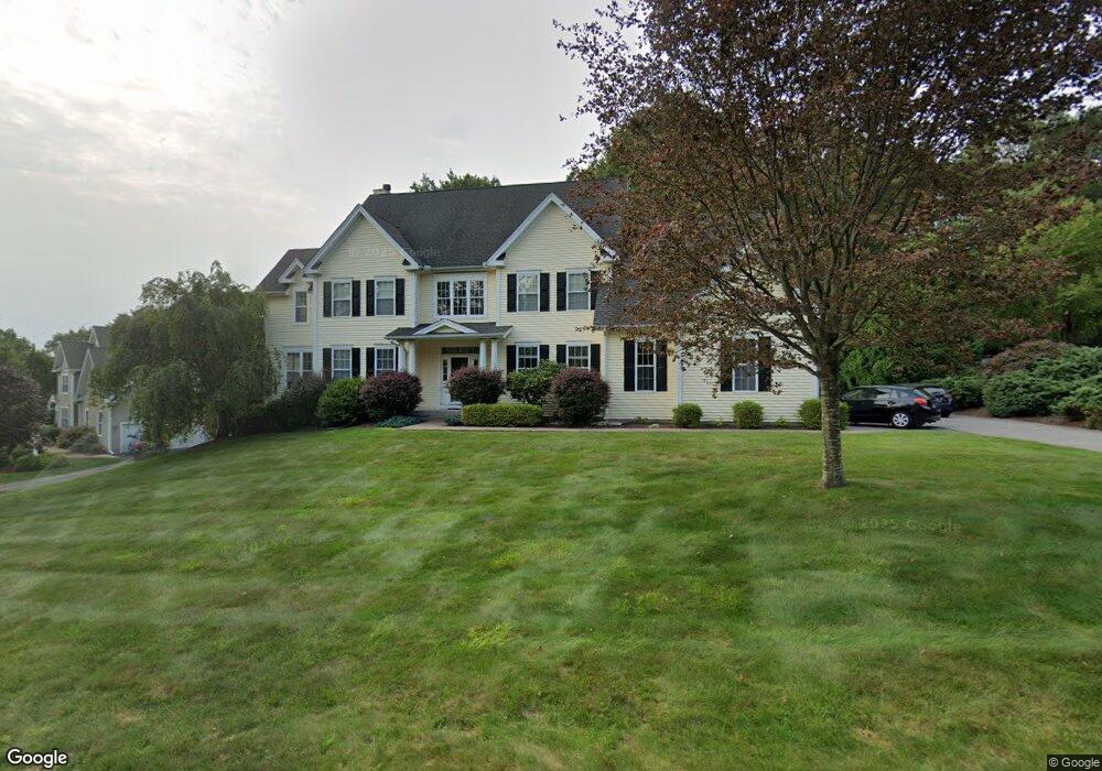
42 Queens Peak Canton, CT 06019
Estimated Value: $857,000 - $899,086
4
Beds
3
Baths
3,521
Sq Ft
$250/Sq Ft
Est. Value
About This Home
This home is located at 42 Queens Peak, Canton, CT 06019 and is currently estimated at $881,772, approximately $250 per square foot. 42 Queens Peak is a home located in Hartford County with nearby schools including Cherry Brook Primary School, Canton Intermediate School, and Canton Middle School.
Ownership History
Date
Name
Owned For
Owner Type
Purchase Details
Closed on
Mar 26, 2024
Sold by
Lacombe Nathan P and Lacombe Charlotte N
Bought by
Nathan P Lacombe T P and Nathan Lacombe
Current Estimated Value
Purchase Details
Closed on
May 27, 2003
Sold by
Baker Residential and Limited Partership
Bought by
Lacombe Nathan P and Lacombe Charlotte N
Create a Home Valuation Report for This Property
The Home Valuation Report is an in-depth analysis detailing your home's value as well as a comparison with similar homes in the area
Home Values in the Area
Average Home Value in this Area
Purchase History
| Date | Buyer | Sale Price | Title Company |
|---|---|---|---|
| Nathan P Lacombe T P | -- | None Available | |
| Nathan P Lacombe T P | -- | None Available | |
| Lacombe Nathan P | $461,180 | -- | |
| Lacombe Nathan P | $461,180 | -- |
Source: Public Records
Mortgage History
| Date | Status | Borrower | Loan Amount |
|---|---|---|---|
| Previous Owner | Lacombe Nathan P | $337,500 | |
| Previous Owner | Lacombe Nathan P | $337,000 | |
| Previous Owner | Lacombe Nathan P | $342,000 | |
| Previous Owner | Lacombe Nathan P | $125,000 |
Source: Public Records
Tax History
| Year | Tax Paid | Tax Assessment Tax Assessment Total Assessment is a certain percentage of the fair market value that is determined by local assessors to be the total taxable value of land and additions on the property. | Land | Improvement |
|---|---|---|---|---|
| 2025 | $15,853 | $473,220 | $93,140 | $380,080 |
| 2024 | $16,160 | $473,220 | $93,140 | $380,080 |
| 2023 | $12,897 | $364,620 | $98,100 | $266,520 |
| 2022 | $12,284 | $364,620 | $98,100 | $266,520 |
| 2021 | $12,113 | $364,620 | $98,100 | $266,520 |
| 2020 | $11,883 | $364,620 | $98,100 | $266,520 |
| 2019 | $11,679 | $364,620 | $98,100 | $266,520 |
| 2018 | $12,468 | $406,130 | $105,000 | $301,130 |
| 2017 | $12,383 | $406,130 | $105,000 | $301,130 |
| 2016 | $12,086 | $406,130 | $105,000 | $301,130 |
| 2015 | $11,623 | $398,170 | $105,000 | $293,170 |
| 2014 | $11,372 | $398,170 | $105,000 | $293,170 |
Source: Public Records
Map
Nearby Homes
- 48 Weatherstone
- 58 Weatherstone
- 29 Lovely St
- 61 Weatherstone
- 12 Craigemore Cir
- 3 Clearwater Ct
- 102 Cold Spring Rd
- 30 Cliff Dr
- 40 E Hill Rd
- 49 Applegate Ln Unit 49
- 26 Forest Ln
- 706 Timber Ln Unit 706
- 138 Northington Dr
- 64 Bridge St
- 51 Westland Rd
- 7 Woodmont Rd
- 4 Tanglewood Dr
- 370A W Mountain Rd
- 14 Brookview Cir
- 187 W Avon Rd
- 36 Queens Peak
- 48 Queens Peak
- 226 Kingswood Dr
- 60 Queens Peak
- 45 Queens Peak
- 30 Queens Peak
- 54 Queens Peak
- 234 Kingswood Dr
- 39 Queens Peak
- 57 Queens Peak
- 31 Queens Peak
- 51 Queens Peak
- 218 Kingswood Dr
- 9 Ellsworth Ln
- 225 Kingswood Dr
- 246 Kingswood Dr
- 24 Queens Peak
- 233 Kingswood Dr
- 23 Queens Peak
- 210 Kingswood Dr
Your Personal Tour Guide
Ask me questions while you tour the home.