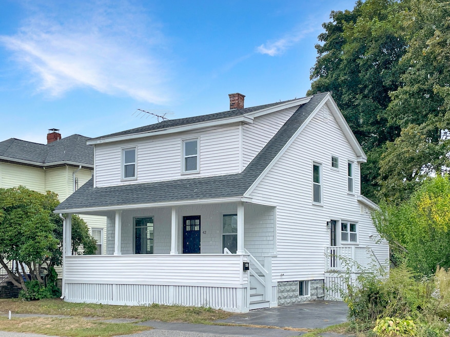

42 Reynolds St South Portland, ME 04106
Pleasantdale NeighborhoodEstimated payment $3,138/month
Highlights
- Public Beach
- Wood Flooring
- Main Floor Bedroom
- Property is near public transit
- New Englander Architecture
- Granite Countertops
About This Home
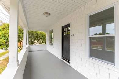
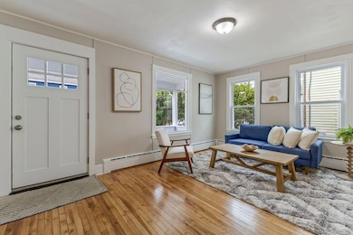
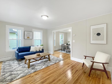
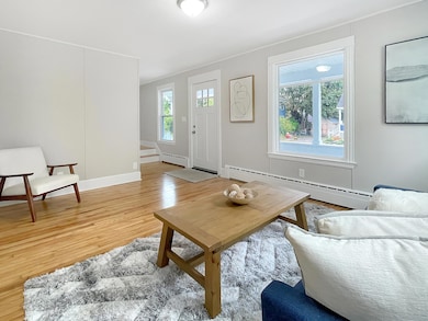
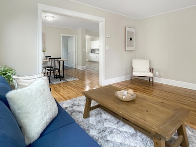
Great in-town location!!! This charming four bedroom, 2 bath New Englander is truly ''move in ready'', offering a flexible floor plan with the option of a primary bedroom on either the first or second level. You'll be warmly greeted by the welcoming porch, then enter into a spacious living room with gleaming hardwood floors, gracefully flowing into the dining room and updated 3/4 bath. The spacious kitchen boasts extensive windows, new stainless steel appliances, granite countertops, a large pantry and convenient laundry area. The second floor offers three generous bedrooms and another updated family bath. This home has been beautifully updated including new flooring throughout, tastefully painted interior and new windows. The full, unspoiled basement offers expansion potential as well as plenty of storage. Convenient to the town center, schools, shopping and beaches. Call today for an appointment to view this amazing home! Broker interest.
Home Details
Home Type
- Single Family
Est. Annual Taxes
- $4,934
Year Built
- Built in 1922
Lot Details
- 4,792 Sq Ft Lot
- Public Beach
- Level Lot
- Property is zoned PL
Home Design
- New Englander Architecture
- Concrete Foundation
- Block Foundation
- Wood Frame Construction
- Shingle Roof
- Vinyl Siding
- Concrete Perimeter Foundation
Interior Spaces
- 1,742 Sq Ft Home
- Multi-Level Property
- Living Room
- Dining Room
- Laundry on main level
Kitchen
- Electric Range
- Dishwasher
- Granite Countertops
Flooring
- Wood
- Carpet
- Luxury Vinyl Tile
Bedrooms and Bathrooms
- 4 Bedrooms
- Main Floor Bedroom
- 2 Full Bathrooms
- Bathtub
Unfinished Basement
- Basement Fills Entire Space Under The House
- Interior Basement Entry
- Sump Pump
Parking
- Driveway
- Paved Parking
Outdoor Features
- Porch
Location
- Property is near public transit
- Property is near a golf course
- City Lot
Utilities
- No Cooling
- Heating System Uses Oil
- Baseboard Heating
- Hot Water Heating System
- Natural Gas Not Available
- Electric Water Heater
Community Details
- No Home Owners Association
Listing and Financial Details
- Tax Lot 013
- Assessor Parcel Number SPOR-000025-000000-000013
Map
Home Values in the Area
Average Home Value in this Area
Tax History
| Year | Tax Paid | Tax Assessment Tax Assessment Total Assessment is a certain percentage of the fair market value that is determined by local assessors to be the total taxable value of land and additions on the property. | Land | Improvement |
|---|---|---|---|---|
| 2024 | $4,934 | $373,800 | $146,600 | $227,200 |
| 2023 | $4,184 | $295,900 | $96,800 | $199,100 |
| 2022 | $3,990 | $256,400 | $77,400 | $179,000 |
| 2021 | $3,313 | $256,400 | $77,400 | $179,000 |
| 2020 | $3,124 | $189,200 | $67,000 | $122,200 |
| 2019 | $3,148 | $189,200 | $67,000 | $122,200 |
| 2018 | $3,060 | $194,800 | $67,000 | $127,800 |
| 2017 | $3,506 | $194,800 | $67,000 | $127,800 |
| 2016 | $3,448 | $194,800 | $67,000 | $127,800 |
| 2015 | $3,390 | $194,800 | $67,000 | $127,800 |
| 2014 | $3,057 | $194,800 | $67,000 | $127,800 |
| 2013 | -- | $194,800 | $67,000 | $127,800 |
Property History
| Date | Event | Price | List to Sale | Price per Sq Ft |
|---|---|---|---|---|
| 11/10/2025 11/10/25 | Pending | -- | -- | -- |
| 10/29/2025 10/29/25 | Price Changed | $519,900 | -1.0% | $298 / Sq Ft |
| 09/24/2025 09/24/25 | For Sale | $525,000 | -- | $301 / Sq Ft |
Purchase History
| Date | Type | Sale Price | Title Company |
|---|---|---|---|
| Personal Reps Deed | $310,800 | None Available | |
| Personal Reps Deed | $310,800 | None Available |
Mortgage History
| Date | Status | Loan Amount | Loan Type |
|---|---|---|---|
| Open | $383,980 | Purchase Money Mortgage | |
| Closed | $383,980 | Purchase Money Mortgage |
Source: Maine Listings
MLS Number: 1638793
APN: SPOR-000025-000000-000013
Disclaimer: Certain information contained herein is derived from information provided by parties other than Homes.com. All information provided is deemed reliable, but is not guaranteed to be accurate and should be independently verified.
![]() Listing data is derived in whole or in part from Maine Real Estate Information System, Inc. (d/b/a Maine Listings) and is for consumers' personal, noncommercial use only. Dimensions are approximate and not guaranteed. All data should be independently verified.
Listing data is derived in whole or in part from Maine Real Estate Information System, Inc. (d/b/a Maine Listings) and is for consumers' personal, noncommercial use only. Dimensions are approximate and not guaranteed. All data should be independently verified.
© 2025 Maine Real Estate Information System, Inc. All Rights Reserved. Equal Housing Opportunity.
Homes.com, LLC, 17600 Laguna Canyon Rd Irvine, CA 92618 (888)-952-6393
![]()
- 34 Minott St Unit B7
- 66 Evans St Unit 3
- 11 Chestnut St
- 404 Lincoln St
- 39 Morse St
- 35 Palmer St
- 7 Allen Rd
- 42 Buchanan St
- 1309 Broadway
- 1 Karynel Dr Unit 1
- 17 b Peary Terrace
- 141 Mckinley St
- 56 Peary Terrace
- 11 Jackson St
- 311 Ocean St
- 338 Ocean St
- 360 Ocean St
- 18 Plover Way Unit 29
- 24 Plover Way Unit 34
- 17 Plover Way Unit 27
