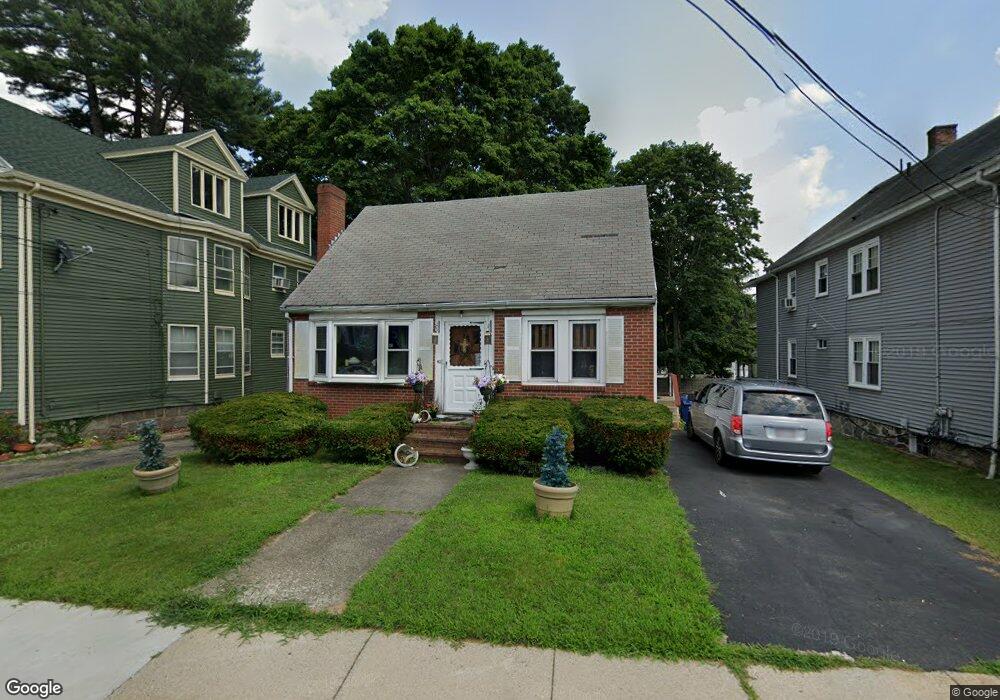
42 Rugby Rd Mattapan, MA 02126
Southern Mattapan NeighborhoodEstimated Value: $551,000 - $615,000
4
Beds
1
Bath
1,281
Sq Ft
$455/Sq Ft
Est. Value
About This Home
This home is located at 42 Rugby Rd, Mattapan, MA 02126 and is currently estimated at $583,388, approximately $455 per square foot. 42 Rugby Rd is a home located in Suffolk County with nearby schools including KIPP Academy Boston Charter School, Boston Preparatory Charter Public School, and Berea Seventh-day Adventist Academy.
Ownership History
Date
Name
Owned For
Owner Type
Purchase Details
Closed on
Mar 30, 1990
Sold by
Fenton Hensey A
Bought by
Hurst David
Current Estimated Value
Home Financials for this Owner
Home Financials are based on the most recent Mortgage that was taken out on this home.
Original Mortgage
$139,500
Interest Rate
9.96%
Mortgage Type
Purchase Money Mortgage
Create a Home Valuation Report for This Property
The Home Valuation Report is an in-depth analysis detailing your home's value as well as a comparison with similar homes in the area
Home Values in the Area
Average Home Value in this Area
Purchase History
| Date | Buyer | Sale Price | Title Company |
|---|---|---|---|
| Hurst David | $155,000 | -- |
Source: Public Records
Mortgage History
| Date | Status | Borrower | Loan Amount |
|---|---|---|---|
| Open | Hurst David | $159,700 | |
| Closed | Hurst David | $139,500 | |
| Previous Owner | Hurst David | $20,000 |
Source: Public Records
Tax History Compared to Growth
Tax History
| Year | Tax Paid | Tax Assessment Tax Assessment Total Assessment is a certain percentage of the fair market value that is determined by local assessors to be the total taxable value of land and additions on the property. | Land | Improvement |
|---|---|---|---|---|
| 2025 | $5,481 | $473,300 | $164,000 | $309,300 |
| 2024 | $4,989 | $457,700 | $160,500 | $297,200 |
| 2023 | $4,682 | $435,900 | $152,900 | $283,000 |
| 2022 | $4,390 | $403,500 | $141,500 | $262,000 |
| 2021 | $3,984 | $373,400 | $134,800 | $238,600 |
| 2020 | $3,405 | $322,400 | $131,800 | $190,600 |
| 2019 | $3,255 | $308,800 | $100,000 | $208,800 |
| 2018 | $3,023 | $288,500 | $100,000 | $188,500 |
| 2017 | $2,812 | $265,500 | $100,000 | $165,500 |
| 2016 | $2,655 | $241,400 | $100,000 | $141,400 |
| 2015 | $2,556 | $211,100 | $99,000 | $112,100 |
| 2014 | $2,435 | $193,600 | $99,000 | $94,600 |
Source: Public Records
Map
Nearby Homes
- 839-843 Cummins Hwy
- 34 Ridlon Rd
- 231 Itasca St
- 770 Cummins Hwy Unit 1
- 770 Cummins Hwy Unit 22
- 10 Brockton St
- 90 Hollingsworth St
- 265 Hebron St
- 179 Hebron St
- 23 Caton St
- 7 Winborough St
- 0 Tina Ave
- 25 Alpine St Unit 7
- 95 Woodhaven St
- 48-50 Rockdale St
- 645 River St
- 72 Livermore St
- 100 Itasca St
- 20 Massasoit St
- 20 Monterey Ave
- 38 Rugby Rd
- 44 Rugby Rd Unit 46
- 34 Rugby Rd
- 131 Greenfield Rd
- 37 Rockingham Rd
- 35 Rockingham Rd
- 30 Rugby Rd
- 149 Greenfield Rd
- 125 Greenfield Rd
- 31 Rugby Rd
- 31 Rockingham Rd
- 28 Rugby Rd
- 146 Greenfield Rd
- 143 Blake St
- 29 Rugby Rd
- 20 Rugby Rd Unit 22
- 157 Greenfield Rd
- 132 Greenfield Rd
- 27 Rockingham Rd
- 150 Greenfield Rd