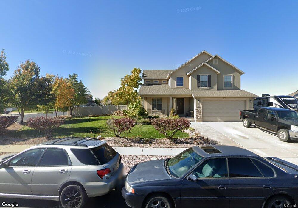
42 S 1650 E Unit SR25F Spanish Fork, UT 84660
Estimated Value: $589,000 - $675,000
4
Beds
3
Baths
3,187
Sq Ft
$197/Sq Ft
Est. Value
About This Home
This home is located at 42 S 1650 E Unit SR25F, Spanish Fork, UT 84660 and is currently estimated at $629,403, approximately $197 per square foot. 42 S 1650 E Unit SR25F is a home located in Utah County with nearby schools including Sierra Bonita Elementary School, Mapleton Junior High School, and Maple Mountain High School.
Ownership History
Date
Name
Owned For
Owner Type
Purchase Details
Closed on
Oct 27, 2009
Sold by
Homes By Harmony Inc
Bought by
Orr Jonathan David and Ivers Orr Kayelynn
Current Estimated Value
Home Financials for this Owner
Home Financials are based on the most recent Mortgage that was taken out on this home.
Original Mortgage
$213,318
Outstanding Balance
$139,288
Interest Rate
5%
Mortgage Type
FHA
Estimated Equity
$490,115
Purchase Details
Closed on
Sep 3, 2009
Sold by
Sunny Ridge Plat F Llc
Bought by
Homes By Harmony Inc
Home Financials for this Owner
Home Financials are based on the most recent Mortgage that was taken out on this home.
Original Mortgage
$213,318
Outstanding Balance
$139,288
Interest Rate
5%
Mortgage Type
FHA
Estimated Equity
$490,115
Purchase Details
Closed on
Aug 20, 2008
Sold by
Jon Fullmer Construction Inc
Bought by
Far West Bank
Create a Home Valuation Report for This Property
The Home Valuation Report is an in-depth analysis detailing your home's value as well as a comparison with similar homes in the area
Home Values in the Area
Average Home Value in this Area
Purchase History
| Date | Buyer | Sale Price | Title Company |
|---|---|---|---|
| Orr Jonathan David | -- | Provo Land Title Company | |
| Homes By Harmony Inc | -- | Provo Land Title Company | |
| Far West Bank | $2,530,000 | None Available |
Source: Public Records
Mortgage History
| Date | Status | Borrower | Loan Amount |
|---|---|---|---|
| Open | Orr Jonathan David | $213,318 |
Source: Public Records
Tax History
| Year | Tax Paid | Tax Assessment Tax Assessment Total Assessment is a certain percentage of the fair market value that is determined by local assessors to be the total taxable value of land and additions on the property. | Land | Improvement |
|---|---|---|---|---|
| 2025 | $2,745 | $310,310 | -- | -- |
| 2024 | $2,745 | $282,975 | $0 | $0 |
| 2023 | $2,822 | $291,225 | $0 | $0 |
| 2022 | $3,046 | $308,275 | $0 | $0 |
| 2021 | $2,574 | $416,800 | $148,100 | $268,700 |
| 2020 | $2,393 | $376,700 | $134,600 | $242,100 |
| 2019 | $2,099 | $347,600 | $126,100 | $221,500 |
| 2018 | $2,065 | $330,500 | $115,300 | $215,200 |
| 2017 | $1,994 | $171,600 | $0 | $0 |
| 2016 | $1,829 | $155,320 | $0 | $0 |
| 2015 | $1,851 | $155,320 | $0 | $0 |
| 2014 | $1,755 | $147,730 | $0 | $0 |
Source: Public Records
Map
Nearby Homes
- 1455 E 100 S
- 1563 E Mountain View Dr
- 1815 E 160 S
- 1658 Dover Dr
- 1005 E 260 N Unit 20
- 1238 E 100 S
- 1884 E 280 S
- 53 S 2000 E
- 136 N 1120 E
- 325 S 1230 E
- 1330 E 410 S
- 2672 E 360 N Unit MRVL09
- 1025 E 360 N Unit 5
- 1022 E 360 N Unit 27
- 991 E 360 N Unit 8
- 2117 E 130 N Unit 59
- 2137 E 200 N Unit MSF53
- 2138 E 200 N Unit MSF54
- 2163 E 200 N Unit MSF52
- 1495 E 400 N
Your Personal Tour Guide
Ask me questions while you tour the home.