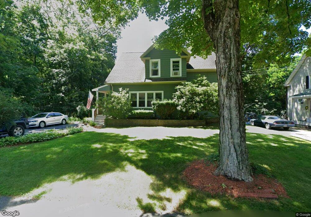
42 Sturdy St Norton, MA 02766
Estimated Value: $534,324 - $645,000
3
Beds
2
Baths
1,774
Sq Ft
$328/Sq Ft
Est. Value
About This Home
This home is located at 42 Sturdy St, Norton, MA 02766 and is currently estimated at $582,081, approximately $328 per square foot. 42 Sturdy St is a home located in Bristol County with nearby schools including J.C. Solmonese Elementary School, Henri A. Yelle Elementary School, and Norton Middle School.
Ownership History
Date
Name
Owned For
Owner Type
Purchase Details
Closed on
Jan 27, 2014
Sold by
Gomes Alfred D and Gomes Kristen E
Bought by
Gomes Melissa
Current Estimated Value
Purchase Details
Closed on
Feb 1, 1985
Bought by
Gomes Alfred D and Gomes Kristen E
Create a Home Valuation Report for This Property
The Home Valuation Report is an in-depth analysis detailing your home's value as well as a comparison with similar homes in the area
Home Values in the Area
Average Home Value in this Area
Purchase History
| Date | Buyer | Sale Price | Title Company |
|---|---|---|---|
| Gomes Melissa | -- | -- | |
| Gomes Alfred D | $68,000 | -- |
Source: Public Records
Mortgage History
| Date | Status | Borrower | Loan Amount |
|---|---|---|---|
| Previous Owner | Gomes Alfred D | $128,000 | |
| Previous Owner | Gomes Alfred D | $100,000 | |
| Previous Owner | Gomes Alfred D | $89,200 |
Source: Public Records
Tax History Compared to Growth
Tax History
| Year | Tax Paid | Tax Assessment Tax Assessment Total Assessment is a certain percentage of the fair market value that is determined by local assessors to be the total taxable value of land and additions on the property. | Land | Improvement |
|---|---|---|---|---|
| 2025 | $54 | $413,400 | $160,000 | $253,400 |
| 2024 | $5,100 | $393,800 | $152,300 | $241,500 |
| 2023 | $5,171 | $398,100 | $159,700 | $238,400 |
| 2022 | $5,008 | $351,200 | $145,100 | $206,100 |
| 2021 | $4,719 | $316,100 | $138,200 | $177,900 |
| 2020 | $4,544 | $307,000 | $134,200 | $172,800 |
| 2019 | $4,401 | $295,400 | $129,100 | $166,300 |
| 2018 | $4,274 | $281,900 | $129,100 | $152,800 |
| 2017 | $4,158 | $270,500 | $129,100 | $141,400 |
| 2016 | $4,026 | $257,900 | $129,100 | $128,800 |
| 2015 | $3,689 | $239,700 | $113,900 | $125,800 |
| 2014 | $3,511 | $228,400 | $108,500 | $119,900 |
Source: Public Records
Map
Nearby Homes
- 55 Sturdy St
- 53 Sturdy St
- 108 S Worcester St
- 16 Park Ln
- 145 S Worcester St
- 64 Ridgehill Rd
- 19 Precourt Ln
- 170 S Worcester St Unit 3
- 178 S Worcester St
- 180 Pike Ave
- 225 S Worcester St Unit 1
- 225 S Worcester St Unit 2
- 293 Pike Ave
- 4 Village Way Unit F
- 73 Butterworth Dr
- 19 Cherry Tree Ln
- 933 Pleasant St
- 366 & 0 Pike Ave
- 48 Dean St
- 730 Pike Ave