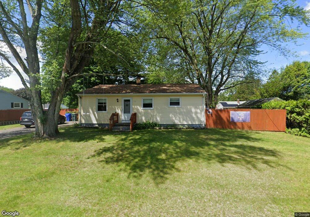
42 Talmadge Dr Springfield, MA 01118
Sixteen Acres NeighborhoodEstimated Value: $251,000 - $283,000
3
Beds
1
Bath
999
Sq Ft
$272/Sq Ft
Est. Value
About This Home
This home is located at 42 Talmadge Dr, Springfield, MA 01118 and is currently estimated at $272,066, approximately $272 per square foot. 42 Talmadge Dr is a home located in Hampden County with nearby schools including Arthur T Talmadge Elementary School, M Marcus Kiley Middle, and Springfield High School of Science and Technology.
Ownership History
Date
Name
Owned For
Owner Type
Purchase Details
Closed on
Jan 28, 2014
Sold by
Fiore James W
Bought by
Fiore James W
Current Estimated Value
Purchase Details
Closed on
Feb 10, 2011
Sold by
Nedham Robert
Bought by
Springfield City Of
Purchase Details
Closed on
Aug 2, 1988
Sold by
Maxwell Rachel F
Bought by
Nedham Robert
Create a Home Valuation Report for This Property
The Home Valuation Report is an in-depth analysis detailing your home's value as well as a comparison with similar homes in the area
Home Values in the Area
Average Home Value in this Area
Purchase History
| Date | Buyer | Sale Price | Title Company |
|---|---|---|---|
| Fiore James W | $103,425 | -- | |
| Springfield City Of | $3,173 | -- | |
| Nedham Robert | $3,000 | -- |
Source: Public Records
Tax History Compared to Growth
Tax History
| Year | Tax Paid | Tax Assessment Tax Assessment Total Assessment is a certain percentage of the fair market value that is determined by local assessors to be the total taxable value of land and additions on the property. | Land | Improvement |
|---|---|---|---|---|
| 2025 | $3,553 | $226,600 | $58,200 | $168,400 |
| 2024 | $3,291 | $204,900 | $58,200 | $146,700 |
| 2023 | $3,287 | $192,800 | $55,400 | $137,400 |
| 2022 | $2,836 | $150,700 | $55,400 | $95,300 |
| 2021 | $2,697 | $142,700 | $50,300 | $92,400 |
| 2020 | $2,760 | $141,300 | $50,300 | $91,000 |
| 2019 | $2,592 | $131,700 | $50,300 | $81,400 |
| 2018 | $2,497 | $126,900 | $50,300 | $76,600 |
| 2017 | $2,397 | $121,900 | $50,300 | $71,600 |
| 2016 | $2,402 | $122,200 | $50,300 | $71,900 |
| 2015 | $2,329 | $118,400 | $50,300 | $68,100 |
Source: Public Records
Map
Nearby Homes
- 86 Talmadge Dr
- 82 Louis Rd
- 54 Shady Brook Ln
- 17 Pebble Mill Rd
- 99 W Crystal Brook Dr
- 41 Hillside Dr
- 55 Allen St
- 41 Kerry Dr
- 43 Sunridge Dr
- 767 S Branch Pkwy
- 196 Sawmill Rd
- 331 Newhouse St
- 101 Regal St
- 5 Manor Ct Unit 5
- 19 Manor Ct Unit 19
- 125 Manor Ct Unit 125
- 290 Newton Rd
- 206 Treetop Ave
- 27 Regal St
- 392 Gifford St
- 32 Talmadge Dr
- 50 Talmadge Dr
- 41 Newhouse St
- 27 Newhouse St
- 45 Talmadge Dr
- 35 Talmadge Dr
- 60 Talmadge Dr
- 51 Newhouse St
- 53 Talmadge Dr
- 27 Talmadge Dr
- 34 Newhouse St
- 44 Newhouse St
- 1372 Allen St
- 68 Talmadge Dr
- 61 Newhouse St
- 63 Talmadge Dr
- 63 Talmadge Dr Unit 1
- 24 Newhouse St
- 52 Newhouse St
- 73 Talmadge Dr