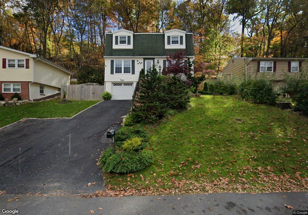
42 Vail Rd Landing, NJ 07850
Estimated Value: $435,800 - $532,000
--
Bed
--
Bath
1,600
Sq Ft
$296/Sq Ft
Est. Value
About This Home
This home is located at 42 Vail Rd, Landing, NJ 07850 and is currently estimated at $474,200, approximately $296 per square foot. 42 Vail Rd is a home located in Morris County with nearby schools including Eisenhower Middle School, Lincoln Roosevelt Elementary School, and Roxbury High School.
Ownership History
Date
Name
Owned For
Owner Type
Purchase Details
Closed on
Aug 21, 2002
Sold by
Mukhopadhyay Parthasaarathi
Bought by
Barrios Raymond and Barrios Aracelii
Current Estimated Value
Home Financials for this Owner
Home Financials are based on the most recent Mortgage that was taken out on this home.
Original Mortgage
$186,000
Outstanding Balance
$78,818
Interest Rate
6.57%
Estimated Equity
$395,382
Purchase Details
Closed on
Jan 7, 2000
Sold by
Vanderpool Edward W and Vanderpool Betsey
Bought by
Mukhopadhyay Parthasarathi and Mukhopadhyay Anindita
Purchase Details
Closed on
Mar 3, 1999
Sold by
Tedeschi John T and Tedeschi Debra
Bought by
Vanderpool Edward W
Home Financials for this Owner
Home Financials are based on the most recent Mortgage that was taken out on this home.
Original Mortgage
$153,886
Interest Rate
6.73%
Mortgage Type
FHA
Create a Home Valuation Report for This Property
The Home Valuation Report is an in-depth analysis detailing your home's value as well as a comparison with similar homes in the area
Home Values in the Area
Average Home Value in this Area
Purchase History
| Date | Buyer | Sale Price | Title Company |
|---|---|---|---|
| Barrios Raymond | $207,000 | -- | |
| Mukhopadhyay Parthasarathi | $162,500 | -- | |
| Vanderpool Edward W | $154,000 | Fidelity National Title Ins |
Source: Public Records
Mortgage History
| Date | Status | Borrower | Loan Amount |
|---|---|---|---|
| Open | Barrios Raymond | $186,000 | |
| Previous Owner | Vanderpool Edward W | $153,886 |
Source: Public Records
Tax History Compared to Growth
Tax History
| Year | Tax Paid | Tax Assessment Tax Assessment Total Assessment is a certain percentage of the fair market value that is determined by local assessors to be the total taxable value of land and additions on the property. | Land | Improvement |
|---|---|---|---|---|
| 2025 | $6,796 | $247,200 | $80,500 | $166,700 |
| 2024 | $6,689 | $247,200 | $80,500 | $166,700 |
| 2023 | $6,689 | $247,200 | $80,500 | $166,700 |
| 2022 | $6,511 | $247,200 | $80,500 | $166,700 |
| 2021 | $6,511 | $247,200 | $80,500 | $166,700 |
| 2020 | $6,286 | $239,100 | $80,500 | $158,600 |
| 2019 | $6,169 | $239,100 | $80,500 | $158,600 |
| 2018 | $6,646 | $154,200 | $49,500 | $104,700 |
| 2017 | $6,611 | $154,200 | $49,500 | $104,700 |
| 2016 | $6,481 | $154,200 | $49,500 | $104,700 |
| 2015 | $6,321 | $154,200 | $49,500 | $104,700 |
| 2014 | $6,220 | $154,200 | $49,500 | $104,700 |
Source: Public Records
Map
Nearby Homes
- 33 Ford Rd Unit 35
- 5 Zachary Dr
- 16 Esposito Ln
- 21 Laurie Rd
- 90 Salmon Rd
- 504 Ryerson Rd
- 512 Colver Rd
- Oakmont Grand Plan at Stone Water Village
- Roanoke Plan at Stone Water Village
- Powell Plan at Stone Water Village
- 2 Zachary Dr
- 505 Logan Dr
- 545 Rogers Dr
- 537 Dell Rd
- 137 Lakeside Blvd
- 181 Orben Dr
- 168 Ledge-Landing
- 547 Atlas Rd
- 649 Henmar Dr
- 627 E Vail Rd