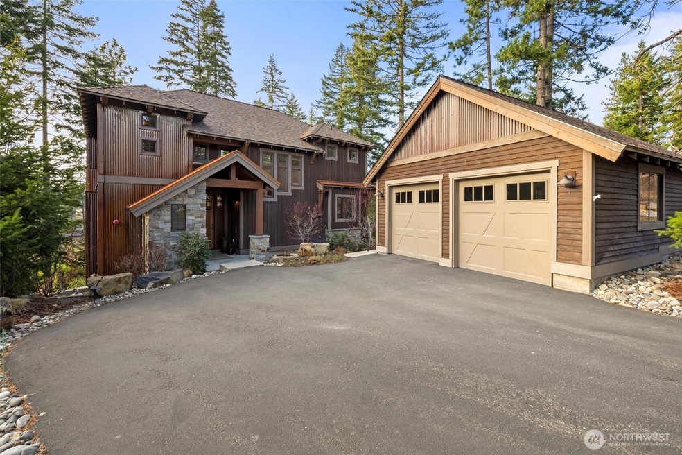
420 Black Nugget Ln Cle Elum, WA 98922
Estimated payment $9,265/month
Highlights
- Golf Course Community
- Granite Flooring
- Viking Appliances
- Golf Course View
- Craftsman Architecture
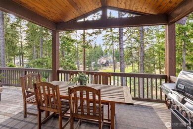
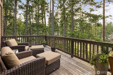
- Deck
About This Home
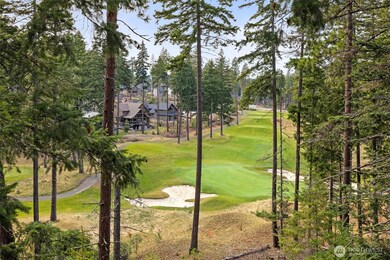
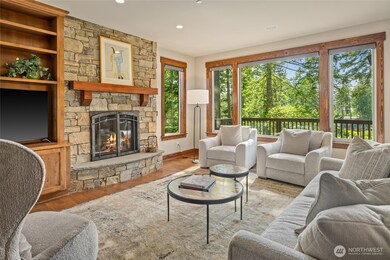
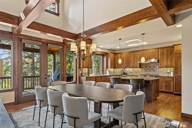
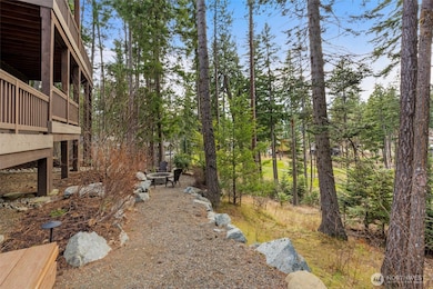
Tucked above the 15th Fairway in Suncadia’s ever-popular Black Nugget neighborhood, this Burnstead Custom Home offers golf-perch living, long western views, and space to gather. Quiet cul de sac location near parks, trails, Swiftwater Cellars, and Batista & Dawson Parks. Featuring: 4 bedrooms, lower-level rec room, and 3 levels of outdoor living with fire pit. Premium Viking, Sub-Zero, and Miele appliances elevate the kitchen. Rustic metal accents and a light-filled layout define the mountain craftsman style. Priced as one of the best values per square foot—your Suncadia escape awaits.
Source: Northwest Multiple Listing Service (NWMLS)
MLS#: 2389256
Home Details
Home Type
- Single Family
Est. Annual Taxes
- $10,347
Year Built
- Built in 2014
Lot Details
- 0.43 Acre Lot
- Open Space
- Cul-De-Sac
- Southwest Facing Home
- Brush Vegetation
- Sloped Lot
- Sprinkler System
- Wooded Lot
- Drought Tolerant Landscaping
- Property is in very good condition
HOA Fees
- $239 Monthly HOA Fees
Parking
- 2 Car Detached Garage
Property Views
- Golf Course
- Territorial
Home Design
- Craftsman Architecture
- Poured Concrete
- Composition Roof
- Metal Roof
- Wood Siding
- Stone Siding
- Metal Construction or Metal Frame
- Vinyl Construction Material
- Stone
Interior Spaces
- 3,466 Sq Ft Home
- 2-Story Property
- Ceiling Fan
- 2 Fireplaces
- Gas Fireplace
- Finished Basement
Kitchen
- Walk-In Pantry
- Double Oven
- Stove
- Microwave
- Dishwasher
- Viking Appliances
- Disposal
Flooring
- Wood
- Carpet
- Granite
- Ceramic Tile
Bedrooms and Bathrooms
- Walk-In Closet
- Bathroom on Main Level
Laundry
- Dryer
- Washer
Outdoor Features
- Deck
Utilities
- Forced Air Cooling System
- High Efficiency Heating System
- Private Water Source
- Water Heater
- High Speed Internet
Listing and Financial Details
- Tax Lot 1-10C-19
- Assessor Parcel Number 958350
Community Details
Overview
- Association fees include common area maintenance, road maintenance
- Edward Simpkins Association
- Secondary HOA Phone (509) 649-6273
- Built by Steve Burnstead Construction LLC
- Suncadia Subdivision
- The community has rules related to covenants, conditions, and restrictions
Recreation
- Golf Course Community
- Sport Court
- Community Playground
- Park
- Trails
Map
Home Values in the Area
Average Home Value in this Area
Tax History
| Year | Tax Paid | Tax Assessment Tax Assessment Total Assessment is a certain percentage of the fair market value that is determined by local assessors to be the total taxable value of land and additions on the property. | Land | Improvement |
|---|---|---|---|---|
| 2025 | $10,707 | $1,667,420 | $500,200 | $1,167,220 |
| 2023 | $10,707 | $1,619,470 | $503,600 | $1,115,870 |
| 2022 | $8,582 | $1,190,970 | $300,400 | $890,570 |
| 2021 | $8,162 | $1,079,910 | $223,900 | $856,010 |
| 2019 | $7,006 | $923,220 | $146,900 | $776,320 |
| 2018 | $5,668 | $707,870 | $99,750 | $608,120 |
| 2017 | $5,668 | $707,870 | $99,750 | $608,120 |
| 2016 | $5,686 | $707,870 | $99,750 | $608,120 |
| 2015 | $612 | $707,870 | $99,750 | $608,120 |
| 2013 | -- | $67,390 | $67,390 | $0 |
Property History
| Date | Event | Price | List to Sale | Price per Sq Ft |
|---|---|---|---|---|
| 10/25/2025 10/25/25 | Price Changed | $1,549,000 | -3.1% | $447 / Sq Ft |
| 07/11/2025 07/11/25 | Price Changed | $1,598,000 | -3.2% | $461 / Sq Ft |
| 06/07/2025 06/07/25 | For Sale | $1,650,000 | -- | $476 / Sq Ft |
Purchase History
| Date | Type | Sale Price | Title Company |
|---|---|---|---|
| Deed | -- | Chicago Title |
Source: Northwest Multiple Listing Service (NWMLS)
MLS Number: 2389256
APN: 958350
Disclaimer: Certain information contained herein is derived from information provided by parties other than Homes.com. All information provided is deemed reliable, but is not guaranteed to be accurate and should be independently verified.
![]() All data is obtained from various sources and may not have been verified by broker or MLS GRID. Supplied Open House Information is subject to change without notice. All information should be independently reviewed and verified for accuracy. Properties may or may not be listed by the office/agent presenting the information. Listing information is provided by the Northwest Multiple Listing Service (NWMLS). Property information is based on available data that may include MLS information, county records, and other sources. Listings marked with the 3 tree icon and provided by NWMLS. All properties are subject to prior sale or withdrawal. IDX information is provided exclusively for consumers’ personal noncommercial use, that it may not be used for any purpose other than to identify prospective properties consumers may be interested in purchasing, that the data is deemed reliable but is not guaranteed by MLS GRID. ©2025 NWMLS.
All data is obtained from various sources and may not have been verified by broker or MLS GRID. Supplied Open House Information is subject to change without notice. All information should be independently reviewed and verified for accuracy. Properties may or may not be listed by the office/agent presenting the information. Listing information is provided by the Northwest Multiple Listing Service (NWMLS). Property information is based on available data that may include MLS information, county records, and other sources. Listings marked with the 3 tree icon and provided by NWMLS. All properties are subject to prior sale or withdrawal. IDX information is provided exclusively for consumers’ personal noncommercial use, that it may not be used for any purpose other than to identify prospective properties consumers may be interested in purchasing, that the data is deemed reliable but is not guaranteed by MLS GRID. ©2025 NWMLS.
Based on information submitted to the MLS GRID
- 262 Black Nugget Ln
- 73 Sweet Shop Ln
- 130 Miners Camp Way
- 100 Black Nugget Ln
- 681 Maple Leaf Loop
- 301 Tipple Hill Loop
- 2101 Coal Mine Way
- 51 Lily Ct
- 221 Tipple Hill Loop
- 181 Cake Box Ln
- 282 Cake Box Ln
- 70 Thimbleberry Ct
- 61 Equinox Dr
- 221 Cake Box Ln
- 703 Equinox Dr
- 2040 Coal Mine Way
- 223 Cake Box Ln
- 460 Equinox Dr
- 51 Thimbleberry Ct
- 131 Big Hill Dr
