Estimated Value: $118,000 - $147,276
2
Beds
1
Bath
1,088
Sq Ft
$119/Sq Ft
Est. Value
About This Home
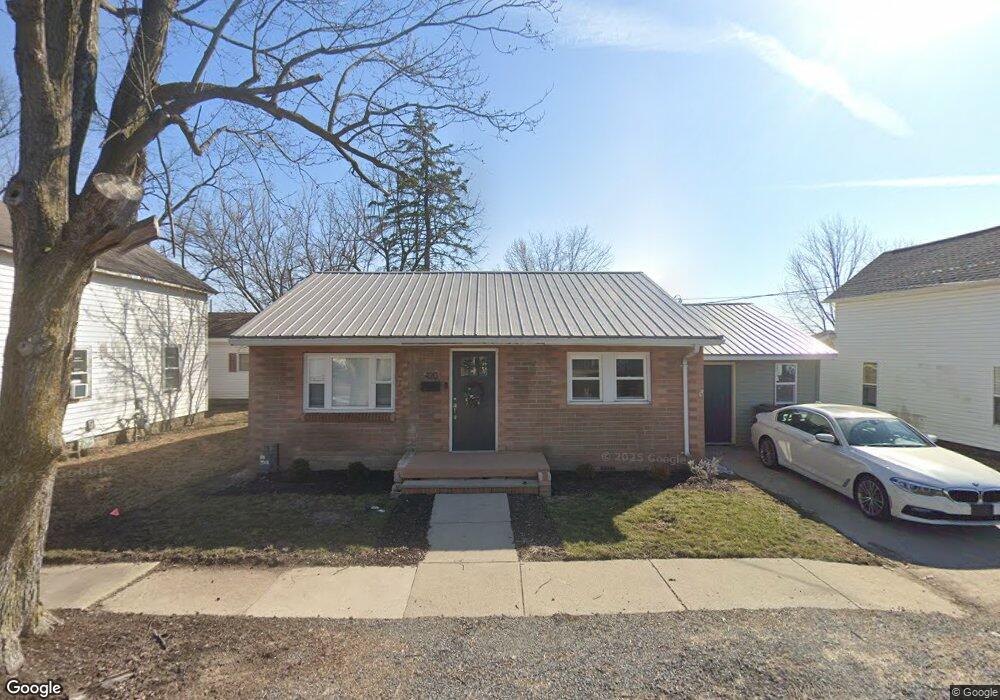
This home is located at 420 Liberty St, Ada, OH 45810 and is currently estimated at $129,569, approximately $119 per square foot. 420 Liberty St is a home located in Hardin County with nearby schools including Ada Elementary School and Ada High School.
Ownership History
Date
Name
Owned For
Owner Type
Purchase Details
Closed on
Dec 30, 2024
Sold by
Rowe Lucas and Rowe Kiley
Bought by
Rayle Cayden T and Bitters Lexi
Current Estimated Value
Home Financials for this Owner
Home Financials are based on the most recent Mortgage that was taken out on this home.
Original Mortgage
$135,800
Outstanding Balance
$134,852
Interest Rate
6.78%
Mortgage Type
New Conventional
Estimated Equity
-$5,283
Purchase Details
Closed on
Dec 21, 2021
Sold by
Allen Mark and Allen Kerrie Lynn
Bought by
Rowe Lucas and Rowe Kelly
Purchase Details
Closed on
Apr 8, 1999
Bought by
Allen Mark and Kerrie Lynn
Purchase Details
Closed on
Mar 5, 1997
Bought by
Hull Gary A and Hull Cassandra
Purchase Details
Closed on
Dec 22, 1995
Bought by
Clinger Wanda
Purchase Details
Closed on
Aug 29, 1995
Bought by
Clinger Wanda
Purchase Details
Closed on
Nov 6, 1987
Create a Home Valuation Report for This Property
The Home Valuation Report is an in-depth analysis detailing your home's value as well as a comparison with similar homes in the area
Home Values in the Area
Average Home Value in this Area
Purchase History
| Date | Buyer | Sale Price | Title Company |
|---|---|---|---|
| Rayle Cayden T | $140,000 | None Listed On Document | |
| Rayle Cayden T | $140,000 | None Listed On Document | |
| Rowe Lucas | $31,000 | None Available | |
| Allen Mark | $45,000 | -- | |
| Hull Gary A | $40,000 | -- | |
| Clinger Wanda | -- | -- | |
| Clinger Wanda | -- | -- | |
| -- | -- | -- |
Source: Public Records
Mortgage History
| Date | Status | Borrower | Loan Amount |
|---|---|---|---|
| Open | Rayle Cayden T | $135,800 | |
| Closed | Rayle Cayden T | $135,800 |
Source: Public Records
Tax History Compared to Growth
Tax History
| Year | Tax Paid | Tax Assessment Tax Assessment Total Assessment is a certain percentage of the fair market value that is determined by local assessors to be the total taxable value of land and additions on the property. | Land | Improvement |
|---|---|---|---|---|
| 2024 | $1,115 | $27,950 | $2,280 | $25,670 |
| 2023 | $1,111 | $27,950 | $2,280 | $25,670 |
| 2022 | $1,120 | $24,530 | $2,210 | $22,320 |
| 2021 | $1,231 | $24,530 | $2,210 | $22,320 |
| 2020 | $1,246 | $24,530 | $2,210 | $22,320 |
| 2019 | $1,116 | $22,170 | $2,100 | $20,070 |
| 2018 | $1,067 | $22,170 | $2,100 | $20,070 |
| 2017 | $989 | $22,170 | $2,100 | $20,070 |
| 2016 | $934 | $20,850 | $2,030 | $18,820 |
| 2015 | $887 | $20,850 | $2,030 | $18,820 |
| 2014 | $911 | $20,850 | $2,030 | $18,820 |
| 2013 | $1,008 | $21,960 | $2,030 | $19,930 |
Source: Public Records
Map
Nearby Homes
- 442 Edwards St
- 444 Edwards St Unit A, B
- 444 Edwards St Unit 2
- 212 N Simon St
- 211 S Main St
- 118 W Buckeye Ave
- 210 N Gilbert St
- 308-310 S Simon St
- 211 W Buckeye Ave Unit 211 1/2
- 629 N Main St
- 128 W North Ave
- 314 E University Ave
- 301 S Main St
- 710 S Main St
- 4071 Township Road 35
- 2864 Ohio 309
- 3931 County Road 80
- 3769 County Road 304
- 900 N Front St
- 22694 County Road 12
- 416 Liberty St
- 417 Liberty St
- 425 Liberty St
- 0 Liberty St Unit H137464
- 0 Liberty St
- 430 Liberty St
- 427 Liberty St Unit 429
- 409 Liberty St
- 410 Liberty St
- 408 Liberty St
- 407 Liberty St
- 436 Liberty St
- 402 Liberty St
- 435 Liberty St
- 416 E Montford Ave
- 416 Edwards St
- 428 Edwards St
- 319 Liberty St
- 501 Nliberty St