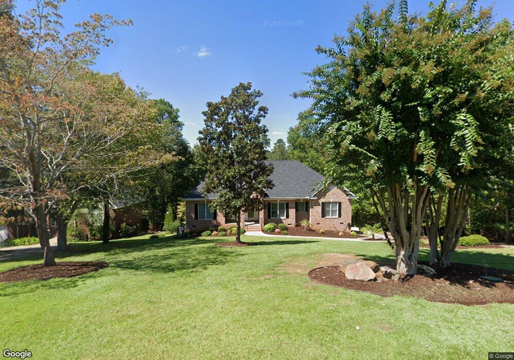
420 Lookover Pointe Dr Chapin, SC 29036
Estimated Value: $787,116 - $900,000
4
Beds
3
Baths
3,272
Sq Ft
$259/Sq Ft
Est. Value
About This Home
This home is located at 420 Lookover Pointe Dr, Chapin, SC 29036 and is currently estimated at $846,029, approximately $258 per square foot. 420 Lookover Pointe Dr is a home located in Lexington County with nearby schools including Chapin Elementary School, Chapin Intermediate, and Chapin High School.
Ownership History
Date
Name
Owned For
Owner Type
Purchase Details
Closed on
Jul 29, 2021
Sold by
Unangst Samuel J and Samuel J Unangst Revocable Tru
Bought by
Leslie Dale R and Leslie Juliana
Current Estimated Value
Home Financials for this Owner
Home Financials are based on the most recent Mortgage that was taken out on this home.
Original Mortgage
$429,650
Outstanding Balance
$390,860
Interest Rate
2.93%
Mortgage Type
New Conventional
Estimated Equity
$455,169
Purchase Details
Closed on
Feb 1, 2019
Sold by
Unangst Samuel J and Delzell Gail E
Bought by
Unangst Samuel J and The Samuel J Unangst Revocable
Purchase Details
Closed on
Feb 25, 2004
Sold by
Mcleod Develop Llc
Bought by
Hoy Johnny R
Purchase Details
Closed on
Feb 24, 2004
Sold by
Byrd Ron C
Bought by
Unangst Sam J
Create a Home Valuation Report for This Property
The Home Valuation Report is an in-depth analysis detailing your home's value as well as a comparison with similar homes in the area
Home Values in the Area
Average Home Value in this Area
Purchase History
| Date | Buyer | Sale Price | Title Company |
|---|---|---|---|
| Leslie Dale R | $661,000 | None Available | |
| Unangst Samuel J | -- | None Available | |
| Hoy Johnny R | $20,000 | -- | |
| Unangst Sam J | $402,000 | -- |
Source: Public Records
Mortgage History
| Date | Status | Borrower | Loan Amount |
|---|---|---|---|
| Open | Leslie Dale R | $429,650 |
Source: Public Records
Tax History
| Year | Tax Paid | Tax Assessment Tax Assessment Total Assessment is a certain percentage of the fair market value that is determined by local assessors to be the total taxable value of land and additions on the property. | Land | Improvement |
|---|---|---|---|---|
| 2024 | $3,808 | $26,440 | $4,800 | $21,640 |
| 2023 | $3,654 | $26,440 | $4,800 | $21,640 |
| 2022 | $4,082 | $26,440 | $4,800 | $21,640 |
| 2020 | $0 | $20,042 | $4,800 | $15,242 |
| 2019 | $0 | $18,341 | $4,480 | $13,861 |
| 2018 | $0 | $18,341 | $4,480 | $13,861 |
| 2017 | $0 | $18,341 | $4,480 | $13,861 |
| 2016 | -- | $18,341 | $4,480 | $13,861 |
| 2014 | -- | $17,225 | $4,140 | $13,085 |
| 2013 | -- | $17,230 | $4,140 | $13,090 |
Source: Public Records
Map
Nearby Homes
- 412 Lookover Pointe Dr
- 416 Lookover Pointe Dr
- 509 Links Pointe Ct
- 528 Links Pointe Ct
- 504 Links Pointe Ct
- 129 Linkside Ct
- 155A Torrey Pine Ln
- 808 Island Point Ln
- 338 Lake Estate Dr
- 112 Water Links Dr
- 520 Wateroak Trail
- 1068 Refuge Place
- 1095 Refuge Place
- 1061 Refuge Place
- 573 Wateroak Trail
- 925 Salisbury Ct
- 0 Salisbury Ct
- 105 Oak Trace Ct
- 1009 Refuge Place
- 908 Salisbury Ct
- 424 Lookover Pointe Dr
- 425 Lookover Pointe Dr
- 428 Lookover Pointe Dr
- 421 Lookover Pointe Dr
- 423 Lookover Pointe Dr
- 417 Lookover Pointe Dr
- 415 Lookover Pointe Dr
- 432 Lookover Pointe Dr
- 517 Links Pointe Ct
- 408 Lookover Pointe Dr
- 429 Lookover Pointe Dr
- 521 Links Pointe Ct
- 411 Lookover Pointe Dr
- 525 Links Pointe Ct
- 436 Lookover Pointe Dr
- 529 Links Pointe Ct
- 513 Links Pointe Ct
- 433 Lookover Pointe Dr
- 311 Lookout Hill Dr
- 440 Lookover Pointe Dr
Your Personal Tour Guide
Ask me questions while you tour the home.