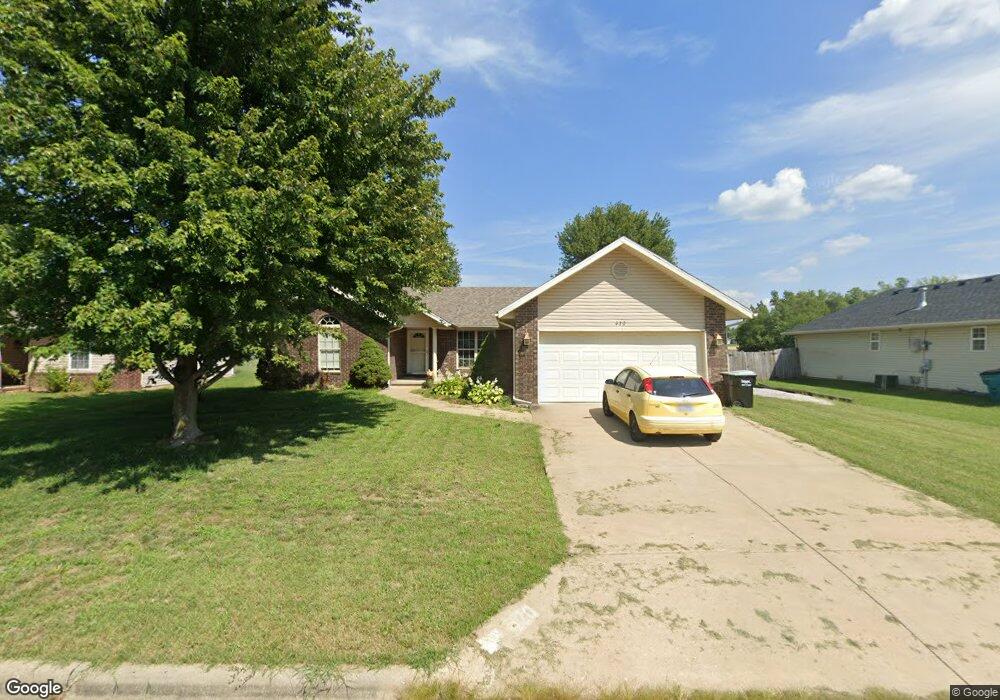
420 N Butternut Rd Republic, MO 65738
Estimated Value: $229,000 - $244,502
3
Beds
2
Baths
1,310
Sq Ft
$183/Sq Ft
Est. Value
About This Home
This home is located at 420 N Butternut Rd, Republic, MO 65738 and is currently estimated at $239,126, approximately $182 per square foot. 420 N Butternut Rd is a home located in Greene County with nearby schools including Schofield Elementary School, Republic Middle School, and Republic High School.
Ownership History
Date
Name
Owned For
Owner Type
Purchase Details
Closed on
May 23, 2014
Sold by
Patnaude Roger M and Patnaude Patricia P
Bought by
Rensch David
Current Estimated Value
Purchase Details
Closed on
Feb 27, 2007
Sold by
Montgomery Deann M
Bought by
Patnaude Roger M and Patnaude Patricia P
Home Financials for this Owner
Home Financials are based on the most recent Mortgage that was taken out on this home.
Original Mortgage
$125,600
Interest Rate
5.75%
Mortgage Type
Purchase Money Mortgage
Purchase Details
Closed on
Feb 24, 2005
Sold by
Corner Kevin L and Corner Kerri K
Bought by
Montgomery Deann M
Home Financials for this Owner
Home Financials are based on the most recent Mortgage that was taken out on this home.
Original Mortgage
$113,700
Interest Rate
6%
Mortgage Type
Purchase Money Mortgage
Create a Home Valuation Report for This Property
The Home Valuation Report is an in-depth analysis detailing your home's value as well as a comparison with similar homes in the area
Home Values in the Area
Average Home Value in this Area
Purchase History
| Date | Buyer | Sale Price | Title Company |
|---|---|---|---|
| Rensch David | -- | None Available | |
| Patnaude Roger M | -- | Lincoln Evans Land Title Co | |
| Montgomery Deann M | -- | Lincoln Evans Land Title Com |
Source: Public Records
Mortgage History
| Date | Status | Borrower | Loan Amount |
|---|---|---|---|
| Previous Owner | Patnaude Roger M | $125,600 | |
| Previous Owner | Montgomery Deann M | $113,700 |
Source: Public Records
Tax History Compared to Growth
Tax History
| Year | Tax Paid | Tax Assessment Tax Assessment Total Assessment is a certain percentage of the fair market value that is determined by local assessors to be the total taxable value of land and additions on the property. | Land | Improvement |
|---|---|---|---|---|
| 2025 | $1,683 | $34,110 | $5,700 | $28,410 |
| 2024 | $1,683 | $30,130 | $4,750 | $25,380 |
| 2023 | $1,651 | $30,130 | $4,750 | $25,380 |
| 2022 | $1,426 | $25,900 | $4,750 | $21,150 |
| 2021 | $1,417 | $25,900 | $4,750 | $21,150 |
| 2020 | $1,331 | $23,940 | $4,750 | $19,190 |
| 2019 | $1,326 | $23,940 | $4,750 | $19,190 |
| 2018 | $1,209 | $21,090 | $3,800 | $17,290 |
| 2017 | $1,199 | $19,720 | $3,800 | $15,920 |
| 2016 | $1,134 | $19,720 | $3,800 | $15,920 |
| 2015 | $1,130 | $19,720 | $3,800 | $15,920 |
| 2014 | $1,137 | $19,670 | $3,800 | $15,870 |
Source: Public Records
Map
Nearby Homes
- 135 N Bonnie Ave
- 520 N College Ave
- 347 W Elm St
- 532 N College Ave
- 626 N Phelps Ave
- 707 N College Ave
- 533 N Main St
- 401 Ethan Ave
- 1213 N London Place
- 1021 W Crestview Ln
- 000 W Crestview Ln
- 207 W Broad St
- 0 Highway 60 Unit 60308100
- 0 Highway 60 Unit 60308095
- 530 Ashley St
- 1135 W Broad St
- .94+/- Ac Highway 60
- 573 S Charlotte Ct
- 2450 Highway 60
- 1128 N Blackstone Ave
- 420 N Butternut Ave
- 426 N Butternut Ave
- 426 N Butternut Rd
- 414 N Butternut Rd
- 432 N Butternut Rd
- 432 N Butternut Ave
- 425 N Butternut Ave
- 419 N Butternut Rd
- 425 N Butternut Rd
- 408 N Butternut Ave
- 408 N Butternut Rd
- 431 N Butternut Ave
- 431 N Butternut Rd
- 413 N Butternut Rd
- 502 N Butternut Rd
- 501 N Butternut Rd
- 402 N Butternut Rd
- 508 N Butternut Ave
- 508 N Butternut Rd
- 532 Meadows Dr