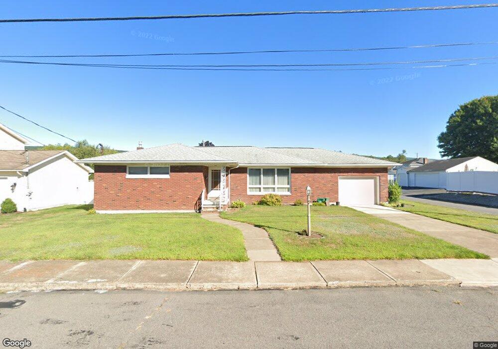
420 Phillips St Old Forge, PA 18518
Estimated Value: $181,493 - $310,000
Studio
--
Bath
--
Sq Ft
11,195
Sq Ft Lot
About This Home
This home is located at 420 Phillips St, Old Forge, PA 18518 and is currently estimated at $234,123. 420 Phillips St is a home located in Lackawanna County with nearby schools including Old Forge Elementary School, Old Forge Junior/Senior High School, and Triboro Christian Academy.
Ownership History
Date
Name
Owned For
Owner Type
Purchase Details
Closed on
Apr 9, 2025
Sold by
Polanchik Daria
Bought by
Daria Polanchik Living Trust and Polanchik
Current Estimated Value
Purchase Details
Closed on
Jan 17, 2020
Sold by
Polanchik Paul and Polanchik Daria
Bought by
Polanchik Daria
Purchase Details
Closed on
Dec 21, 2016
Sold by
Polanchik Dorothy and Polanchik Paul
Bought by
Polanchik Paul and Polanchik Daria
Purchase Details
Closed on
Apr 26, 1965
Bought by
Polanchik Steve and Polanchik Dorothy
Create a Home Valuation Report for This Property
The Home Valuation Report is an in-depth analysis detailing your home's value as well as a comparison with similar homes in the area
Home Values in the Area
Average Home Value in this Area
Purchase History
| Date | Buyer | Sale Price | Title Company |
|---|---|---|---|
| Daria Polanchik Living Trust | -- | None Listed On Document | |
| Polanchik Daria | $120,000 | None Available | |
| Polanchik Paul | -- | None Available | |
| Polanchik Steve | $2,200 | -- |
Source: Public Records
Tax History
| Year | Tax Paid | Tax Assessment Tax Assessment Total Assessment is a certain percentage of the fair market value that is determined by local assessors to be the total taxable value of land and additions on the property. | Land | Improvement |
|---|---|---|---|---|
| 2025 | $4,020 | $15,500 | $2,000 | $13,500 |
| 2024 | $3,585 | $15,500 | $2,000 | $13,500 |
| 2023 | $3,585 | $15,500 | $2,000 | $13,500 |
| 2022 | $3,465 | $15,500 | $2,000 | $13,500 |
| 2021 | $3,370 | $15,500 | $2,000 | $13,500 |
| 2020 | $3,331 | $15,500 | $2,000 | $13,500 |
| 2019 | $3,192 | $15,500 | $2,000 | $13,500 |
| 2018 | $3,161 | $15,500 | $2,000 | $13,500 |
| 2017 | $3,161 | $15,500 | $2,000 | $13,500 |
| 2016 | $1,857 | $15,500 | $2,000 | $13,500 |
| 2015 | -- | $15,500 | $2,000 | $13,500 |
| 2014 | -- | $15,500 | $2,000 | $13,500 |
Source: Public Records
Map
Nearby Homes
- 133 Corcoran St
- Lot 02 Casey Ave
- Lot 02 Sibley Ave
- 184 N Main St
- 906 Sampson St
- 307 Charles St
- 618 Maple St
- 630 Oak St
- 800 W Oak St
- 513 S Washington St
- 602 S Main St
- 1213 1215 Lori Ln
- 503 George St
- 405 Milwaukee Ave
- 1215 Mine St
- 254 Hoover St
- 421 W Mary St
- 208 W Taylor St
- Parcel B Davis Ct
- 112 E Taylor St
- 418 Phillips St
- 502 Mcclure St
- 500 Mcclure St
- 504 Mcclure St
- 416 Phillips St
- 507 von Bergen St
- 419 Phillips St
- 506 Mcclure St
- 416 Mcclure St
- 417 Phillips St
- 506 Mcclure Ave
- 415 Phillips St
- L 40, 41 Phillips St
- 414 Mcclure St
- 509 von Bergen St
- 0 Phillips St
- 413 Phillips St
- 412 Mcclure St
- Parcel 4 von Bergen St
- 503 von Bergen St
Your Personal Tour Guide
Ask me questions while you tour the home.