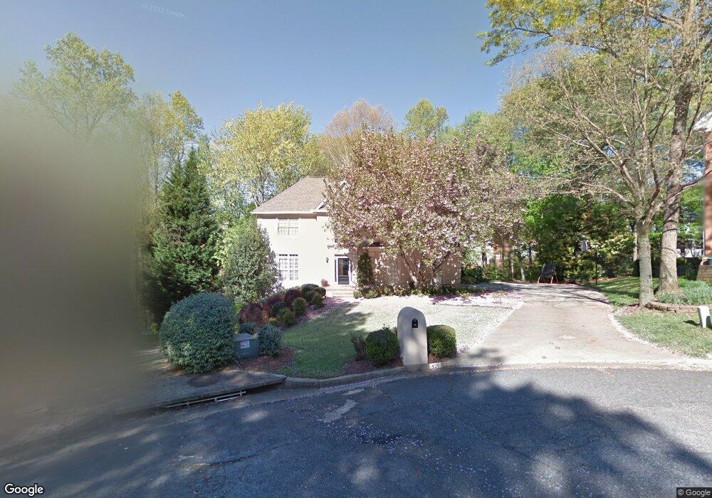
420 Rheims Way Alpharetta, GA 30022
Estimated Value: $700,000 - $768,000
4
Beds
3
Baths
2,140
Sq Ft
$344/Sq Ft
Est. Value
About This Home
This home is located at 420 Rheims Way, Alpharetta, GA 30022 and is currently estimated at $735,226, approximately $343 per square foot. 420 Rheims Way is a home located in Fulton County with nearby schools including Ocee Elementary School, Taylor Road Middle School, and Chattahoochee High School.
Ownership History
Date
Name
Owned For
Owner Type
Purchase Details
Closed on
Sep 27, 2006
Sold by
Kupka Joseph P and Kupka Rhonda K
Bought by
Smith James T and Smith Martha J
Current Estimated Value
Home Financials for this Owner
Home Financials are based on the most recent Mortgage that was taken out on this home.
Original Mortgage
$285,000
Outstanding Balance
$168,273
Interest Rate
6.27%
Mortgage Type
New Conventional
Estimated Equity
$566,953
Create a Home Valuation Report for This Property
The Home Valuation Report is an in-depth analysis detailing your home's value as well as a comparison with similar homes in the area
Home Values in the Area
Average Home Value in this Area
Purchase History
| Date | Buyer | Sale Price | Title Company |
|---|---|---|---|
| Smith James T | $380,000 | -- |
Source: Public Records
Mortgage History
| Date | Status | Borrower | Loan Amount |
|---|---|---|---|
| Open | Smith James T | $285,000 |
Source: Public Records
Tax History Compared to Growth
Tax History
| Year | Tax Paid | Tax Assessment Tax Assessment Total Assessment is a certain percentage of the fair market value that is determined by local assessors to be the total taxable value of land and additions on the property. | Land | Improvement |
|---|---|---|---|---|
| 2025 | $730 | $283,840 | $98,080 | $185,760 |
| 2023 | $6,954 | $246,360 | $71,560 | $174,800 |
| 2022 | $3,493 | $184,600 | $48,600 | $136,000 |
| 2021 | $4,086 | $163,000 | $47,240 | $115,760 |
| 2020 | $4,108 | $161,080 | $46,680 | $114,400 |
| 2019 | $618 | $162,280 | $43,640 | $118,640 |
| 2018 | $3,838 | $158,440 | $42,600 | $115,840 |
| 2017 | $3,518 | $135,560 | $26,160 | $109,400 |
| 2016 | $3,424 | $131,480 | $26,160 | $105,320 |
| 2015 | $3,992 | $131,480 | $26,160 | $105,320 |
| 2014 | $3,282 | $119,800 | $29,120 | $90,680 |
Source: Public Records
Map
Nearby Homes
- 125 Sandridge Ct
- 825 Highland Bend Cove
- 10845 Carrissa Trail
- 465 Kirkstall Trail
- 3396 Carverton Ln
- 3430 Waters Mill Dr
- 710 Country Manor Way
- 120 Thome Dr
- 105 Kimball Bridge Cove
- 10900 Wittenridge Dr Unit H8
- 10900 Wittenridge Dr Unit C7
- 3962 Erin Dr
- 10515 Colony Glen Dr Unit 2
- 115 Willow View Point
- 10415 Plantation Bridge Dr
- 4475 Hawthorn Cir
- 3195 Waters Mill Dr
- 870 Longstone Landing
- 10405 Meadow Crest Ln
- 320 Snowgoose Ct
- 410 Rheims Way
- 415 Rheims Way Unit 353
- 415 Rheims Way Unit III
- 710 Arkwith Way
- 720 Arkwith Way
- 160 Sandridge Ct
- 150 Sandridge Ct
- 170 Sandridge Ct
- 345 Welwyn Walk
- 325 Welwyn Walk
- 140 Sandridge Ct
- 730 Arkwith Way
- 700 Arkwith Way
- 315 Welwyn Walk Unit III
- 355 Welwyn Walk
- 365 Welwyn Walk
- 715 Arkwith Way Unit 3
- 605 Varina Way Unit 3
- 740 Arkwith Way
- 305 Welwyn Walk