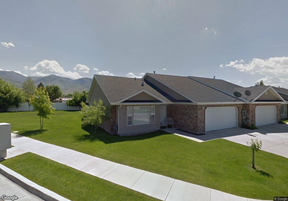
420 S 80 W Smithfield, UT 84335
Estimated Value: $320,515 - $353,000
3
Beds
2
Baths
1,292
Sq Ft
$262/Sq Ft
Est. Value
About This Home
This home is located at 420 S 80 W, Smithfield, UT 84335 and is currently estimated at $337,879, approximately $261 per square foot. 420 S 80 W is a home located in Cache County with nearby schools including Summit School, Cedar Ridge School, and Cedar Ridge Middle School.
Ownership History
Date
Name
Owned For
Owner Type
Purchase Details
Closed on
Jan 18, 2011
Sold by
Hansen Lucinda M
Bought by
Hansen Mary Jo and Whiteley Patricia C
Current Estimated Value
Purchase Details
Closed on
Oct 28, 2009
Sold by
Grindeland Douglas Elwood
Bought by
Grindeland Douglas E and Grindeland Glenda J
Home Financials for this Owner
Home Financials are based on the most recent Mortgage that was taken out on this home.
Original Mortgage
$40,000
Interest Rate
5%
Mortgage Type
New Conventional
Purchase Details
Closed on
Nov 3, 2008
Sold by
Bassett E Norman and Bassett Cleta R
Bought by
West Donald Preston and West Leola May
Purchase Details
Closed on
Oct 12, 2005
Sold by
Co Ax Enterprises Inc
Bought by
Bassett E Norman and Bassett Cleta R
Home Financials for this Owner
Home Financials are based on the most recent Mortgage that was taken out on this home.
Original Mortgage
$53,100
Interest Rate
5.63%
Mortgage Type
New Conventional
Create a Home Valuation Report for This Property
The Home Valuation Report is an in-depth analysis detailing your home's value as well as a comparison with similar homes in the area
Home Values in the Area
Average Home Value in this Area
Purchase History
| Date | Buyer | Sale Price | Title Company |
|---|---|---|---|
| Hansen Mary Jo | -- | Cache Title Company | |
| Hansen Lucinda M | -- | Cache Title Company | |
| Grindeland Douglas E | -- | American Secure Title | |
| Grindeland Douglas Elwood | -- | American Secure Title | |
| West Donald Preston | -- | Hickman Land Title Company | |
| Bassett E Norman | -- | Hickman Land Title Company |
Source: Public Records
Mortgage History
| Date | Status | Borrower | Loan Amount |
|---|---|---|---|
| Previous Owner | Grindeland Douglas Elwood | $40,000 | |
| Previous Owner | Bassett E Norman | $53,100 |
Source: Public Records
Tax History Compared to Growth
Tax History
| Year | Tax Paid | Tax Assessment Tax Assessment Total Assessment is a certain percentage of the fair market value that is determined by local assessors to be the total taxable value of land and additions on the property. | Land | Improvement |
|---|---|---|---|---|
| 2025 | $1,447 | $193,740 | $0 | $0 |
| 2024 | $1,400 | $175,870 | $0 | $0 |
| 2023 | $1,464 | $173,910 | $0 | $0 |
| 2022 | $1,488 | $173,910 | $0 | $0 |
| 2021 | $1,241 | $221,530 | $55,000 | $166,530 |
| 2020 | $1,242 | $206,800 | $55,000 | $151,800 |
| 2019 | $1,145 | $181,800 | $30,000 | $151,800 |
| 2018 | $1,055 | $162,000 | $30,000 | $132,000 |
| 2017 | $984 | $82,500 | $0 | $0 |
| 2016 | $1,001 | $82,500 | $0 | $0 |
| 2015 | $915 | $75,070 | $0 | $0 |
| 2014 | $897 | $75,070 | $0 | $0 |
| 2013 | -- | $75,070 | $0 | $0 |
Source: Public Records
Map
Nearby Homes
- 98 W 400 S
- 423 S 80 W
- 339 S Main St
- 240 W 300 S
- 616 S Main St
- 621 S 85 E Unit 24
- 635 S 85 E Unit 26
- 639 S 85 E Unit 28
- Mountain Valley Plan at Mountain Valley Townhome Community - Mountain Valley
- 657 S 85 E Unit 33
- 206 S 100 E
- 118 E 620 S
- 3193 N 2400 W
- 104 E 650 S
- 115 E 690 S
- 438 S 400 W
- 138 W 650 N
- 613 S 280 E
- 350 E 400 S
- 219 E 830 S