Estimated Value: $251,000 - $329,844
3
Beds
1
Bath
2,226
Sq Ft
$135/Sq Ft
Est. Value
About This Home
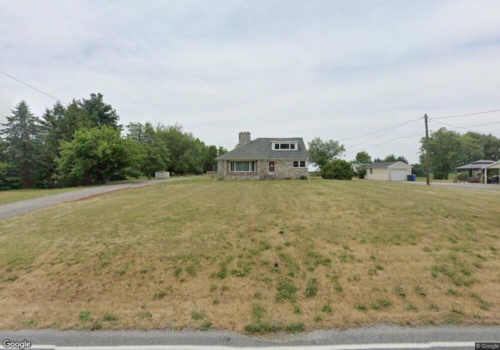
This home is located at 4200 Lewisberry Rd, York, PA 17404 and is currently estimated at $300,211, approximately $134 per square foot. 4200 Lewisberry Rd is a home located in York County with nearby schools including Northeastern Senior High School and Bible Baptist Christian Academy.
Ownership History
Date
Name
Owned For
Owner Type
Purchase Details
Closed on
Jun 15, 2023
Sold by
Fix Susan E
Bought by
Hughes Eugene and Hughes Shirley Ann
Current Estimated Value
Purchase Details
Closed on
Jun 10, 1999
Sold by
Fix Susan E Griffin and Griffin Susan E
Bought by
Fix Susan E Griffin
Home Financials for this Owner
Home Financials are based on the most recent Mortgage that was taken out on this home.
Original Mortgage
$43,500
Interest Rate
6.99%
Purchase Details
Closed on
Jan 16, 1985
Bought by
Griffin Stephen L and Griffin Susan E
Create a Home Valuation Report for This Property
The Home Valuation Report is an in-depth analysis detailing your home's value as well as a comparison with similar homes in the area
Home Values in the Area
Average Home Value in this Area
Purchase History
| Date | Buyer | Sale Price | Title Company |
|---|---|---|---|
| Hughes Eugene | $200,000 | None Listed On Document | |
| Fix Susan E Griffin | -- | -- | |
| Griffin Stephen L | $45,000 | -- |
Source: Public Records
Mortgage History
| Date | Status | Borrower | Loan Amount |
|---|---|---|---|
| Closed | Fix Susan E Griffin | $43,500 |
Source: Public Records
Tax History Compared to Growth
Tax History
| Year | Tax Paid | Tax Assessment Tax Assessment Total Assessment is a certain percentage of the fair market value that is determined by local assessors to be the total taxable value of land and additions on the property. | Land | Improvement |
|---|---|---|---|---|
| 2025 | $5,564 | $154,800 | $44,080 | $110,720 |
| 2024 | $5,438 | $154,800 | $44,080 | $110,720 |
| 2023 | $5,379 | $153,110 | $44,080 | $109,030 |
| 2022 | $5,345 | $153,110 | $44,080 | $109,030 |
| 2021 | $5,198 | $153,110 | $44,080 | $109,030 |
| 2020 | $5,198 | $153,110 | $44,080 | $109,030 |
| 2019 | $5,129 | $153,110 | $44,080 | $109,030 |
| 2018 | $5,105 | $153,110 | $44,080 | $109,030 |
| 2017 | $5,105 | $153,110 | $44,080 | $109,030 |
| 2016 | $0 | $153,110 | $44,080 | $109,030 |
| 2015 | -- | $153,110 | $44,080 | $109,030 |
| 2014 | -- | $153,110 | $44,080 | $109,030 |
Source: Public Records
Map
Nearby Homes
- 130 Locust Run Dr
- 225 E Canal Rd
- 1050 Matthew Dr
- 435 Fisher Dr
- 40 Heather Way
- 365 Fisher Dr
- 240 Fisher Dr
- 85 Thomas Dr
- 273 Copenhaffer Rd
- 514 Darrow Rd
- 140 Eli Dr
- 157 Eli Dr
- 130 Eli Dr
- 151 Eli Dr
- 135 Eli Dr
- Woodford Plan at Welbourne Reserve
- Sebastian Plan at Welbourne Reserve
- Covington Plan at Welbourne Reserve
- Parker Plan at Welbourne Reserve
- Lachlan Plan at Welbourne Reserve
- 4210 Lewisberry Rd
- 4210 Lewisberry Rd
- 4215 Lewisberry Rd
- 4220 Lewisberry Rd
- 4180 Lewisberry Rd
- 4205 Lewisberry Rd
- 4219 Lewisberry Rd
- 4190 Lewisberry Rd
- site 999 Lewisberry Rd Unit 240
- 4185 Lewisberry Rd
- 4185 Lewisberry Rd
- 4185 Lewisberry Rd Unit 2
- Lot 2 - 41 Lewisberry Rd
- 4160 Lewisberry Rd
- 4145 Lewisberry Rd
- 4135 Lewisberry Rd
- 645 Locust Run Dr
- 4140 Lewisberry Rd
- 635 Locust Run Dr
- 625 Locust Run Dr