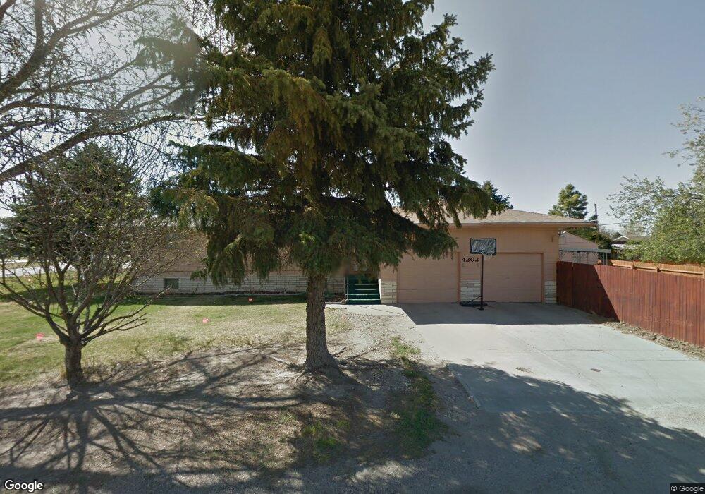
4202 Apple Ave Scottsbluff, NE 69361
Estimated Value: $244,282 - $319,000
3
Beds
2
Baths
1,618
Sq Ft
$170/Sq Ft
Est. Value
About This Home
This home is located at 4202 Apple Ave, Scottsbluff, NE 69361 and is currently estimated at $275,071, approximately $170 per square foot. 4202 Apple Ave is a home located in Scotts Bluff County with nearby schools including Lincoln Heights Elementary School, Bluffs Middle School, and Scottsbluff Senior High School.
Ownership History
Date
Name
Owned For
Owner Type
Purchase Details
Closed on
Aug 18, 2006
Sold by
Parks Carmen G
Bought by
Resendiz Anselmo and Resendiz Connie
Current Estimated Value
Home Financials for this Owner
Home Financials are based on the most recent Mortgage that was taken out on this home.
Original Mortgage
$89,000
Outstanding Balance
$52,908
Interest Rate
6.77%
Mortgage Type
New Conventional
Estimated Equity
$222,163
Create a Home Valuation Report for This Property
The Home Valuation Report is an in-depth analysis detailing your home's value as well as a comparison with similar homes in the area
Home Values in the Area
Average Home Value in this Area
Purchase History
| Date | Buyer | Sale Price | Title Company |
|---|---|---|---|
| Resendiz Anselmo | $125,000 | -- |
Source: Public Records
Mortgage History
| Date | Status | Borrower | Loan Amount |
|---|---|---|---|
| Open | Resendiz Anselmo | $89,000 |
Source: Public Records
Tax History
| Year | Tax Paid | Tax Assessment Tax Assessment Total Assessment is a certain percentage of the fair market value that is determined by local assessors to be the total taxable value of land and additions on the property. | Land | Improvement |
|---|---|---|---|---|
| 2025 | $2,237 | $209,735 | $18,380 | $191,355 |
| 2024 | $2,238 | $205,200 | $18,380 | $186,820 |
| 2023 | $2,995 | $161,949 | $13,679 | $148,270 |
| 2022 | $2,995 | $161,949 | $13,679 | $148,270 |
| 2021 | $2,963 | $157,630 | $13,679 | $143,951 |
| 2020 | $2,757 | $145,744 | $13,679 | $132,065 |
| 2019 | $2,733 | $144,660 | $12,595 | $132,065 |
| 2018 | $2,523 | $132,654 | $12,595 | $120,059 |
| 2017 | $2,532 | $132,654 | $12,595 | $120,059 |
| 2016 | $2,535 | $132,654 | $12,595 | $120,059 |
| 2015 | $2,515 | $132,654 | $12,595 | $120,059 |
| 2014 | $2,337 | $132,654 | $12,595 | $120,059 |
| 2012 | -- | $129,157 | $12,595 | $116,562 |
Source: Public Records
Map
Nearby Homes
- 2817 W 42nd St
- 4501 Cottonwood Ave
- 2307 W 42nd St Unit 46
- 1012 W 36th St
- 90208 County Road 19
- 1011 W 27th St
- 1010 W 29th St
- TBD W 36th St
- 0 W 36th St Unit 20254154
- 721 W 33rd St
- 501 W 38th St
- 16 Bluestem
- 3918 Avenue D
- 2809 Avenue I
- 910 Mockingbird Dr
- 410 Sandra Ct
- 2801 Avenue H
- 3405 Ross Ave
- 2614 Avenue D
- 2417 Avenue F
- 2609 W 42nd St
- 4210 Apple Ave
- 90018 County Road 20
- 2617 W 42nd St
- 4209 Birch Ave
- 2525 W 42nd St
- 2614 W 42nd St
- 4218 Apple Ave
- 2626 W 42nd St
- 4217 Birch Ave
- 2701 W 42nd St
- 4302 Apple Ave
- 4210 Birch Ave
- 4301 Birch Ave
- 2709 W 42nd St
- 4218 Birch Ave
- 4310 Apple Ave
- 4302 Shady Ln
- 4309 Birch Ave
- 4302 Birch Ave
Your Personal Tour Guide
Ask me questions while you tour the home.