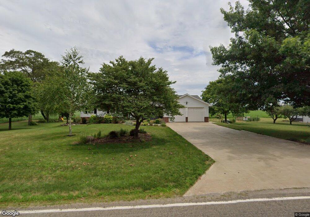
4205 Adams Ridge Rd Defiance, OH 43512
Estimated Value: $226,000 - $271,000
3
Beds
2
Baths
1,488
Sq Ft
$171/Sq Ft
Est. Value
About This Home
This home is located at 4205 Adams Ridge Rd, Defiance, OH 43512 and is currently estimated at $254,474, approximately $171 per square foot. 4205 Adams Ridge Rd is a home located in Defiance County with nearby schools including Tinora Elementary School, Noble Elementary School, and Tinora Middle School.
Ownership History
Date
Name
Owned For
Owner Type
Purchase Details
Closed on
Dec 4, 2019
Sold by
Beck Charles T and Beck Susan Y
Bought by
Beck Charles T and Beck Susan Y
Current Estimated Value
Purchase Details
Closed on
Oct 28, 2010
Sold by
Beck Charles T and Beck Susan K
Bought by
Beck Charles T and Beck Susan Y
Purchase Details
Closed on
Jan 1, 1992
Bought by
Beck Charles T and Beck Susan Y
Create a Home Valuation Report for This Property
The Home Valuation Report is an in-depth analysis detailing your home's value as well as a comparison with similar homes in the area
Home Values in the Area
Average Home Value in this Area
Purchase History
| Date | Buyer | Sale Price | Title Company |
|---|---|---|---|
| Beck Charles T | -- | None Available | |
| Beck Charles T | -- | -- | |
| Beck Charles T | -- | -- |
Source: Public Records
Tax History Compared to Growth
Tax History
| Year | Tax Paid | Tax Assessment Tax Assessment Total Assessment is a certain percentage of the fair market value that is determined by local assessors to be the total taxable value of land and additions on the property. | Land | Improvement |
|---|---|---|---|---|
| 2024 | $2,439 | $69,980 | $6,620 | $63,360 |
| 2023 | $2,439 | $69,980 | $6,620 | $63,360 |
| 2022 | $1,866 | $45,530 | $6,050 | $39,480 |
| 2021 | $1,866 | $45,530 | $6,050 | $39,480 |
| 2020 | $1,873 | $45,530 | $6,050 | $39,480 |
| 2019 | $1,765 | $43,830 | $5,960 | $37,870 |
| 2018 | $1,822 | $43,830 | $5,960 | $37,870 |
| 2017 | $1,855 | $43,824 | $5,957 | $37,867 |
| 2016 | $1,701 | $45,507 | $5,736 | $39,771 |
| 2015 | $906 | $45,507 | $5,736 | $39,771 |
| 2014 | $906 | $45,507 | $5,736 | $39,771 |
| 2013 | $906 | $45,507 | $5,736 | $39,771 |
| 2012 | $906 | $45,508 | $5,737 | $39,771 |
Source: Public Records
Map
Nearby Homes
- 29232 Coressel Rd
- 26825 Behrens Rd
- 26761 Behrens Rd
- 6767 Independence Rd
- 23648 County Rd S
- 20401 U S 6
- 19972 County Road X
- 19950 County Road X
- 19913 County Road X
- 6909 Ohio 66
- 0 Saint Rt 66
- 23132 Coressel Rd
- 405 W High St
- 212 E High St
- 8208 N State Route 66 Unit 8219
- 1275 Pinehurst Dr
- 850 Deerwood Dr
- 846 Deerwood Dr
- 75 Capri Dr
- 0 Westmoreland Ave
- 4307 Adams Ridge Rd
- 28242 Coressel Rd
- 3878 Adams Ridge Rd
- 28455 Coressel Rd
- 4585 Adams Ridge Rd
- 4615 Adams Ridge Rd
- 3741 Adams Ridge Rd
- 27988 Coressel Rd
- 28035 Mekus Rd
- 3662 Adams Ridge Rd
- 4745 Adams Ridge Rd
- 29032 Coressel Rd
- 27878 Coressel Rd
- 4792 Adams Ridge Rd
- 3541 Adams Ridge Rd
- 03541 Adams Ridge Rd
- 3453 Adams Ridge Rd
- 28276 Gerken Rd
- 28478 Gerken Rd
- 27649 Coressel Rd