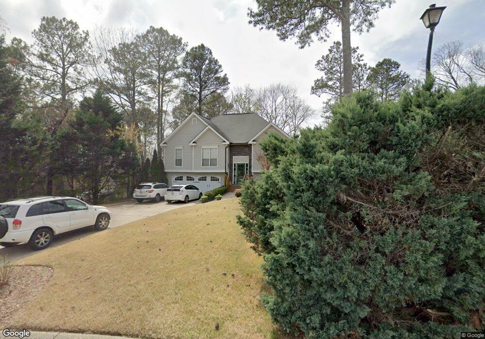
4205 Pheasant Run Trace Cumming, GA 30028
Estimated Value: $375,916 - $411,000
3
Beds
2
Baths
1,368
Sq Ft
$283/Sq Ft
Est. Value
About This Home
This home is located at 4205 Pheasant Run Trace, Cumming, GA 30028 and is currently estimated at $386,479, approximately $282 per square foot. 4205 Pheasant Run Trace is a home located in Forsyth County with nearby schools including Poole's Mill Elementary School, Liberty Middle School, and North Forsyth High School.
Ownership History
Date
Name
Owned For
Owner Type
Purchase Details
Closed on
Nov 15, 1996
Sold by
Steve Arthur Constr Co
Bought by
Judy Eugene Janine
Current Estimated Value
Purchase Details
Closed on
Sep 11, 1996
Sold by
Means Bros Inc
Bought by
Steve Arthur Const
Create a Home Valuation Report for This Property
The Home Valuation Report is an in-depth analysis detailing your home's value as well as a comparison with similar homes in the area
Home Values in the Area
Average Home Value in this Area
Purchase History
| Date | Buyer | Sale Price | Title Company |
|---|---|---|---|
| Judy Eugene Janine | $126,200 | -- | |
| Steve Arthur Const | $23,400 | -- |
Source: Public Records
Mortgage History
| Date | Status | Borrower | Loan Amount |
|---|---|---|---|
| Closed | Steve Arthur Const | $0 |
Source: Public Records
Tax History Compared to Growth
Tax History
| Year | Tax Paid | Tax Assessment Tax Assessment Total Assessment is a certain percentage of the fair market value that is determined by local assessors to be the total taxable value of land and additions on the property. | Land | Improvement |
|---|---|---|---|---|
| 2025 | $352 | $152,024 | $48,000 | $104,024 |
| 2024 | $352 | $141,532 | $46,000 | $95,532 |
| 2023 | $248 | $128,112 | $38,000 | $90,112 |
| 2022 | $2,248 | $81,460 | $18,000 | $63,460 |
| 2021 | $1,902 | $81,460 | $18,000 | $63,460 |
| 2020 | $1,846 | $78,768 | $18,000 | $60,768 |
| 2019 | $1,827 | $77,672 | $18,000 | $59,672 |
| 2018 | $1,492 | $61,060 | $14,000 | $47,060 |
| 2017 | $1,454 | $58,968 | $14,000 | $44,968 |
| 2016 | $1,454 | $58,968 | $14,000 | $44,968 |
| 2015 | $1,368 | $54,768 | $14,000 | $40,768 |
| 2014 | $1,190 | $49,520 | $0 | $0 |
Source: Public Records
Map
Nearby Homes
- 4215 Pheasant Run Trace
- 4305 Hunters Walk Way
- 4275 Hunters Walk Way
- 3880 Deer Run Dr
- 4035 Haven Way
- 3930 Pheasant Run Trace
- 4040 Haven Way
- 4030 Haven Way
- 4020 Haven Way
- 3985 Haven Way
- 3975 Haven Way
- 3965 Haven Way
- 3945 Silverthorn Trace
- 3705 Williams Point Dr
- BELLVIEW Plan at Haven Abbey
- WESTERLY Plan at Haven Abbey
- LYNNBROOK Plan at Haven Abbey
- 3905 Hurt Bridge Rd
- GRAYSON Plan at Haven Abbey
- 4150 Starr Creek Rd
- 4220 Penion Point
- 4210 Pheasant Run Trace
- 4225 Penion Point
- 4225 Pheasant Run Trace
- 4135 Pheasant Run Trace
- 4410 Hunters Walk Way Unit 80
- 4410 Hunters Walk Way
- 4390 Hunters Walk Way Unit 81
- 4390 Hunters Walk Way
- 4130 Pheasant Run Trace
- 4230 Pheasant Run Trace
- 4420 Hunters Walk Way Unit 79
- 4420 Hunters Walk Way
- 4380 Hunters Walk Way Unit 82
- 4380 Hunters Walk Way
- 4235 Pheasant Run Trace
- 4125 Pheasant Run Trace
- 4240 Pheasant Run
- 4240 Pheasant Run Trace
- 4430 Hunters Walk Way Unit 78