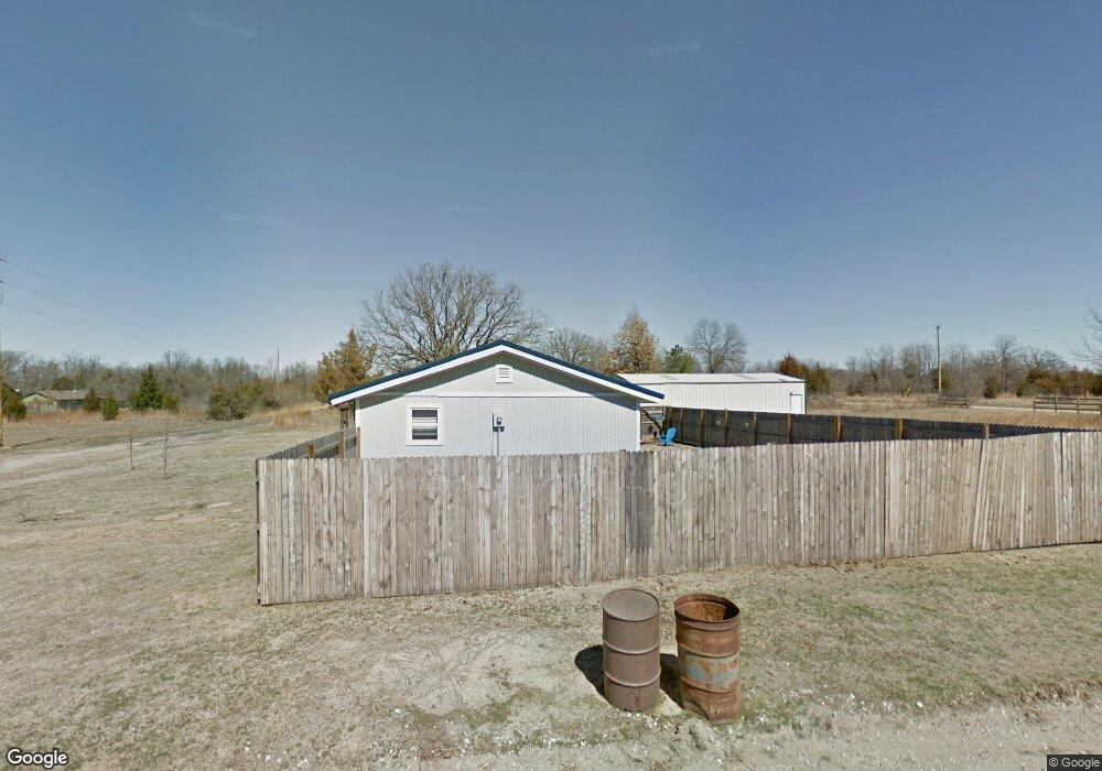
420645 E 1168 Rd Eufaula, OK 74432
Estimated Value: $132,904 - $245,000
3
Beds
1
Bath
1,196
Sq Ft
$159/Sq Ft
Est. Value
About This Home
This home is located at 420645 E 1168 Rd, Eufaula, OK 74432 and is currently estimated at $190,476, approximately $159 per square foot. 420645 E 1168 Rd is a home with nearby schools including Eufaula Elementary School, Eufaula Middle School, and Eufaula High School.
Ownership History
Date
Name
Owned For
Owner Type
Purchase Details
Closed on
Mar 30, 2015
Sold by
Shotwell Donna Jean and Cowen Donna Jean
Bought by
Howell Nancy C
Current Estimated Value
Home Financials for this Owner
Home Financials are based on the most recent Mortgage that was taken out on this home.
Original Mortgage
$29,409
Interest Rate
3.82%
Mortgage Type
New Conventional
Purchase Details
Closed on
Mar 30, 2010
Sold by
Autrey Sharon Ann
Bought by
Shotwell Donna Jeau
Purchase Details
Closed on
Aug 10, 1993
Purchase Details
Closed on
Jul 17, 1992
Create a Home Valuation Report for This Property
The Home Valuation Report is an in-depth analysis detailing your home's value as well as a comparison with similar homes in the area
Purchase History
| Date | Buyer | Sale Price | Title Company |
|---|---|---|---|
| Howell Nancy C | $47,500 | None Available | |
| Shotwell Donna Jeau | $17,000 | None Available | |
| -- | $14,500 | -- | |
| -- | $5,000 | -- |
Source: Public Records
Mortgage History
| Date | Status | Borrower | Loan Amount |
|---|---|---|---|
| Closed | Howell Nancy C | $29,409 |
Source: Public Records
Tax History
| Year | Tax Paid | Tax Assessment Tax Assessment Total Assessment is a certain percentage of the fair market value that is determined by local assessors to be the total taxable value of land and additions on the property. | Land | Improvement |
|---|---|---|---|---|
| 2025 | $428 | $5,894 | $259 | $5,635 |
| 2024 | $412 | $5,894 | $259 | $5,635 |
| 2023 | $412 | $5,555 | $259 | $5,296 |
| 2022 | $347 | $5,181 | $301 | $4,880 |
| 2021 | $351 | $5,181 | $301 | $4,880 |
| 2020 | $351 | $5,181 | $301 | $4,880 |
| 2019 | $354 | $5,181 | $301 | $4,880 |
| 2018 | $348 | $5,181 | $301 | $4,880 |
| 2017 | $348 | $5,181 | $301 | $4,880 |
| 2016 | $350 | $5,181 | $301 | $4,880 |
| 2015 | $221 | $2,674 | $146 | $2,528 |
| 2014 | $209 | $2,546 | $139 | $2,407 |
Source: Public Records
Map
Nearby Homes
- 420707 E 1166 Rd
- 116965 S 4164
- 116307 S 4209 Rd
- 1 E 1167 Rd
- 114996 S 4212 Rd
- 001 Siers Rd
- 002 E 1168 Rd
- 001 E 1168 Rd
- 116565 S 4213 Rd
- 421317 E 1168 Rd
- 421355 E 1168 Rd
- 117525 S 4209 Rd
- 117672 S 4202 Rd
- 0 Lynn Ln Unit 2538038
- 123 S 4214 Loop
- 117720 S 4214 Rd
- 115847 S 4197 Rd
- 421843 E 1163 Rd
- Lot 258 Patriot Pointe
- 119402 S 4214 Loop
- 24 Heathway Rd
- 1425 Hisel Rd
- 1425 Hisel Rd
- 101 Belle Starr Forest Dr
- 1425 Hisel Rd
- 17860 Creekwood Ln
- 0 Belle Starr Rd Unit 1710967
- 116685 S 4206 Rd
- 0 None Unit 1009455
- 0 S 4206 Rd Unit 1936246
- 0 S 4206 Rd Unit 2007721
- Rr 2 Po Box
- 116694 S 4206 Rd
- 101 Heathway Rd
- 116674 S 4206 Rd
- 420713 E 1167 Rd
- 420433 E 1168 Rd
- 116660 S 4206 Rd
- 420676 E 1166 Rd
- 2885 Rr 4
Your Personal Tour Guide
Ask me questions while you tour the home.