
Seller's Agent in 2025
Jason Pope
RE/MAX
(860) 625-2311
9 in this area
104 Total Sales
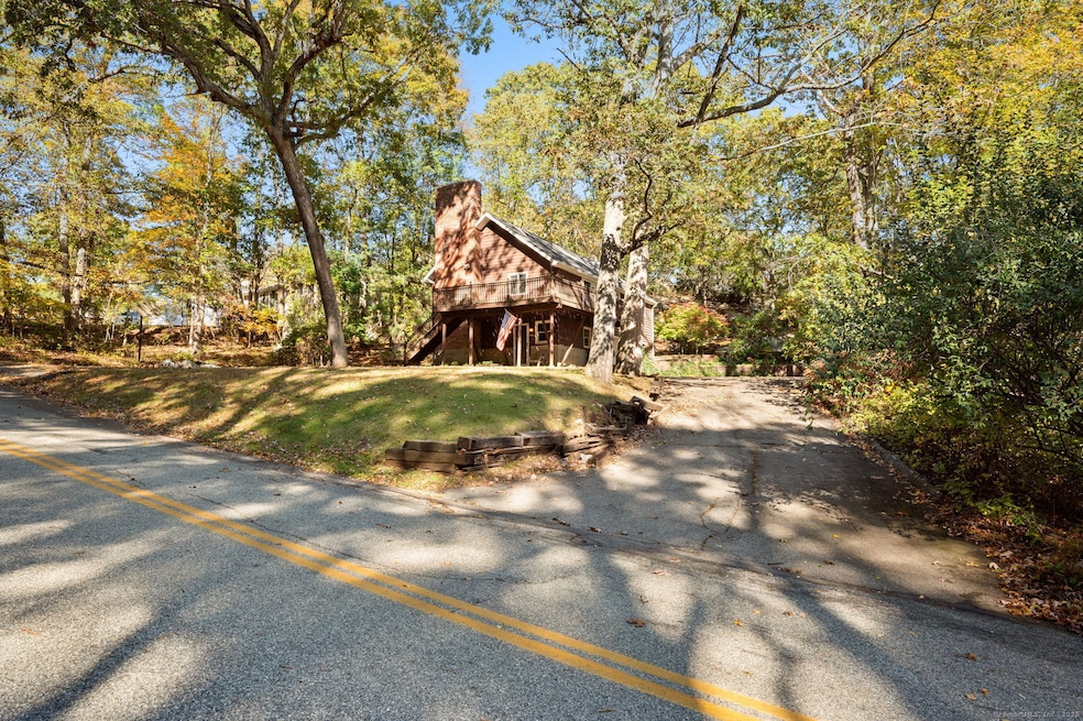
Nestled on a serene and wooded lot, this inviting 3-bedroom, 1-bath home offers the perfect blend of privacy and comfort. Surrounded by nature, the property features a spacious wraparound deck-ideal for morning coffee, outdoor entertaining, or simply enjoying the peaceful surroundings. Inside, you'll find a warm and functional layout with vaulted living room and brick fireplace. The home offers cozy living spaces and is ready for your personal touch. The 2-car garage provides ample room for parking, storage, or even a workshop. Whether you're looking for a quiet retreat or a place to grow, this property offers endless potential in a beautiful natural setting.
Last Agent to Sell the Property
RE/MAX One Brokerage Phone: (860) 625-2311 License #RES.0756085 Listed on: 10/21/2025
Last Buyer's Agent
RE/MAX One Brokerage Phone: (860) 625-2311 License #RES.0756085 Listed on: 10/21/2025
| Date | Type | Sale Price | Title Company |
|---|---|---|---|
| Warranty Deed | $320,000 | -- | |
| Warranty Deed | $130,000 | -- | |
| Warranty Deed | $130,000 | -- | |
| Warranty Deed | $130,000 | -- | |
| Quit Claim Deed | -- | -- | |
| Quit Claim Deed | -- | -- | |
| Foreclosure Deed | -- | -- | |
| Foreclosure Deed | -- | -- | |
| Warranty Deed | $113,000 | -- | |
| Warranty Deed | $113,000 | -- |
| Date | Status | Loan Amount | Loan Type |
|---|---|---|---|
| Open | $288,000 | New Conventional | |
| Previous Owner | $125,450 | Purchase Money Mortgage |
| Date | Event | Price | List to Sale | Price per Sq Ft |
|---|---|---|---|---|
| 12/05/2025 12/05/25 | Sold | $320,000 | +16.4% | $238 / Sq Ft |
| 10/29/2025 10/29/25 | Pending | -- | -- | -- |
| 10/24/2025 10/24/25 | For Sale | $275,000 | -- | $205 / Sq Ft |
| Year | Tax Paid | Tax Assessment Tax Assessment Total Assessment is a certain percentage of the fair market value that is determined by local assessors to be the total taxable value of land and additions on the property. | Land | Improvement |
|---|---|---|---|---|
| 2025 | $3,874 | $134,190 | $28,000 | $106,190 |
| 2024 | $3,726 | $134,190 | $28,000 | $106,190 |
| 2023 | $3,726 | $134,190 | $28,000 | $106,190 |
| 2022 | $3,584 | $134,190 | $28,000 | $106,190 |
| 2021 | $3,756 | $118,300 | $30,800 | $87,500 |
| 2020 | $3,831 | $118,300 | $30,800 | $87,500 |
| 2019 | $3,846 | $118,300 | $30,800 | $87,500 |
| 2018 | $3,754 | $118,300 | $30,790 | $87,510 |
| 2017 | $3,750 | $118,300 | $30,790 | $87,510 |
| 2016 | $3,735 | $122,030 | $38,470 | $83,560 |
| 2015 | $3,735 | $122,030 | $38,470 | $83,560 |
| 2014 | $3,584 | $122,030 | $38,470 | $83,560 |
Seller's Agent in 2025
Jason Pope
RE/MAX
(860) 625-2311
9 in this area
104 Total Sales
Source: SmartMLS
MLS Number: 24134960
APN: MONT-000034-000001-B000000
Disclaimer: Certain information contained herein is derived from information provided by parties other than Homes.com. All information provided is deemed reliable, but is not guaranteed to be accurate and should be independently verified.
![]() IDX information is provided exclusively for personal, non-commercial use, and may not be used for any purpose other than to identify prospective properties consumers may be interested in purchasing. Information is deemed reliable but not guaranteed.
IDX information is provided exclusively for personal, non-commercial use, and may not be used for any purpose other than to identify prospective properties consumers may be interested in purchasing. Information is deemed reliable but not guaranteed.
Ask me questions while you tour the home.