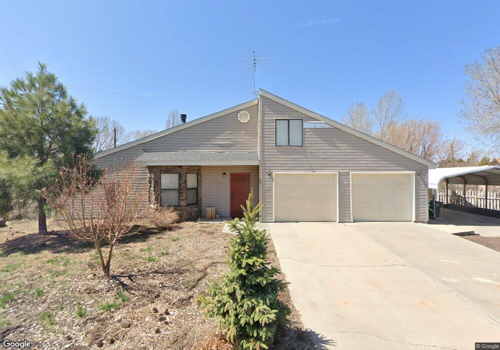
421 N 5th St Williams, AZ 86046
Estimated Value: $416,000 - $513,000
3
Beds
2
Baths
182
Sq Ft
$2,526/Sq Ft
Est. Value
About This Home
This home is located at 421 N 5th St, Williams, AZ 86046 and is currently estimated at $459,714, approximately $2,525 per square foot. 421 N 5th St is a home located in Coconino County with nearby schools including Williams Elementary/Middle School, Williams High School, and Heritage Elementary - Williams.
Ownership History
Date
Name
Owned For
Owner Type
Purchase Details
Closed on
Apr 14, 2020
Sold by
Martin Billy M and Martin Judith M
Bought by
Fischenich Preston W
Current Estimated Value
Home Financials for this Owner
Home Financials are based on the most recent Mortgage that was taken out on this home.
Original Mortgage
$251,750
Outstanding Balance
$222,596
Interest Rate
3.3%
Mortgage Type
New Conventional
Estimated Equity
$237,118
Purchase Details
Closed on
May 10, 2011
Sold by
Bennett Calvin J and Bennett Rebecca M
Bought by
Martin Billy M and Martin Judith M
Home Financials for this Owner
Home Financials are based on the most recent Mortgage that was taken out on this home.
Original Mortgage
$196,891
Interest Rate
4.63%
Mortgage Type
FHA
Purchase Details
Closed on
Dec 1, 1997
Sold by
Brookbank Fonda
Bought by
Bennett Calvin J and Bennett Rebecca M
Create a Home Valuation Report for This Property
The Home Valuation Report is an in-depth analysis detailing your home's value as well as a comparison with similar homes in the area
Home Values in the Area
Average Home Value in this Area
Purchase History
| Date | Buyer | Sale Price | Title Company |
|---|---|---|---|
| Fischenich Preston W | $265,000 | Pioneer Title Agency | |
| Martin Billy M | $189,000 | Pioneer Title Agency Inc | |
| Bennett Calvin J | $24,500 | Transnation Title Insurance |
Source: Public Records
Mortgage History
| Date | Status | Borrower | Loan Amount |
|---|---|---|---|
| Open | Fischenich Preston W | $251,750 | |
| Previous Owner | Martin Billy M | $196,891 |
Source: Public Records
Tax History
| Year | Tax Paid | Tax Assessment Tax Assessment Total Assessment is a certain percentage of the fair market value that is determined by local assessors to be the total taxable value of land and additions on the property. | Land | Improvement |
|---|---|---|---|---|
| 2025 | $1,616 | $37,387 | -- | -- |
| 2024 | $1,616 | $37,432 | -- | -- |
| 2023 | $1,564 | $28,717 | $0 | $0 |
| 2022 | $1,474 | $23,844 | $0 | $0 |
| 2021 | $1,435 | $23,368 | $0 | $0 |
| 2020 | $1,403 | $22,482 | $0 | $0 |
| 2019 | $1,361 | $21,551 | $0 | $0 |
| 2018 | $1,307 | $19,343 | $0 | $0 |
| 2017 | $1,290 | $17,998 | $0 | $0 |
| 2016 | $1,214 | $15,725 | $0 | $0 |
| 2015 | $1,202 | $15,189 | $0 | $0 |
Source: Public Records
Map
Nearby Homes
- 1105 W Morse Ave
- 216 Pinecrest Trail
- 162 Pinecrest Trail
- 118 Pinecrest Trail
- 1124 N Grand Canyon Blvd Unit C
- 1258 W Morse Ave
- 147 Pinecrest Trail
- 224 N Morse Ave
- 218 E Edison Ave
- 241 W Grant Ave
- 304 S 4th St
- 106 W Sherman Ave
- 701 N Airport Rd
- 344 E Route 66
- 215 W Hancock Ave
- 920 W Sheridan Ave
- 401 S 1st St
- 00 S Pine St
- 1011 W Sheridan Ave
- 1021 W Sheridan Ave
Your Personal Tour Guide
Ask me questions while you tour the home.