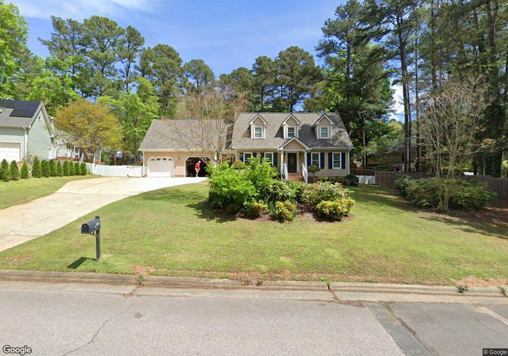
4210 Talcott Dr Unit 112 Durham, NC 27705
West Durham NeighborhoodEstimated Value: $505,347 - $544,000
3
Beds
3
Baths
1,850
Sq Ft
$285/Sq Ft
Est. Value
About This Home
This home is located at 4210 Talcott Dr Unit 112, Durham, NC 27705 and is currently estimated at $526,587, approximately $284 per square foot. 4210 Talcott Dr Unit 112 is a home located in Durham County with nearby schools including Morehead Montessori, Brogden Middle, and Riverside High School.
Ownership History
Date
Name
Owned For
Owner Type
Purchase Details
Closed on
Apr 6, 1999
Sold by
Stovall James E and Stovall Mary Jean M
Bought by
Erdesky Michael J
Current Estimated Value
Home Financials for this Owner
Home Financials are based on the most recent Mortgage that was taken out on this home.
Original Mortgage
$300,000
Interest Rate
6.98%
Mortgage Type
Seller Take Back
Create a Home Valuation Report for This Property
The Home Valuation Report is an in-depth analysis detailing your home's value as well as a comparison with similar homes in the area
Home Values in the Area
Average Home Value in this Area
Purchase History
| Date | Buyer | Sale Price | Title Company |
|---|---|---|---|
| Erdesky Michael J | $300,000 | -- |
Source: Public Records
Mortgage History
| Date | Status | Borrower | Loan Amount |
|---|---|---|---|
| Closed | Erdesky Michael J | $300,000 |
Source: Public Records
Tax History Compared to Growth
Tax History
| Year | Tax Paid | Tax Assessment Tax Assessment Total Assessment is a certain percentage of the fair market value that is determined by local assessors to be the total taxable value of land and additions on the property. | Land | Improvement |
|---|---|---|---|---|
| 2025 | $5,364 | $541,142 | $141,780 | $399,362 |
| 2024 | $4,168 | $298,802 | $62,460 | $236,342 |
| 2023 | $3,914 | $298,802 | $62,460 | $236,342 |
| 2022 | $3,824 | $298,802 | $62,460 | $236,342 |
| 2021 | $3,806 | $298,802 | $62,460 | $236,342 |
| 2020 | $3,717 | $298,802 | $62,460 | $236,342 |
| 2019 | $3,717 | $298,802 | $62,460 | $236,342 |
| 2018 | $3,216 | $237,109 | $55,520 | $181,589 |
| 2017 | $3,193 | $237,109 | $55,520 | $181,589 |
| 2016 | $3,085 | $237,109 | $55,520 | $181,589 |
| 2015 | $2,875 | $207,703 | $37,159 | $170,544 |
| 2014 | $2,875 | $207,703 | $37,159 | $170,544 |
Source: Public Records
Map
Nearby Homes
- 4316 American Dr
- 310 Mckinley St
- 4002 Westfield Dr
- 24 Sunrise Place
- 123 Forest Oaks Dr
- 74 Forest Oaks Dr
- 82 Forest Oaks Dr
- 37 Georgetown Ct
- 210 Silas St
- 28 Prestwick Place
- 108 Panamint Dr
- 13 Providence Ct
- 416 Morreene Rd
- 409 Morreene Rd
- 504 Soapstone Dr Unit 119
- 508 Soapstone Dr Unit 118
- 512 Soapstone Dr Unit 117
- 516 Soapstone Dr Unit 116
- 508 Soapstone Dr
- 504 Soapstone Dr
- 2 Gorham Place
- 508 Constitution Dr
- 514 Constitution Dr
- 6 Gorham Place
- 502 Constitution Dr
- 4211 Talcott Dr
- 4207 Talcott Dr
- 500 Constitution Dr
- 10 Gorham Place
- 3 Gorham Place
- 600 Constitution Dr
- 4301 Talcott Dr
- 422 Constitution Dr
- 9 Gorham Place
- 507 Constitution Dr
- 515 Constitution Dr
- 511 Constitution Dr
- 14 Gorham Place
- 4135 Westfield Dr
- 14 Barrington Place