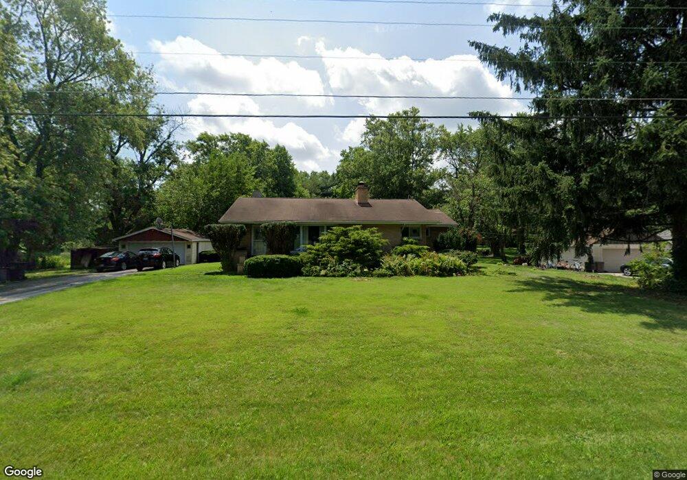
4211 204th St Matteson, IL 60443
Old Matteson NeighborhoodEstimated Value: $227,185 - $242,000
4
Beds
2
Baths
1,435
Sq Ft
$164/Sq Ft
Est. Value
About This Home
This home is located at 4211 204th St, Matteson, IL 60443 and is currently estimated at $235,296, approximately $163 per square foot. 4211 204th St is a home located in Cook County with nearby schools including Illinois School, Arcadia Elementary School, and Indiana Elementary School.
Ownership History
Date
Name
Owned For
Owner Type
Purchase Details
Closed on
Aug 15, 2023
Sold by
Chicago Title Land Trust Company
Bought by
Zimmerman Christopher C and Zimmerman Marcia A
Current Estimated Value
Create a Home Valuation Report for This Property
The Home Valuation Report is an in-depth analysis detailing your home's value as well as a comparison with similar homes in the area
Home Values in the Area
Average Home Value in this Area
Purchase History
| Date | Buyer | Sale Price | Title Company |
|---|---|---|---|
| Zimmerman Christopher C | -- | Chicago Title |
Source: Public Records
Tax History Compared to Growth
Tax History
| Year | Tax Paid | Tax Assessment Tax Assessment Total Assessment is a certain percentage of the fair market value that is determined by local assessors to be the total taxable value of land and additions on the property. | Land | Improvement |
|---|---|---|---|---|
| 2024 | $3,639 | $15,513 | $5,597 | $9,916 |
| 2023 | $3,115 | $15,513 | $5,597 | $9,916 |
| 2022 | $3,115 | $12,386 | $4,478 | $7,908 |
| 2021 | $3,207 | $12,385 | $4,477 | $7,908 |
| 2020 | $3,153 | $12,385 | $4,477 | $7,908 |
| 2019 | $3,313 | $13,274 | $3,358 | $9,916 |
| 2018 | $3,171 | $13,274 | $3,358 | $9,916 |
| 2017 | $3,114 | $13,274 | $3,358 | $9,916 |
| 2016 | $4,787 | $15,216 | $2,238 | $12,978 |
| 2015 | $4,653 | $15,216 | $2,238 | $12,978 |
| 2014 | $4,603 | $15,216 | $2,238 | $12,978 |
| 2013 | $4,901 | $16,900 | $2,238 | $14,662 |
Source: Public Records
Map
Nearby Homes
- 4500 203rd St
- 20340 Crawford Ave
- 153 Treehouse Rd
- 20520 Crawford Ave
- 135 Treehouse Rd
- 722 Kostner Ave
- 4325 Oakwood Ln
- 4228 Applewood Ln
- 4110 Applewood Ln
- 820 School Ave
- 4329 Applewood Ln
- 312 Grafton Place
- 831 Violet Ln
- 820 Exmoor Rd
- 20920 Governors Hwy
- 20001 Arquilla Cir
- 858 Academy Ave
- 20601 Parthenon Way
- 20535 Marathon Ct
- 20534 Arcadian Dr