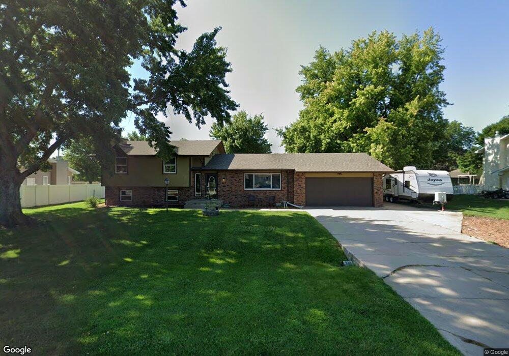
4211 Nordic Rd Grand Island, NE 68803
Estimated Value: $290,878 - $323,000
4
Beds
2
Baths
1,320
Sq Ft
$230/Sq Ft
Est. Value
About This Home
This home is located at 4211 Nordic Rd, Grand Island, NE 68803 and is currently estimated at $303,470, approximately $229 per square foot. 4211 Nordic Rd is a home located in Hall County with nearby schools including Engleman Elementary School, Westridge Middle School, and Grand Island Senior High School.
Ownership History
Date
Name
Owned For
Owner Type
Purchase Details
Closed on
Apr 5, 2016
Sold by
Walters Jad E
Bought by
Burns Paul M and Burns Sierra M
Current Estimated Value
Home Financials for this Owner
Home Financials are based on the most recent Mortgage that was taken out on this home.
Original Mortgage
$153,900
Outstanding Balance
$122,464
Interest Rate
3.73%
Mortgage Type
New Conventional
Estimated Equity
$181,006
Purchase Details
Closed on
Nov 30, 2001
Sold by
Campbell Lyman M and Mary Joanne
Bought by
Walters Vivian J
Create a Home Valuation Report for This Property
The Home Valuation Report is an in-depth analysis detailing your home's value as well as a comparison with similar homes in the area
Home Values in the Area
Average Home Value in this Area
Purchase History
| Date | Buyer | Sale Price | Title Company |
|---|---|---|---|
| Burns Paul M | $162,000 | Advantange Title Services | |
| Walters Vivian J | $107,700 | -- |
Source: Public Records
Mortgage History
| Date | Status | Borrower | Loan Amount |
|---|---|---|---|
| Open | Burns Paul M | $153,900 |
Source: Public Records
Tax History Compared to Growth
Tax History
| Year | Tax Paid | Tax Assessment Tax Assessment Total Assessment is a certain percentage of the fair market value that is determined by local assessors to be the total taxable value of land and additions on the property. | Land | Improvement |
|---|---|---|---|---|
| 2024 | $3,104 | $213,067 | $43,799 | $169,268 |
| 2023 | $3,798 | $209,023 | $43,799 | $165,224 |
| 2022 | $3,294 | $163,915 | $20,060 | $143,855 |
| 2021 | $3,343 | $163,915 | $20,060 | $143,855 |
| 2020 | $3,262 | $163,915 | $20,060 | $143,855 |
| 2019 | $3,286 | $155,897 | $20,060 | $135,837 |
| 2017 | $3,234 | $149,429 | $20,060 | $129,369 |
| 2016 | $3,047 | $146,224 | $20,060 | $126,164 |
| 2015 | $2,781 | $131,437 | $20,060 | $111,377 |
| 2014 | $2,777 | $126,512 | $20,060 | $106,452 |
Source: Public Records
Map
Nearby Homes
- 4204 W Capital Ave
- 2110 Topeka Cir
- 2203 Macron St
- 4019 Sacramento Cir
- 4011 Sacramento Cir
- 4242 Spur Ln
- 4128 Allen Ave
- 4306 Saddle Horse Ct
- 4121 Allen Ave
- 3920 Majestic Ave
- 1429 Mansfield Rd
- 3814 Majestic Ave
- 3804 Norseman Ave
- 1604 Meadow Rd
- 4048 Northview Dr
- 2931 Lee St
- 629 N White
- 4213 Amble Way
- 4223 Amble Way
- 4233 Amble Way