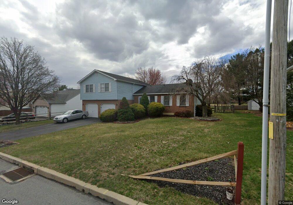
4212 Stoudts Ferry Bridge Rd Reading, PA 19605
Riverview Park NeighborhoodEstimated Value: $325,717 - $387,000
3
Beds
2
Baths
1,944
Sq Ft
$182/Sq Ft
Est. Value
About This Home
This home is located at 4212 Stoudts Ferry Bridge Rd, Reading, PA 19605 and is currently estimated at $354,179, approximately $182 per square foot. 4212 Stoudts Ferry Bridge Rd is a home located in Berks County with nearby schools including C E Cole Intermediate School, Muhlenberg Elementary Center, and Muhlenberg Junior High School.
Ownership History
Date
Name
Owned For
Owner Type
Purchase Details
Closed on
Jun 14, 2010
Sold by
Hoffman Murray L and Hoffman Karen E
Bought by
Hoffman Murray I and Hoffman Karen E
Current Estimated Value
Purchase Details
Closed on
Jul 31, 2001
Sold by
Krotulski Kevin and Krotulski Frances M
Bought by
Hoffman Murray L and Hoffman Karen E
Home Financials for this Owner
Home Financials are based on the most recent Mortgage that was taken out on this home.
Original Mortgage
$116,000
Outstanding Balance
$44,726
Interest Rate
6.99%
Estimated Equity
$309,453
Create a Home Valuation Report for This Property
The Home Valuation Report is an in-depth analysis detailing your home's value as well as a comparison with similar homes in the area
Home Values in the Area
Average Home Value in this Area
Purchase History
| Date | Buyer | Sale Price | Title Company |
|---|---|---|---|
| Hoffman Murray I | -- | None Available | |
| Hoffman Murray L | $145,000 | -- |
Source: Public Records
Mortgage History
| Date | Status | Borrower | Loan Amount |
|---|---|---|---|
| Open | Hoffman Murray L | $116,000 | |
| Closed | Hoffman Murray L | $21,750 |
Source: Public Records
Tax History Compared to Growth
Tax History
| Year | Tax Paid | Tax Assessment Tax Assessment Total Assessment is a certain percentage of the fair market value that is determined by local assessors to be the total taxable value of land and additions on the property. | Land | Improvement |
|---|---|---|---|---|
| 2025 | $1,659 | $110,500 | $26,000 | $84,500 |
| 2024 | $5,320 | $110,500 | $26,000 | $84,500 |
| 2023 | $4,993 | $110,500 | $26,000 | $84,500 |
| 2022 | $4,910 | $110,500 | $26,000 | $84,500 |
| 2021 | $4,794 | $110,500 | $26,000 | $84,500 |
| 2020 | $4,794 | $110,500 | $26,000 | $84,500 |
| 2019 | $4,693 | $110,500 | $26,000 | $84,500 |
| 2018 | $4,610 | $110,500 | $26,000 | $84,500 |
| 2017 | $4,523 | $110,500 | $26,000 | $84,500 |
| 2016 | $1,340 | $110,500 | $26,000 | $84,500 |
| 2015 | $1,340 | $110,500 | $26,000 | $84,500 |
| 2014 | $1,340 | $110,500 | $26,000 | $84,500 |
Source: Public Records
Map
Nearby Homes
- 1052 Boeshore Cir
- 914 Suellen Dr
- 1012 Dallas Rd
- 1282 Fredrick Blvd Unit 15F
- 1105 Showers Ln
- 833 Pine Heights Rd
- 1033 Whitford Dr
- 3706 Rosewood Rd
- 1125 Ashbourne Dr
- 1129 Whitner Rd
- 1025 River Crest Dr
- 1072 Grandell Ave
- 1033 Barberry Ave
- 1019 Heath Ave
- 1021 Barberry Ave Unit T67
- 1002 Heath Ave
- 3500 Eisenbrown Rd
- 1047 Sage Ave
- 1162 Tuckerton Rd
- 5213 Stoudts Ferry Bridge Rd
- 4216 Stoudts Ferry Bridge Rd
- 4208 Stoudts Ferry Bridge Rd
- 0 Stoudts Ferry Bridge Rd Unit 5880601
- 0 Stoudts Ferry Bridge Rd Unit 6226368
- 0 Stoudts Ferry Bridge Rd Unit 6445659
- 0 Stoudts Ferry Bridge Rd Unit PABK2045992
- 0 Stoudts Ferry Bridge Rd Unit PABK2046286
- 0 Stoudts Ferry Bridge Rd Unit PABK2046042
- 0 Stoudts Ferry Bridge Rd Unit PABK2046030
- 0 Stoudts Ferry Bridge Rd Unit PABK2046288
- 0 Stoudts Ferry Bridge Rd Unit PABK2000366
- 0 Stoudts Ferry Bridge Rd Unit 1003896261
- 4220 Stoudts Ferry Bridge Rd
- 4204 Stoudts Ferry Bridge Rd
- 801 Allen Ave
- 805 Allen Ave
- 4224 Stoudts Ferry Bridge Rd
- 813 Allen Ave
- 800 Allen Ave
- 817 Allen Ave