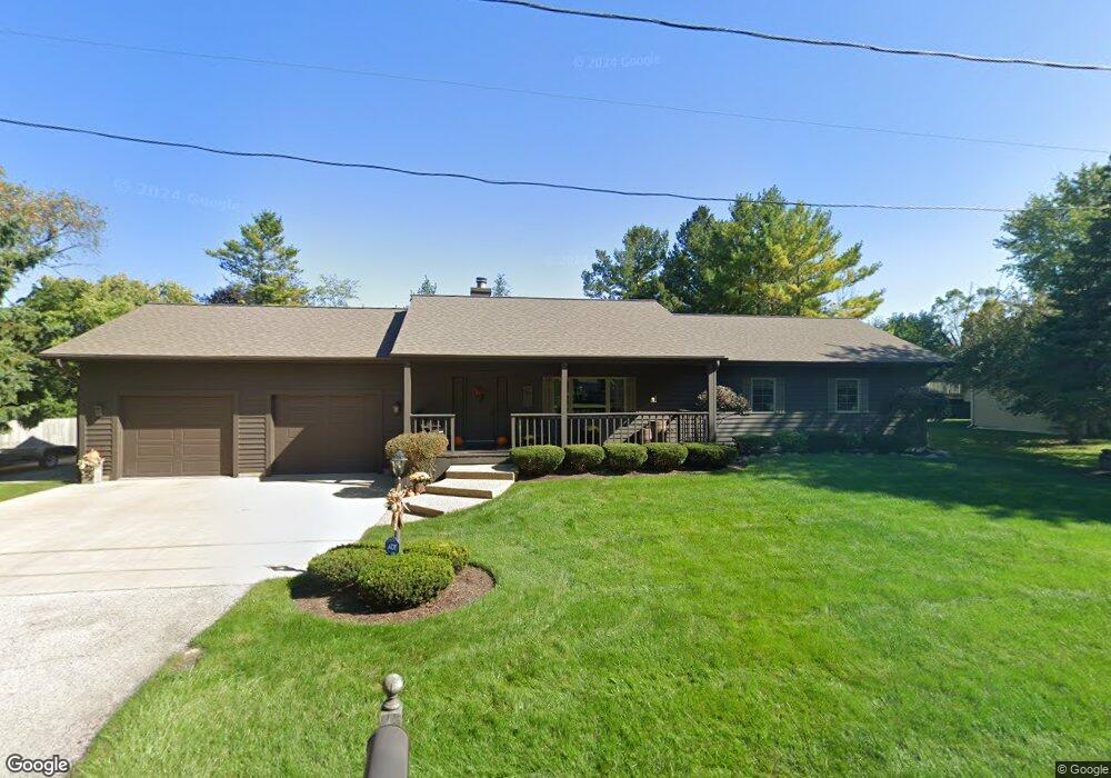
42177 N Fossland Ave Zion, IL 60099
Shore Acres NeighborhoodEstimated Value: $318,000 - $378,000
3
Beds
2
Baths
1,740
Sq Ft
$195/Sq Ft
Est. Value
About This Home
This home is located at 42177 N Fossland Ave, Zion, IL 60099 and is currently estimated at $339,791, approximately $195 per square foot. 42177 N Fossland Ave is a home located in Lake County with nearby schools including Kenneth Murphy School, Beach Park Middle School, and Zion-Benton Township High School.
Ownership History
Date
Name
Owned For
Owner Type
Purchase Details
Closed on
Jan 18, 2009
Sold by
Nikkila William J and Nikkila Tina D
Bought by
Nikkila William J and Nikkila Tina D
Current Estimated Value
Purchase Details
Closed on
Dec 12, 1995
Sold by
Nikkila William J
Bought by
Nikkila William J and Nikkila Tina D
Home Financials for this Owner
Home Financials are based on the most recent Mortgage that was taken out on this home.
Original Mortgage
$146,000
Interest Rate
7.41%
Create a Home Valuation Report for This Property
The Home Valuation Report is an in-depth analysis detailing your home's value as well as a comparison with similar homes in the area
Home Values in the Area
Average Home Value in this Area
Purchase History
| Date | Buyer | Sale Price | Title Company |
|---|---|---|---|
| Nikkila William J | -- | None Available | |
| Nikkila William J | -- | Lawyers Title Insurance Corp |
Source: Public Records
Mortgage History
| Date | Status | Borrower | Loan Amount |
|---|---|---|---|
| Closed | Nikkila William J | $146,000 |
Source: Public Records
Tax History Compared to Growth
Tax History
| Year | Tax Paid | Tax Assessment Tax Assessment Total Assessment is a certain percentage of the fair market value that is determined by local assessors to be the total taxable value of land and additions on the property. | Land | Improvement |
|---|---|---|---|---|
| 2024 | $7,217 | $102,787 | $9,944 | $92,843 |
| 2023 | $7,529 | $89,625 | $9,599 | $80,026 |
| 2022 | $7,529 | $81,583 | $9,396 | $72,187 |
| 2021 | $7,342 | $75,526 | $9,157 | $66,369 |
| 2020 | $7,176 | $72,073 | $8,738 | $63,335 |
| 2019 | $7,164 | $68,380 | $8,290 | $60,090 |
| 2018 | $7,643 | $70,215 | $9,995 | $60,220 |
| 2017 | $7,583 | $66,054 | $9,403 | $56,651 |
| 2016 | $7,380 | $62,885 | $8,952 | $53,933 |
| 2015 | $7,150 | $57,672 | $8,210 | $49,462 |
| 2014 | $6,337 | $54,931 | $6,792 | $48,139 |
| 2012 | $6,388 | $57,083 | $7,058 | $50,025 |
Source: Public Records
Map
Nearby Homes
- 1405 Lewis Ave
- 1531 Southport Ct
- 1304 Pelican Ct
- 1521 Southport Ct
- 3616 Creekside Ct
- 3707 Willow Crest Dr
- 3717 Willow Crest Dr
- 42908 N Lewis Ave
- 3106 13th St
- 1703 Hermon Ave
- 0 9th St
- 4014 Ridge Rd
- 1417 Westside Trail
- 1817 Joppa Ave
- 1701 Galilee Ave
- 1814 Jethro Ave
- 1807 Horeb Ave
- 1302 Lorelei Dr
- 43100 N Lewis Ave
- 429 Megan Place
- 42163 N Fossland Ave
- 42162 N Fossland Ave
- 42145 N Fossland Ave
- 11547 W 11th St
- 11589 W 11th St
- 42144 N Fossland Ave
- 42177 N Fago Ave
- 42163 N Fago Ave
- 42215 N Fago Ave
- 42145 N Fago Ave
- 11623 W 11th St
- 11588 W 11th St
- 42176 N Fago Ave
- 11622 W 11th St
- 42162 N Fago Ave
- 42281 N Fossland Ave
- 3113 12th St
- 42263 Lewis Ave
- 42280 Lewis Ave