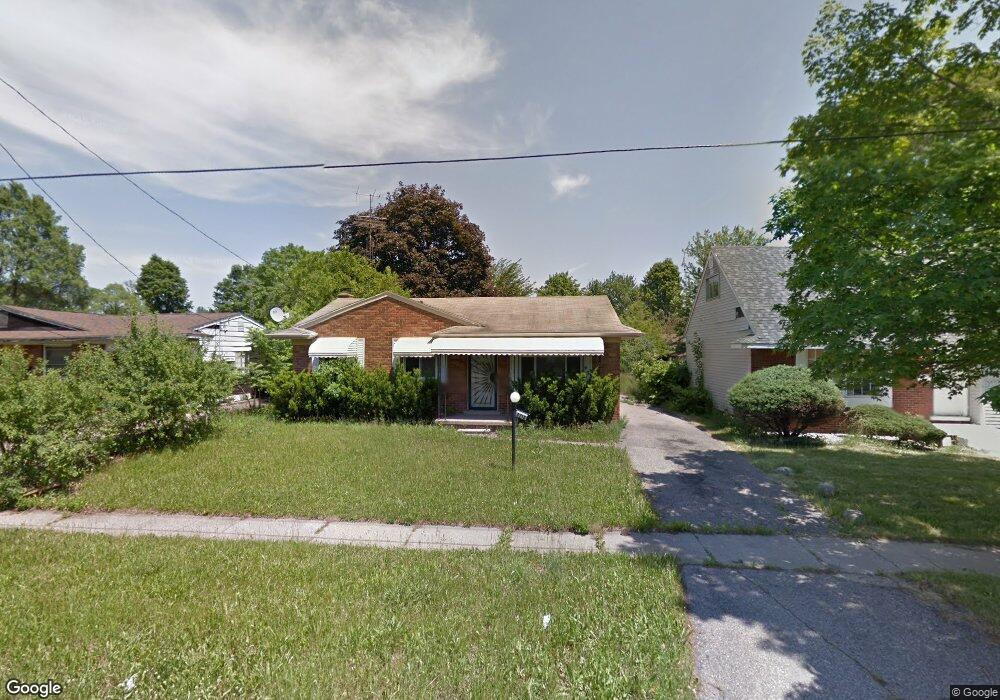
4218 Leerda St Flint, MI 48504
Merill NeighborhoodEstimated Value: $39,000 - $67,000
3
Beds
1
Bath
995
Sq Ft
$51/Sq Ft
Est. Value
About This Home
This home is located at 4218 Leerda St, Flint, MI 48504 and is currently estimated at $50,712, approximately $50 per square foot. 4218 Leerda St is a home located in Genesee County with nearby schools including Brownell STEM Academy, The New Standard Academy, and Eagle's Nest Academy.
Ownership History
Date
Name
Owned For
Owner Type
Purchase Details
Closed on
Nov 23, 2010
Sold by
Hicks Kathy
Bought by
Grace Emmanuel Baptist Church
Current Estimated Value
Purchase Details
Closed on
Aug 2, 2006
Sold by
Mitchell Barry and Mitchell Grace A
Bought by
Lasalle Bank Na and Structured Asset Securities Corp
Purchase Details
Closed on
Jan 8, 2003
Sold by
Mitchell Rolonda
Bought by
Mitchell Barry
Purchase Details
Closed on
Oct 14, 1998
Sold by
Rush Fredia and Scott Yuronda
Bought by
Mitchell Rolonda
Purchase Details
Closed on
Oct 8, 1998
Sold by
Estate Of Freddie Scott
Bought by
Mitchell Rolonda and Scott Yuronda
Create a Home Valuation Report for This Property
The Home Valuation Report is an in-depth analysis detailing your home's value as well as a comparison with similar homes in the area
Home Values in the Area
Average Home Value in this Area
Purchase History
| Date | Buyer | Sale Price | Title Company |
|---|---|---|---|
| Grace Emmanuel Baptist Church | $3,000 | Parks Title | |
| Lasalle Bank Na | $41,769 | None Available | |
| Mitchell Barry | $35,000 | Titlequest Agency | |
| Mitchell Rolonda | -- | -- | |
| Mitchell Rolonda | -- | -- |
Source: Public Records
Tax History Compared to Growth
Tax History
| Year | Tax Paid | Tax Assessment Tax Assessment Total Assessment is a certain percentage of the fair market value that is determined by local assessors to be the total taxable value of land and additions on the property. | Land | Improvement |
|---|---|---|---|---|
| 2025 | $932 | $16,400 | $0 | $0 |
| 2024 | $868 | $14,700 | $0 | $0 |
| 2023 | $852 | $11,200 | $0 | $0 |
| 2022 | $0 | $8,600 | $0 | $0 |
| 2021 | $862 | $8,200 | $0 | $0 |
| 2020 | $857 | $9,000 | $0 | $0 |
| 2019 | $1,624 | $10,400 | $0 | $0 |
| 2018 | $1,073 | $12,200 | $0 | $0 |
| 2017 | $1,334 | $0 | $0 | $0 |
| 2016 | $1,199 | $0 | $0 | $0 |
| 2015 | -- | $0 | $0 | $0 |
| 2014 | -- | $0 | $0 | $0 |
| 2012 | -- | $17,600 | $0 | $0 |
Source: Public Records
Map
Nearby Homes
- 4201 Winona St
- 2118 Santa Barbara Dr
- 3819 Brownell Blvd
- 1913 Cherrylawn Dr
- 3722 Sterling St
- 3617 Kellar Ave
- 1621 Shamrock Ln
- 3420 Fleming Rd
- 3412 Comstock Ave
- 4006 Donnelly St
- 3802 Milbourne Ave
- 3330 Maywood Dr
- 4515 Baldwin Blvd
- 1705 W Pasadena Ave
- 5106 Cloverlawn Dr
- 3513 Milbourne Ave
- 4808 Edwards Ave
- 5302 Susan St
- 606 W Stewart Ave
- 3084 Roanoke St
- 4214 Leerda St
- 4222 Leerda St
- 4226 Leerda St
- 4210 Leerda St
- 4221 Trumbull Ave
- 4213 Trumbull Ave
- 4217 Trumbull Ave
- 4217 Leerda St
- 4221 Leerda St
- 4213 Leerda St
- 4225 Leerda St
- 4209 Leerda St
- 4229 Trumbull Ave
- 4202 Leerda St
- 4234 Leerda St
- 4229 Leerda St
- 4233 Leerda St
- 4205 Leerda St
- 4218 Trumbull Ave
- 4201 Leerda St