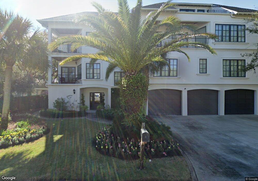
4219 12th St Saint Simons Island, GA 31522
Estimated Value: $3,089,530 - $4,218,000
7
Beds
9
Baths
6,000
Sq Ft
$612/Sq Ft
Est. Value
About This Home
This home is located at 4219 12th St, Saint Simons Island, GA 31522 and is currently estimated at $3,671,133, approximately $611 per square foot. 4219 12th St is a home located in Glynn County with nearby schools including St. Simons Elementary School, Glynn Middle School, and Glynn Academy.
Ownership History
Date
Name
Owned For
Owner Type
Purchase Details
Closed on
Apr 13, 2024
Sold by
Patton Cornealia Ham
Bought by
Patton Cornealia Ham Trust and Patton Robert Covington Tr
Current Estimated Value
Purchase Details
Closed on
Apr 20, 2023
Sold by
Patton Robert Covington
Bought by
Patton Cornealia Ham and Robert Covington Pattion 2023 Family Tru
Purchase Details
Closed on
Dec 12, 2021
Sold by
Patton Robert C
Bought by
Patton Cornealia Ham
Purchase Details
Closed on
Oct 8, 2012
Sold by
Patton Cornealia H
Bought by
Patton Robert C
Purchase Details
Closed on
Oct 28, 2011
Sold by
Branch Banking & Trust Company
Bought by
Patton Robert C and Patton Cornelia H
Purchase Details
Closed on
May 3, 2011
Sold by
Mts Properties Llc
Bought by
Branch Banking & Trust Company
Purchase Details
Closed on
Apr 11, 2008
Sold by
Saari Paul G
Bought by
Mts Properties Llc
Purchase Details
Closed on
Apr 18, 2005
Sold by
Walker Ruth Gray
Bought by
Saari Paul G
Create a Home Valuation Report for This Property
The Home Valuation Report is an in-depth analysis detailing your home's value as well as a comparison with similar homes in the area
Home Values in the Area
Average Home Value in this Area
Purchase History
| Date | Buyer | Sale Price | Title Company |
|---|---|---|---|
| Patton Cornealia Ham Trust | -- | -- | |
| Patton Robert Covington Trust | -- | -- | |
| Patton Cornealia Ham | -- | -- | |
| Patton Cornealia Ham | $1,789,200 | -- | |
| Patton Robert C | -- | -- | |
| Patton Robert C | $1,600,000 | -- | |
| Branch Banking & Trust Company | -- | -- | |
| Mts Properties Llc | -- | -- | |
| Saari Paul G | -- | -- | |
| Saari Paul G | $890,000 | -- |
Source: Public Records
Tax History Compared to Growth
Tax History
| Year | Tax Paid | Tax Assessment Tax Assessment Total Assessment is a certain percentage of the fair market value that is determined by local assessors to be the total taxable value of land and additions on the property. | Land | Improvement |
|---|---|---|---|---|
| 2025 | $27,963 | $1,115,000 | $401,400 | $713,600 |
| 2024 | $27,963 | $1,115,000 | $401,400 | $713,600 |
| 2023 | $33,236 | $1,347,400 | $482,480 | $864,920 |
| 2022 | $27,411 | $1,088,000 | $307,040 | $780,960 |
| 2021 | $18,632 | $715,680 | $307,040 | $408,640 |
| 2020 | $18,811 | $715,680 | $307,040 | $408,640 |
| 2019 | $15,770 | $715,680 | $307,040 | $408,640 |
| 2018 | $18,680 | $715,680 | $307,040 | $408,640 |
| 2017 | $15,902 | $604,240 | $175,440 | $428,800 |
| 2016 | $14,627 | $604,240 | $175,440 | $428,800 |
| 2015 | $14,687 | $604,240 | $175,440 | $428,800 |
| 2014 | $14,687 | $604,240 | $175,440 | $428,800 |
Source: Public Records
Map
Nearby Homes
- 2022 Bruce Cir
- 4318 13th St
- 1909 Dixon Ln
- 4318 7th St
- 1709 Dixon Ln
- 1626 Bruce Dr
- 1604 Bruce Dr
- 6 Coast Cottage Ln
- 17 Sea Oats Ln
- 5 and 7 Sea Oats Ln
- 1528 Ocean Blvd
- 1524 Wood Ave Unit 303
- 1524 Wood Ave Unit 215
- 1524 Wood Ave Unit 214
- 1524 Wood Ave Unit 314
- 1524 Wood Ave Unit 116
- 1495 Wood Ave
- 1460 Ocean Blvd Unit 101
- 1440 Ocean Blvd Unit 420
- 1440 Ocean Blvd Unit 437