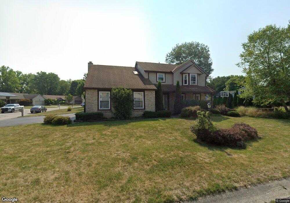
422 White Path St Pataskala, OH 43062
Estimated Value: $366,530 - $399,000
4
Beds
3
Baths
2,114
Sq Ft
$182/Sq Ft
Est. Value
About This Home
This home is located at 422 White Path St, Pataskala, OH 43062 and is currently estimated at $383,883, approximately $181 per square foot. 422 White Path St is a home located in Licking County with nearby schools including Pataskala Elementary School, Etna Elementary School, and Watkins Middle School.
Ownership History
Date
Name
Owned For
Owner Type
Purchase Details
Closed on
Nov 18, 2002
Sold by
Bias Melba
Bought by
Cisar Michael and Cisar Patricia
Current Estimated Value
Home Financials for this Owner
Home Financials are based on the most recent Mortgage that was taken out on this home.
Original Mortgage
$130,000
Outstanding Balance
$54,772
Interest Rate
6.1%
Mortgage Type
New Conventional
Estimated Equity
$329,111
Create a Home Valuation Report for This Property
The Home Valuation Report is an in-depth analysis detailing your home's value as well as a comparison with similar homes in the area
Home Values in the Area
Average Home Value in this Area
Purchase History
| Date | Buyer | Sale Price | Title Company |
|---|---|---|---|
| Cisar Michael | $162,700 | -- |
Source: Public Records
Mortgage History
| Date | Status | Borrower | Loan Amount |
|---|---|---|---|
| Open | Cisar Michael | $130,000 |
Source: Public Records
Tax History
| Year | Tax Paid | Tax Assessment Tax Assessment Total Assessment is a certain percentage of the fair market value that is determined by local assessors to be the total taxable value of land and additions on the property. | Land | Improvement |
|---|---|---|---|---|
| 2024 | $4,705 | $113,230 | $25,450 | $87,780 |
| 2023 | $4,701 | $113,230 | $25,450 | $87,780 |
| 2022 | $3,876 | $79,870 | $17,150 | $62,720 |
| 2021 | $3,992 | $79,870 | $17,150 | $62,720 |
| 2020 | $4,053 | $79,870 | $17,150 | $62,720 |
| 2019 | $3,571 | $64,970 | $12,710 | $52,260 |
| 2018 | $3,583 | $0 | $0 | $0 |
| 2017 | $3,140 | $0 | $0 | $0 |
| 2016 | $2,832 | $0 | $0 | $0 |
| 2015 | $2,729 | $0 | $0 | $0 |
| 2014 | $3,473 | $0 | $0 | $0 |
| 2013 | $2,953 | $0 | $0 | $0 |
Source: Public Records
Map
Nearby Homes
- 388 S Township Rd
- 116 Ruby Rd
- 145 Shawnee Loop N
- 81 Town St
- 402 Shawnee Loop S
- 0 Blacks Rd Unit 215031989
- 0 Blacks Rd Unit Lot 10
- 263 International Dr
- 303 Levi Dr Unit Lot 7
- 186 Markway Dr Unit Lot 12
- 188 Markway Dr Unit Lot 13
- 0 E Broad St
- 456 Joseph van Dorn Ct
- 0 Hazelton-Etna Rd SW Unit 224002323
- 308 Reign Way
- 306 Reign Way
- 309 Reign Way
- 302 Reign Way
- 314 Reign Way
- 839 Corylus Dr SW
- 215 S Fork Cir
- 428 White Path St
- 425 White Path St
- 209 S Fork Cir
- 419 White Path St
- 434 White Path St
- 431 White Path St
- 410 White Path St
- 203 S Fork Cir
- 413 White Path St
- 218 S Fork Cir
- 437 White Path St
- 197 S Fork Cir
- 216 S Fork Cir
- 442 White Path St
- 407 White Path St
- 428 Township Rd
- 420 Township Rd
- 443 White Path St
- 191 S Fork Cir
Your Personal Tour Guide
Ask me questions while you tour the home.