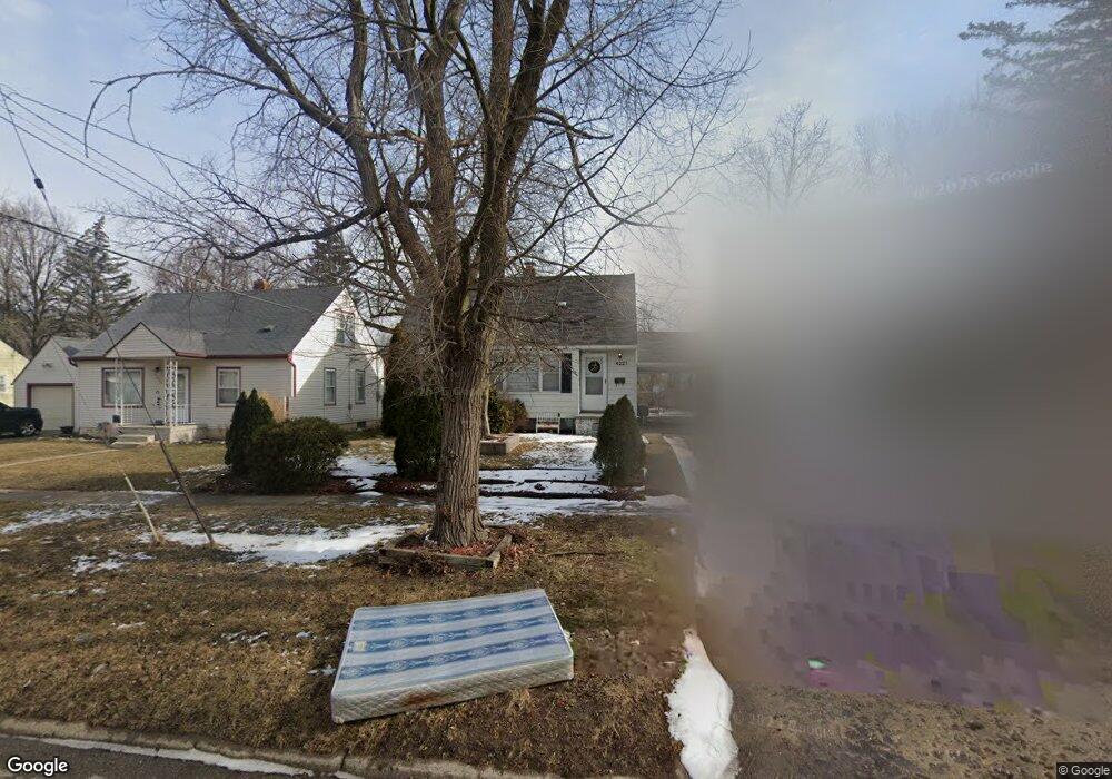
4221 Circle Dr Flint, MI 48507
Circle Drive NeighborhoodEstimated Value: $65,572 - $77,000
3
Beds
1
Bath
1,046
Sq Ft
$68/Sq Ft
Est. Value
About This Home
This home is located at 4221 Circle Dr, Flint, MI 48507 and is currently estimated at $71,643, approximately $68 per square foot. 4221 Circle Dr is a home located in Genesee County with nearby schools including Freeman Elementary School, Flint Southwestern Classical Academy, and International Academy of Flint (K-12).
Ownership History
Date
Name
Owned For
Owner Type
Purchase Details
Closed on
Nov 13, 2014
Sold by
Wier Charlotte
Bought by
Wier Charlotte and Wier Amanda Sue
Current Estimated Value
Purchase Details
Closed on
Jun 24, 2011
Sold by
Flynn Paul P and Flynn Sarah E
Bought by
Wier Charlotte
Purchase Details
Closed on
Feb 14, 2002
Sold by
Bailey Gary J and Bailey Cheryl
Bought by
Flynn Paul P and Flynn Sarah E
Create a Home Valuation Report for This Property
The Home Valuation Report is an in-depth analysis detailing your home's value as well as a comparison with similar homes in the area
Home Values in the Area
Average Home Value in this Area
Purchase History
We collect this data history from publicly available records. To have your information removed, we recommend requesting removal directly through your county’s website.
| Date | Buyer | Sale Price | Title Company |
|---|---|---|---|
| Wier Charlotte | -- | None Available | |
| Wier Charlotte | $25,000 | Sargents Title Company | |
| Flynn Paul P | $69,900 | Sargents Title Company |
Source: Public Records
Tax History
| Year | Tax Paid | Tax Assessment Tax Assessment Total Assessment is a certain percentage of the fair market value that is determined by local assessors to be the total taxable value of land and additions on the property. | Land | Improvement |
|---|---|---|---|---|
| 2025 | $920 | $31,000 | $0 | $0 |
| 2024 | $835 | $27,300 | $0 | $0 |
| 2023 | $822 | $24,200 | $0 | $0 |
| 2022 | $0 | $19,500 | $0 | $0 |
| 2021 | $853 | $18,100 | $0 | $0 |
| 2020 | $772 | $14,600 | $0 | $0 |
| 2019 | $753 | $11,200 | $0 | $0 |
| 2018 | $1,336 | $10,200 | $0 | $0 |
| 2017 | $774 | $0 | $0 | $0 |
| 2016 | $769 | $0 | $0 | $0 |
| 2015 | -- | $0 | $0 | $0 |
| 2014 | -- | $0 | $0 | $0 |
| 2012 | -- | $14,600 | $0 | $0 |
Source: Public Records
Map
Nearby Homes
- 4126 Circle Dr
- 617 McKeighan Ave
- 621 Burroughs Ave
- 4234 Custer Ave
- 4127 Custer Ave
- 813 McKeighan Ave
- 4533 Pengelly Rd
- 420 Burroughs Ave
- 454 E Atherton Rd
- 4301 Pengelly Rd
- 413 E Hemphill Rd
- 1005 Macdonald Ave
- 352 Buckingham Ave
- 4424 Cheyenne Ave
- 720 Algonquin Ave
- 701 Algonquin Ave
- 3290 Cheyenne Ave
- 3505 Comanche Ave
- 3317 Cheyenne Ave
- 3224 Circle Dr
- 4231 Circle Dr
- 4213 Circle Dr
- 602 Mckinley Ave
- 607 Lochhead Ave
- 608 Mckinley Ave
- 4201 Circle Dr
- 612 Mckinley Ave
- 4226 Circle Dr
- 4230 Circle Dr
- 616 Mckinley Ave
- 617 Lochhead Ave
- 4302 Circle Dr
- 4306 Circle Dr
- 4218 Circle Dr
- 4310 Circle Dr
- 4301 Circle Dr
- 4214 Circle Dr
- 624 Mckinley Ave
- 601 Mckinley Ave
- 519 Mckinley Ave
Your Personal Tour Guide
Ask me questions while you tour the home.