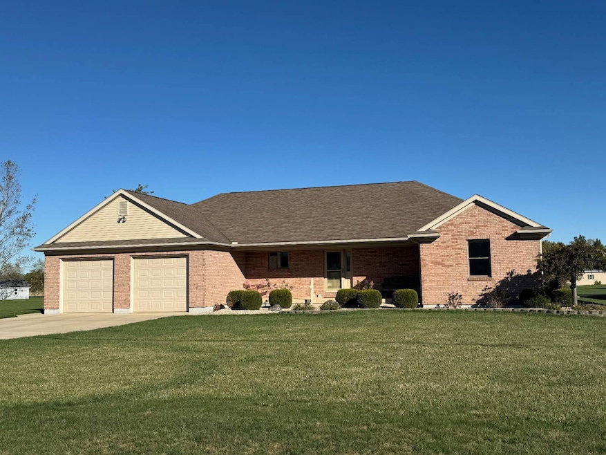
4221 State Route 362 Fort Loramie, OH 45845
Estimated payment $3,432/month
Total Views
2,901
3
Beds
2.5
Baths
2,008
Sq Ft
$284
Price per Sq Ft
Highlights
- 3 Car Attached Garage
- Patio
- Zoned Heating and Cooling System
- Fort Loramie Elementary School Rated A
- Shed
- 1-Story Property
About This Home
Home to include dishwasher, microwave, all existing window coverings, water softener and 12'x16' storage shed. Private well, central sewer, and full bath "rough in" in basement floor for future bath.
Home Details
Home Type
- Single Family
Year Built
- Built in 2010
Lot Details
- 0.76 Acre Lot
Parking
- 3 Car Attached Garage
Home Design
- Brick Exterior Construction
- Frame Construction
- Asphalt Roof
Interior Spaces
- 2,008 Sq Ft Home
- 1-Story Property
- Unfinished Basement
- Basement Fills Entire Space Under The House
Kitchen
- Microwave
- Dishwasher
Bedrooms and Bathrooms
- 3 Bedrooms
Outdoor Features
- Patio
- Shed
Utilities
- Zoned Heating and Cooling System
- Heat Pump System
- Septic Tank
Map
Create a Home Valuation Report for This Property
The Home Valuation Report is an in-depth analysis detailing your home's value as well as a comparison with similar homes in the area
Home Values in the Area
Average Home Value in this Area
Tax History
| Year | Tax Paid | Tax Assessment Tax Assessment Total Assessment is a certain percentage of the fair market value that is determined by local assessors to be the total taxable value of land and additions on the property. | Land | Improvement |
|---|---|---|---|---|
| 2024 | $5,224 | $151,690 | $8,740 | $142,950 |
| 2023 | $5,224 | $151,690 | $8,740 | $142,950 |
| 2022 | $4,307 | $115,450 | $7,100 | $108,350 |
| 2021 | $4,353 | $115,450 | $7,100 | $108,350 |
| 2020 | $4,352 | $115,450 | $7,100 | $108,350 |
| 2019 | $3,693 | $98,770 | $5,900 | $92,870 |
| 2018 | $3,603 | $98,770 | $5,900 | $92,870 |
| 2017 | $3,612 | $98,290 | $5,900 | $92,390 |
| 2016 | $3,248 | $86,700 | $4,910 | $81,790 |
| 2015 | $3,227 | $86,900 | $4,910 | $81,990 |
| 2014 | $3,227 | $86,900 | $4,910 | $81,990 |
| 2013 | $3,486 | $86,900 | $4,910 | $81,990 |
Source: Public Records
Property History
| Date | Event | Price | List to Sale | Price per Sq Ft |
|---|---|---|---|---|
| 10/31/2025 10/31/25 | For Sale | $569,900 | -- | $284 / Sq Ft |
Source: My State MLS
Purchase History
| Date | Type | Sale Price | Title Company |
|---|---|---|---|
| Warranty Deed | $30,000 | Attorney |
Source: Public Records
Mortgage History
| Date | Status | Loan Amount | Loan Type |
|---|---|---|---|
| Open | $200,600 | Construction |
Source: Public Records
Source: My State MLS
MLS Number: 11599283
APN: 30-07-12-300-017
Nearby Homes
- 10 W Main St
- 8381 Ohio 66
- 12299 Short Dr
- 7 E 2nd St
- 194 S Cleveland St
- 193 N Paris St
- 47 N Frankfort St
- 0 Stonegate Dr Unit 14 10544847
- 0 Stonegate Dr Unit 21 10544857
- 17 Stonegate Dr
- 11 Shania Place Unit 28
- 36 Shania Place Unit 23
- 28 Shania Place Unit 33
- 19 Shania Place Unit 33
- 27 Shania Place Unit 26
- 11968 Arling Rd
- 561 S Walnut St Unit Lot3
- 149 Janice Dr
- 157 Janice Dr
- 153 Janice Dr
- 7772 Huwer Rd
- 2150 Echo Dr
- 776 Country
- 610 N Wagner Ave
- 276 W Pinehurst St
- 2365 Collins Dr Unit C
- 2355 Collins Dr Unit A
- 1184 Huron Ct
- 1520 Spruce Ave Unit 10
- 121 W Poplar St
- 113 N Ohio Ave
- 110 N Ohio Ave
- 5711 Reier Rd
- 416 Beech St
- 800 Indiana Ave
- 2200 Deerfield Crossing Unit 2222
- 1002 Park Ave
- 1016 Eleanor Ave Unit 1016
- 316 N College St
- 90 Maryville Ln
