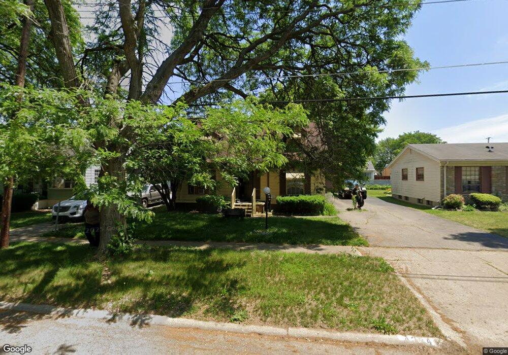
4224 Comstock Ave Flint, MI 48504
Merill NeighborhoodEstimated Value: $45,000 - $76,000
3
Beds
2
Baths
1,338
Sq Ft
$46/Sq Ft
Est. Value
About This Home
This home is located at 4224 Comstock Ave, Flint, MI 48504 and is currently estimated at $61,720, approximately $46 per square foot. 4224 Comstock Ave is a home located in Genesee County with nearby schools including Brownell STEM Academy, The New Standard Academy, and Eagle's Nest Academy.
Ownership History
Date
Name
Owned For
Owner Type
Purchase Details
Closed on
Jun 28, 2021
Sold by
Genesee County Land Bank
Bought by
Patrick Larosra
Current Estimated Value
Purchase Details
Closed on
Jan 17, 2017
Sold by
The Genesee County Land Bank Authority
Bought by
Patrick Larosa
Purchase Details
Closed on
Dec 20, 2016
Sold by
Cherry Deborah L
Bought by
Genesse County Land Bank
Create a Home Valuation Report for This Property
The Home Valuation Report is an in-depth analysis detailing your home's value as well as a comparison with similar homes in the area
Home Values in the Area
Average Home Value in this Area
Purchase History
| Date | Buyer | Sale Price | Title Company |
|---|---|---|---|
| Patrick Larosra | $6,500 | None Listed On Document | |
| Patrick Larosa | $6,500 | None Available | |
| Genesse County Land Bank | -- | None Available |
Source: Public Records
Mortgage History
| Date | Status | Borrower | Loan Amount |
|---|---|---|---|
| Closed | Patrick Larosa | $0 |
Source: Public Records
Tax History
| Year | Tax Paid | Tax Assessment Tax Assessment Total Assessment is a certain percentage of the fair market value that is determined by local assessors to be the total taxable value of land and additions on the property. | Land | Improvement |
|---|---|---|---|---|
| 2025 | $890 | $20,700 | $0 | $0 |
| 2024 | $809 | $18,600 | $0 | $0 |
| 2023 | $797 | $14,200 | $0 | $0 |
| 2022 | $0 | $10,800 | $0 | $0 |
| 2021 | $826 | $10,300 | $0 | $0 |
| 2020 | $808 | $11,400 | $0 | $0 |
| 2019 | $1,012 | $11,200 | $0 | $0 |
| 2018 | $1,633 | $13,100 | $0 | $0 |
| 2017 | $549 | $0 | $0 | $0 |
| 2016 | $882 | $0 | $0 | $0 |
| 2015 | -- | $0 | $0 | $0 |
| 2014 | -- | $0 | $0 | $0 |
| 2012 | -- | $17,700 | $0 | $0 |
Source: Public Records
Map
Nearby Homes
- 4539 Trumbull Dr
- 2013 Canniff St
- 3808 Comstock Ave
- 4306 Berger Dr
- 1315 W Myrtle Ave
- 1909 Cherrylawn Dr
- 3710 Kellar Ave
- 3517 Leerda St
- 3722 Sterling St
- 3617 Kellar Ave
- 3505 Leerda St
- 3506 Brownell Blvd
- 3419 Leerda St
- 3413 Leerda St
- 3420 Fleming Rd
- 3802 Milbourne Ave
- 3218 Trumbull Ave
- 3095 Maywood Dr
- 3221 Burgess St
- 4808 Edwards Ave
- 4230 Comstock Ave
- 4218 Comstock Ave
- 4225 Leerda St
- 4221 Leerda St
- 4236 Comstock Ave
- 4212 Comstock Ave
- 4229 Leerda St
- 4217 Leerda St
- 4229 Comstock Ave
- 4233 Leerda St
- 4223 Comstock Ave
- 4213 Leerda St
- 4208 Comstock Ave
- 4217 Comstock Ave
- 4209 Leerda St
- 4211 Comstock Ave
- 4202 Comstock Ave
- 4207 Comstock Ave
- 4226 Leerda St
- 4222 Leerda St
Your Personal Tour Guide
Ask me questions while you tour the home.