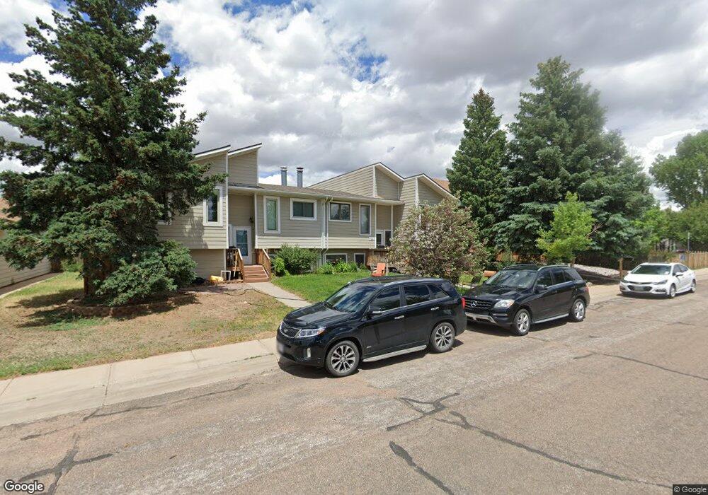
4225 Comanche Dr Laramie, WY 82072
Estimated Value: $285,000 - $352,000
4
Beds
2
Baths
1,040
Sq Ft
$296/Sq Ft
Est. Value
About This Home
This home is located at 4225 Comanche Dr, Laramie, WY 82072 and is currently estimated at $307,387, approximately $295 per square foot. 4225 Comanche Dr is a home located in Albany County with nearby schools including Indian Paintbrush Elementary School, Laramie Junior High School, and Laramie High School.
Ownership History
Date
Name
Owned For
Owner Type
Purchase Details
Closed on
Apr 25, 2024
Sold by
Miller Todd R and Poulson Kira A
Bought by
Tk307 Trust and Miller
Current Estimated Value
Purchase Details
Closed on
May 31, 2012
Sold by
Covello Paul A and Covello Jeri M
Bought by
Poulson Kira A
Home Financials for this Owner
Home Financials are based on the most recent Mortgage that was taken out on this home.
Original Mortgage
$140,000
Interest Rate
3.93%
Mortgage Type
Commercial
Create a Home Valuation Report for This Property
The Home Valuation Report is an in-depth analysis detailing your home's value as well as a comparison with similar homes in the area
Home Values in the Area
Average Home Value in this Area
Purchase History
Date | Buyer | Sale Price | Title Company |
---|---|---|---|
Tk307 Trust | -- | None Listed On Document | |
Poulson Kira A | -- | None Available |
Source: Public Records
Mortgage History
Date | Status | Borrower | Loan Amount |
---|---|---|---|
Previous Owner | Miller Todd R | $118,500 | |
Previous Owner | Poulson Kira A | $140,000 |
Source: Public Records
Tax History Compared to Growth
Tax History
Year | Tax Paid | Tax Assessment Tax Assessment Total Assessment is a certain percentage of the fair market value that is determined by local assessors to be the total taxable value of land and additions on the property. | Land | Improvement |
---|---|---|---|---|
2024 | $1,985 | $27,190 | $4,050 | $23,140 |
2023 | $1,920 | $26,300 | $4,050 | $22,250 |
2022 | $1,749 | $23,953 | $4,452 | $19,501 |
2021 | $1,601 | $21,938 | $3,204 | $18,734 |
2020 | $1,349 | $18,482 | $3,035 | $15,447 |
2019 | $1,354 | $18,545 | $3,035 | $15,510 |
2018 | $1,304 | $17,862 | $2,884 | $14,978 |
2017 | $1,212 | $16,607 | $2,884 | $13,723 |
2016 | $1,235 | $16,916 | $2,884 | $14,032 |
2015 | $1,165 | $15,963 | $2,884 | $13,079 |
2014 | $1,107 | $15,170 | $0 | $0 |
Source: Public Records
Map
Nearby Homes
- 4311 Comanche Dr
- 4316 Cheyenne Dr
- 1050 N Indian Hills Dr
- 4222 E Grays Gable Rd
- 4407 Cheyenne Dr
- 4106 Kiowa Dr
- 4420 E Grays Gable Rd
- 1668 N Indian Hills Dr
- 3734 Reynolds St
- 1651 Fox Ridge Rd
- TBD Hayford Ave
- 1059 Empinado Dr
- 1071 Duna Dr
- 2730 Leslie Ct
- 2711 Leslie Ct
- 2731 Nighthawk Dr
- 2051 Battle St
- 2412 Knadler St
- 2332 Binford St
- 2061 Battle St
- 4225 Comanche Dr
- 4303 Comanche Dr
- 4223 Comanche Dr
- 4305 Comanche Dr
- 4219 Comanche Dr
- 4307 Comanche Dr
- 4217 Comanche Dr
- 4214 Cheyenne Dr
- 4218 Cheyenne Dr
- 4309 Comanche Dr
- 4210 Cheyenne Dr
- 4213 Comanche Dr
- 4224 Comanche Dr
- 4302 Comanche Dr
- 4222 Comanche Dr
- 4304 Comanche Dr
- 4220 Comanche Dr
- 4306 Comanche Dr
- 4211 Comanche Dr
- 4218 Comanche Dr