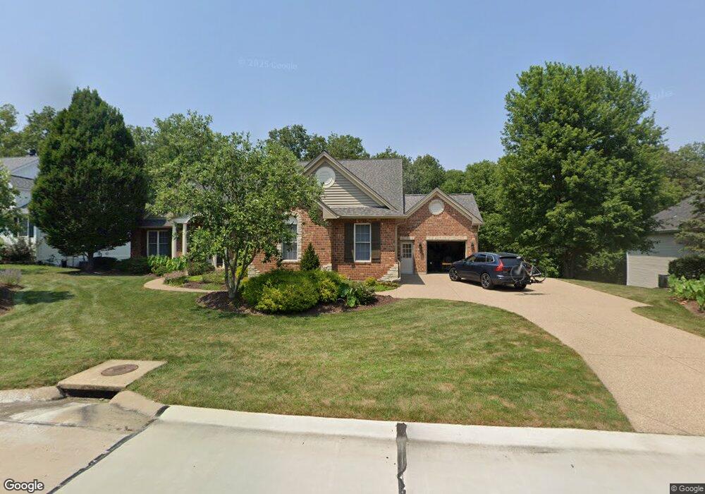
4226 Austin Ridge Dr Saint Charles, MO 63304
Estimated Value: $757,931 - $873,000
3
Beds
2
Baths
2,512
Sq Ft
$328/Sq Ft
Est. Value
About This Home
This home is located at 4226 Austin Ridge Dr, Saint Charles, MO 63304 and is currently estimated at $824,233, approximately $328 per square foot. 4226 Austin Ridge Dr is a home located in St. Charles County with nearby schools including Independence Elementary School, Bryan Middle School, and Francis Howell Union High School.
Ownership History
Date
Name
Owned For
Owner Type
Purchase Details
Closed on
Feb 19, 2003
Sold by
Arbor Homes Inc
Bought by
Kassing James M and Kassing Janet S
Current Estimated Value
Home Financials for this Owner
Home Financials are based on the most recent Mortgage that was taken out on this home.
Original Mortgage
$295,000
Outstanding Balance
$125,025
Interest Rate
5.93%
Estimated Equity
$699,209
Create a Home Valuation Report for This Property
The Home Valuation Report is an in-depth analysis detailing your home's value as well as a comparison with similar homes in the area
Home Values in the Area
Average Home Value in this Area
Purchase History
| Date | Buyer | Sale Price | Title Company |
|---|---|---|---|
| Kassing James M | $369,853 | -- |
Source: Public Records
Mortgage History
| Date | Status | Borrower | Loan Amount |
|---|---|---|---|
| Open | Kassing James M | $295,000 |
Source: Public Records
Tax History Compared to Growth
Tax History
| Year | Tax Paid | Tax Assessment Tax Assessment Total Assessment is a certain percentage of the fair market value that is determined by local assessors to be the total taxable value of land and additions on the property. | Land | Improvement |
|---|---|---|---|---|
| 2025 | $7,409 | $126,354 | -- | -- |
| 2024 | $7,409 | $124,499 | -- | -- |
| 2023 | $7,406 | $124,499 | $0 | $0 |
| 2022 | $6,935 | $108,308 | $0 | $0 |
| 2021 | $6,942 | $108,308 | $0 | $0 |
| 2020 | $6,606 | $99,754 | $0 | $0 |
| 2019 | $6,576 | $99,754 | $0 | $0 |
| 2018 | $6,395 | $92,754 | $0 | $0 |
| 2017 | $6,343 | $92,754 | $0 | $0 |
| 2016 | $6,306 | $88,823 | $0 | $0 |
| 2015 | $6,265 | $88,823 | $0 | $0 |
| 2014 | -- | $85,394 | $0 | $0 |
Source: Public Records
Map
Nearby Homes
- 4 Upper Whitmoor Dr
- 42 Windcastle Place
- 64 Castle Bluff Dr
- 1094 Whitmoor Dr
- 42 Windam Place Dr
- 191 Muirfield Forest Ct
- 263 Ashdown Forest Ct
- 149 Shaelah Ct
- 801 Haversham Dr
- 142 Newgrange Pass
- 3912 Jacobs Landing
- 950 Haversham Dr
- 74 W Meath Ring
- 180 Wholesome Way
- 74 Mondavi Ct
- 5070 Douglas Park Dr
- 350 Healthy Way
- 354 Healthy Way
- 32 Clarksburg Ct
- Westbrook Plan at Kreder Farms
- 4230 Austin Ridge Dr
- 4222 Austin Ridge Dr
- 4234 Austin Ridge Dr
- 4218 Austin Ridge Dr
- 4227 Austin Ridge Dr
- 4223 Austin Ridge Dr
- 4231 Austin Ridge Dr
- 4238 Austin Ridge Dr
- 4219 Austin Ridge Dr
- 4214 Austin Ridge Dr
- 4235 Austin Ridge Dr
- 4215 Austin Ridge Dr
- 4120 Austin Bluff Ct
- 4210 Austin Ridge Dr
- 4243 Austin Ridge Dr
- 4124 Austin Bluff Ct
- 4211 Austin Ridge Dr
- 4246 Austin Ridge Dr
- 5 Pitman Hill Rd
- 5 Pitman Hill Rd